The OFFICIAL Trans NJ Trail Thread

  • HTML tutorial

DVC

Rank V
Launch Member

Enthusiast I

2,093
Hackettstown, NJ
First Name
Aaron
Last Name
R
Member #

16620

Wharton is great some spots can be tight for full size truck
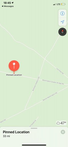
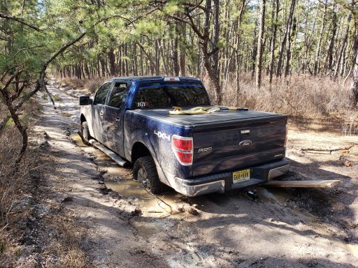
I went down on a ride with Leon and some others a few weeks ago - it was a lot of fun, but we did do one section that was very tight for a full size... I'd prefer to skip any sections that tight in the future.
 

DVC

Rank V
Launch Member

Enthusiast I

2,093
Hackettstown, NJ
First Name
Aaron
Last Name
R
Member #

16620

I recorded my track the whole damn day, except i accidentally let the track shut off for one trail, which so happened to include the tight section (as well as a challenging iced over water/mud hole). Leon knows that whole area like the back of his hand, so I'm sure if i sent him my track with the gap in it, he could fill in the missing trail.
 

Cpol

Rank IX
Launch Member

World Traveler III

15,013
Jackson Heights, Queens, NY, USA
First Name
Chris
Last Name
Pol
Member #

14325

I would be interested in any and all of this trip and corresponding information.
my F150 is stock and is my daily driver so i am more interested in the view and experience at this point. will obviously get more adventurous as both my driving and equipment improve.

I am currently unable to access the maps for the TNJT is it me or my apple?
you will be fine if you avoid the deep puddles and follow the lines of the truck in front of you..
 
  • Like
Reactions: Hank Outdoors

Xplorr313

Rank V
Founder 500
Launch Member

Enthusiast III

2,421
Burlington, NJ
First Name
Leon
Last Name
Jones
Member #

0313

Ham/GMRS Callsign
WQYY816

Xplorr313

Rank V
Founder 500
Launch Member

Enthusiast III

2,421
Burlington, NJ
First Name
Leon
Last Name
Jones
Member #

0313

Ham/GMRS Callsign
WQYY816
Guys, just an update:

I have rerouted some parts of the TNJT due to a detour, to stream line the route a little better up around the Sunrise Mountain area, and to fix an issue with one of the routes in the Pine Barrens.

I will put the updated route in the first post in this thread as soon as I get the route updated. I will also post that it is ready too.

As for trails that are closed, yes Sunrise Mountain is closed and Buttermilk Falls is closed due to weather. High Point State Park is normally closed too but as of this past Sunday, 3-24-19, it is open.

Also, guys any questions you have, please direct them to me. I will do whatever I can to answer them and to help you with the route. I know this route better than anyone else. For whatever reason I don’t get notified about post to this thread so you may need to send me a PM if you have any questions. You can always reach out to me by email: xplorr313@gmail.com too.
 

RockU

Rank IV

Enthusiast III

Looks like normal Pine Barrens to me. Do you know what section this was? Doesn’t look like anything that’s part of the TNJT unless recent rains really did a number on it.
This is where the pictures got taken, my wife saved the location because I got stuck lol there were about 2ft deep water crossings and fallen trees on the same road, so had to turn around.
 

Attachments

Xplorr313

Rank V
Founder 500
Launch Member

Enthusiast III

2,421
Burlington, NJ
First Name
Leon
Last Name
Jones
Member #

0313

Ham/GMRS Callsign
WQYY816
This is where the pictures got taken, my wife saved the location because I got stuck lol there were about 2ft deep water crossings and fallen trees on the same road, so had to turn around.
That’s actually kinda crazy cause that section is never that bad besides a small section where there was a couple holes here and there but they usually had go arounds.

In the photo I attached, the blue circled spots are the two spots that usually have deep holes but have go arounds. The red “pin” is about where your pin was. Were you coming from the blue circles headed toward your pin or at your pin headed toward the blue circles?
 

Attachments

RockU

Rank IV

Enthusiast III

That’s actually kinda crazy cause that section is never that bad besides a small section where there was a couple holes here and there but they usually had go arounds.

In the photo I attached, the blue circled spots are the two spots that usually have deep holes but have go arounds. The red “pin” is about where your pin was. Were you coming from the blue circles headed toward your pin or at your pin headed toward the blue circles?
At my pin heading towards the blue circle I think. The small blue circle is prob where 2 big trees where blocking the road and I had to turn back
 
  • Like
Reactions: Xplorr313

Xplorr313

Rank V
Founder 500
Launch Member

Enthusiast III

2,421
Burlington, NJ
First Name
Leon
Last Name
Jones
Member #

0313

Ham/GMRS Callsign
WQYY816
At my pin heading towards the blue circle I think. The small blue circle is prob where 2 big trees where blocking the road and I had to turn back
Ahh gotcha. Hrmmm I guess I’ll need to reroute that section as well. When did you traverse that trail?
 

Xplorr313

Rank V
Founder 500
Launch Member

Enthusiast III

2,421
Burlington, NJ
First Name
Leon
Last Name
Jones
Member #

0313

Ham/GMRS Callsign
WQYY816
Last sunday. The last section of Wharton, before the zillon bypass, also had very long and deep water crossings. To deep for me to dare to cross them.
Due to all the rain we have gotten lately, that doesn’t surprise me. Unfortunately I can’t keep by passing everything or the trail will just turn into riding the highways haha.
 
  • Like
Reactions: potcake

Xplorr313

Rank V
Founder 500
Launch Member

Enthusiast III

2,421
Burlington, NJ
First Name
Leon
Last Name
Jones
Member #

0313

Ham/GMRS Callsign
WQYY816
Yeah, we don't want that lol

I'm sure the tree's will be taken care of as soon as it dries up some
I did reroute the section where you got stuck and where the trees were down. All is good and no asphalt needed to be traversed for the by pass.