OB Approved Personal Satellite Communicators

  • HTML tutorial

ovrlndr

Rank VI
Launch Member

Influencer II

4,353
Denver, CO, USA
First Name
Jason
Last Name
Broom
Member #

1375

Everyone participating in outdoor recreation of any kind in remote areas, especially those where cell reception is spotty or non-existent, contact with other people is infrequent, and the elements and/or terrain can lead to accidents, injury, or death should consider some type of personal satellite communicator.

A few incidents led me to finally bite the bullet and purchase one:
  • I've experienced four "non-starts" on a brand new Mercedes Sprinter van that I had owned for less than 3 weeks and had less than 1,000 miles on the odometer. Two of the non-starts came on mountain passes in areas with no cell reception. I have roadside assistance in my vehicle insurance and it's included in the warranty on the van... but it is of absolutely no use if I cannot contact them.
  • On day 2 of what was to be a 5 day overlanding trip, one of the motor mount brackets on the engine oil pan skid plate I run on my Jeep wore a hole through the engine oil pan. Yes, I understand the irony of the situation. No, it was not funny. Yes, my friends that were on the trip bust my chops about it. Luckily, I was with 7 other experienced people and one of them had a roll of QuikSteel handy. If this had happened earlier on the trip, we would have been without cell service. If this had happened later on the trip, we would have been without cell service. If this had happened to me when I was out by myself, I may have been without cell service and likely would not have been equipped to make the repair (though, you can probably guess what I now carry a roll of in my on-board toolkit)
  • I have had several pretty rough falls on my mountain bike and snowboard. It's a risk that comes with the sports. Even the best athletes in the world still have crashes and accidents. Many times when I'm on the bike or on the board, I have no cell reception.
Beyond vehicular issues, or accidents that could lead to injury or death during outdoor activities, there are other reasons to carry a personal satellite communicator. Keeping in touch with friends, family, or (however unfortunate) work may be reason enough for some. Pre-existing medical conditions may be a concern to some; for example, one of my buddies has a son with hemophilia (disorder in which blood does not clot normally). It's possible that simply tripping over a rock at a campsite could result in a serious medical situation, and depending on where he is, one that could require immediate evacuation. Heart conditions or other medical conditions are great reasons that you may want to consider carrying a satellite communicator with you.

Personal satellite communicators come in various sizes, with various features, plans, and related costs, so there is probably one that will suit your particular needs, wants, and budget.

What I would look for in a device is the ability to at least have a tracking feature, so that someone that is not out with you can track your location and communicate it to emergency services if needed, the ability to send at least some sort of message to someone that is not with you (whether it be a full blown text message or email, or just a canned message), and an SOS feature (which communicates directly to emergency services / SAR teams and can include things like getting a helicopter evacuation to your location if necessary).

Personally, I own the Garmin inReach Explorer+, but there are a lot of these devices available on the market, and there are plenty of sites that review them and go into much more detail, but I will list the more common ones for outdoor adventurers below.

  • Garmin inReach Mini
    • Garmin's newest entry into the inReach series, the Mini (as its name indicates) is a lightweight and compact satellite communicator
    • Least expensive of the inReach devices
    • While the device does have a display, it is a monochrome MIP screen which is smaller than the other devices in the inReach series
    • It does not have internal memory or preloaded maps
    • In order to use certain features (like mapping), you must pair the Mini to another device (like an iPhone), which could be an issue if you are without your phone, your phone breaks, or the battery on your phone dies
    • 500 waypoints, 20 routes
    • Battery life is not as good as the larger inReach devices (but pretty close in the default mode), but this is a cost of a smaller form factor
    • Bluetooth compatible
    • Triggers an interactive SOS to 24/7 search and rescue monitoring center (GEOS response)
    • Send and receive text messages to SMS and email (includes link to location on map)
    • Send and receive messages with other inReach users and exchange locations
    • Track and share location with friends and family on web-based mapping portal
    • Request weather forecasts for current location and planned destination
    • Virtual keyboard for custom text messaging
    • Send waypoints to mapping portal during trip
    • Send route selection to mapping portal for friends and family to see progress
  • Garmin inReach SE+
    • Similar to the inReach Explorer+, the SE+ lacks the built-in memory, the preloaded DeLorme topo maps, the barometric altimeter, the digital compass, and the accelerometer that are in the Explorer+, but other than these, has the same features as the Explorer+ // I believe the lack of digital compass means that you have to be moving for this to determine your heading, whereas you can determine direction when standing still using the Explorer+
    • It is the same size and weight as the Explorer+ and has the same battery life and number of waypoints and routes, as well
    • I personally think the maps, built-in memory, and sensors are worth the $50 upcharge to the Explorer+
  • Garmin inReach Explorer+
    • This is the granddaddy of Garmin's inReach series, and includes 2GB built-in memory, preloaded DeLorme topo maps, barometric altimeter (more accurate than altitude reading provided by GPS), digital compass, and accelerometer
    • 500 waypoints, 20 routes
    • Bluetooth compatible
    • Triggers an interactive SOS to 24/7 search and rescue monitoring center (GEOS response)
    • Sends and receives text messages to SMS and email (includes link to location on map)
    • Send and recieves messages with other inReach users and exchange locations
    • Track and share location with friends / family on web-based mapping portal
    • Request weather forecasts for current location and planned destination
    • Virtual keyboard for custom text messaging
    • Send waypoints to mapping portal during trip
    • Send route selection to mapping portal for friends and family to see progress
  • SPOT Gen3
    • Less expensive than the least expensive inReach device (Mini) by a couple hundred dollars
    • No display screen
    • Compact form factor
    • Custom tracking rates and continuous, motion-activated tracking
    • SOS button - With the push of a button, GEOS International Emergency Response Coordination Center provides your GPS coordinates and information to local response teams - for example contacting 9-1-1 responders in North America and 1-1-2 responders in Europe
    • Check-in button - Let family and friends know you're ok when you're out of cell phone range. Send a pre-programmed text message with GPS coordinates or an email with a link to Google Maps™ to your contacts with your location. With a push of a button, a message is sent via email or SMS to up to 10 pre-determined contacts and your waypoint is stored in your SPOT account for later reference. Your stored waypoints can be easily integrated into a SPOT Shared Page or SPOT Adventure account.
    • Help / Save Our Vehicle (S.O.V.) button - Alert your personal contacts that you need help in non-life-threatening situations. Or, use SPOT S.O.V. for professional services on land. (Additional service required).
    • Custom message button - Stay in touch while off the grid by sending your custom message. Set up a message before leaving to send to contacts with your GPS location. Use this feature as a secondary OK message or transfer your personal help alert to this message function if you are using a SPOT S.O.V. service on your Help button.
    • Better battery life than the inReach series, but fewer features
As mentioned above, there are quite a few places to find detailed reviews of these devices, as well as other devices not mentioned above. These are the devices that I had considered as my final contenders when doing my own research, but I would encourage you all to spend some time reading reviews to see what device may best suit your needs and budget. SPOT also recently, in the last few months, released the SPOT X which compares better with the larger inReach (SE+ / Explorer+) units and offers all of the features of the SPOT, plus messaging / email via a full (BlackBerry-esque) keyboard and a compass.

I gave an overview of several different units available on the market mostly to show the types of features that you may want to look for; as technology progresses and this article ages, some of these devices may become obsolete as newer devices and features are released, BUT the features in the devices listed above are still a GREAT baseline for choosing a device that will get you out of trouble.

Whatever the device, it is a smart choice to carry a personal satellite communicator with you when venturing into the backcountry as we overlanders are known to do...

Below are some images of the various devices mentioned in this article, and some images of size comparisons of the units.
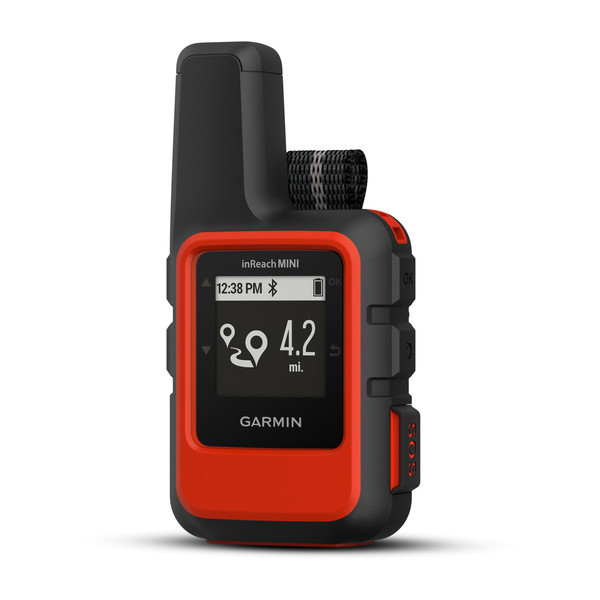

Garmin inReach Mini
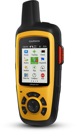

Garmin inReach SE+
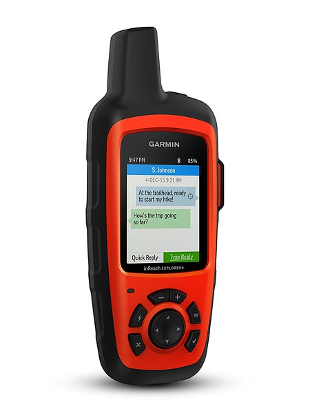

Garmin inReach Explorer+
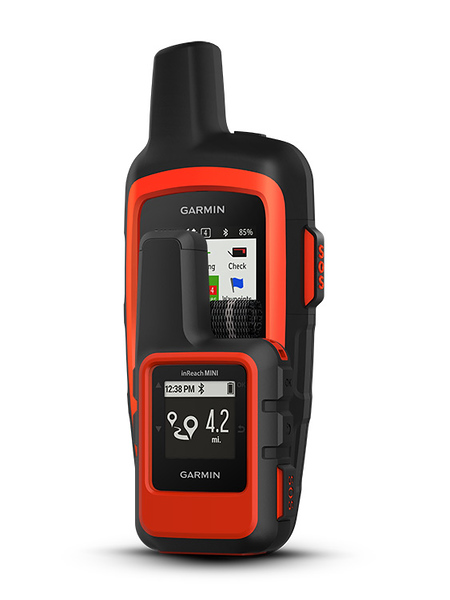

Size Comparison: Garmin inReach Mini and Garmin inReach Explorer+
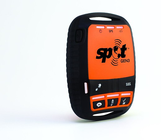

Spot Gen3
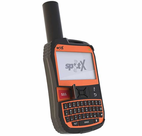

SpotX
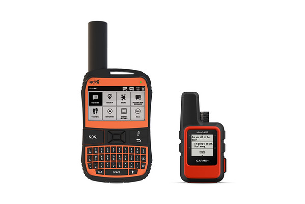

Size Comparison: SpotX and Garmin inReach Mini
 
Last edited:

SVgarage

Rank V
Launch Member

Off-Road Ranger I

2,298
Livermore, California
First Name
Eddy
Last Name
Louis
Member #

13770

Ham/GMRS Callsign
KO6BOH
Very helpful. Recently, I have been investigating some of the different options as you have listed. I've got elderly parents and while in the back-country, I feel it would be necessary for me to have 2-way communication, so that family could reach me in case a crisis should occur. I'm still weighing the options. But I do know that Spot runs some pretty aggressive promotions. West Marine had a deal on the Spot Gen3 just last week for 50% off. I am patiently waiting to see if the Spot X might have any discounts during the Holiday season. Meanwhile, I'm still combing through reviews on both brands.
 

Corbet

Rank V
Launch Member

Pathfinder I

2,055
Durango, CO
First Name
Corbet
Last Name
Hoover
Member #

1204

I have an older InReach and love it. I pair it with my iPhone or iPad as typing without a keyboard sucks. Also paired you have access to your address book so your not manually entering numbers/email to send a message. I use Garmin’s Earthmate app for saved tops maps etc... battery life is a couple days, better than any phone. Charges fast off a USB in the truck. Wife loves it as I’m after traveling solo with our young son. Gives her piece of mind.

I made my choice mainly from an article in Overland Journal at the time. Another important thing to note is the type of system the communicator accesses to reach the outside world. The various differences I have long since forgotten. But if your in the current market realize there are differences there too and choose one what best suits your needs.
 
Last edited:

Cort

Rank VI
Launch Member

Trail Blazer III

5,197
Grand Rapids
First Name
Cort
Last Name
Beard
Member #

5247

Ham/GMRS Callsign
KD8GQL
I used the InReach mini along with my iPad Pro on my 5700 mile expedition to Labrador Canada this fall and it worked flawlessly. Tracking was awesome and the texting was incredibly helpful. Sold me for sure.
 

AprilC

Rank V
Launch Member

Enthusiast III

2,239
Rocklin, CA
Member #

10754

In addition, with the Garmin inReach Explorer+, you can talk to other devices by using the email for your device, not your personal email, but your Garmin email. So when you are meeting up with another rig and have no cell reception, you can still communicate. I thought this was pretty cool, on top of being able to communicate via sending text and email to another person, you can communicate device to device.
 

Willys_2014

Rank IV
Launch Member

Advocate III

1,346
AZ, USA
First Name
G
Last Name
B
Member #

18391

I am a fan of the Garmin inReach, and actually had the unfortunate occasion of calling an emergency/SOS when a Grand Canyon multiday backpacking trip went wrong.

I wrote about this experience on another forum, with the initials EP, and if it's okay with the mods I will add a link.

But, most relevant to the thread, I was very impressed with the responsiveness and professionalism of Garmin's team.

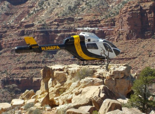
Garmin stayed with us until the arrival of this beautiful bird:

DSCN0947~2.JPG

There is a whole story in and of itself about the young woman who landed that MD500 precariously, not once, but twice.

The NPS Rangers and SAR team were absolutely wonderful too. The elapse time from accident to Flagstaff ER was ~5 hours. And, I fully expected to spend an uncomfortable night in an uncomfortable place.

Anyhow, I find the Garmin to be a great tool to maintain routine contact out in the backcountry. The native mode keyboard sucks, the SE version, but I can live with it. Note: if I am backpacking I don't mess around with Bluetooth pairing.
 

jimbofoxman

Rank V
Launch Member

Member III

1,988
Oshtemo Township, MI, USA
Member #

16236

Glad everything worked out!

I myself got evacuated out of the Superstitions myself in April. Fortunately we had cell signal as we didn't have a Garmin. I got 2 different Helicopters (first couldn't get to me and I couldn't walk up to where it landed), 2 people hiking down from first helo, IV and then the 2nd helo hovering one skid on a rock and taking us out. Daughter got to ride down too. I think ours was about 5 or 6 hrs as we had to wait another hour for the 2nd helo to come from Tucson.
 

4wheelspulling

Rank VI
Launch Member

Member III

3,065
Chelan, WA.
First Name
Vance
Last Name
Myers
Member #

8452

Can I ask how much it ended costing for the emergency response and rescue? I know you can’t put a price on saving your life or others out in the wilds when an accident happens! Vance.
 

ovrlndr

Rank VI
Launch Member

Influencer II

4,353
Denver, CO, USA
First Name
Jason
Last Name
Broom
Member #

1375

Can I ask how much it ended costing for the emergency response and rescue? I know you can’t put a price on saving your life or others out in the wilds when an accident happens! Vance.
I started another thread on the importance of SAR cards and insurance, but the short answer is “it depends.” It depends on where you are, and it also depends on your circumstances, etc.

I don’t have the link to the other thread handy at the moment, but I’ll try to dig it up and cross post it here.
 

ovrlndr

Rank VI
Launch Member

Influencer II

4,353
Denver, CO, USA
First Name
Jason
Last Name
Broom
Member #

1375

I started another thread on the importance of SAR cards and insurance, but the short answer is “it depends.” It depends on where you are, and it also depends on your circumstances, etc.

I don’t have the link to the other thread handy at the moment, but I’ll try to dig it up and cross post it here.
The Importance of Search and Rescue Insurance, Donations, and SAR Cards (US)
 

4wheelspulling

Rank VI
Launch Member

Member III

3,065
Chelan, WA.
First Name
Vance
Last Name
Myers
Member #

8452

The Importance of Search and Rescue Insurance, Donations, and SAR Cards (US)
ovrlndr,
Thank you, for your response and the great information in the article link! Good on you! Something worth looking more into for my peace of mind. Vance.
 
  • Like
Reactions: Drifterman

jimbofoxman

Rank V
Launch Member

Member III

1,988
Oshtemo Township, MI, USA
Member #

16236

Can I ask how much it ended costing for the emergency response and rescue? I know you can’t put a price on saving your life or others out in the wilds when an accident happens! Vance.
Not sure if it's different up in the GC, but for me their was no cost passed on to me. I was in the Superstitions by Gold Canyon just outside of Apache Junction. Straight from the officer's mouth that the State of Arizona covers it in their annual budget. That was almost 2 months ago and I haven't heard anything beyond that day of the incident. It was my understanding that it was a statewide thing. Not sure what would of happened if their was an ER visit. By the time the second helo got there and got us down my vitals were only slightly elevated and I opted out of going.
 

Willys_2014

Rank IV
Launch Member

Advocate III

1,346
AZ, USA
First Name
G
Last Name
B
Member #

18391

Can I ask how much it ended costing for the emergency response and rescue? I know you can’t put a price on saving your life or others out in the wilds when an accident happens! Vance.
Nothing for me.

It is my understanding that in the Grand Canyon, the NPS will not charge a fee for a helicopter rescue if you a) have a valid backcountry permit, and b) experience a legitimate emergency (as determined by the SAR team).

I have heard anecdotal stories about fees as high as $5K for a non emergency extraction.

Having said that, I have not seen any official document, policies, etc.; this is just my experience.
 

Willys_2014

Rank IV
Launch Member

Advocate III

1,346
AZ, USA
First Name
G
Last Name
B
Member #

18391

Glad everything worked out!

I myself got evacuated out of the Superstitions myself in April. Fortunately we had cell signal as we didn't have a Garmin. I got 2 different Helicopters (first couldn't get to me and I couldn't walk up to where it landed), 2 people hiking down from first helo, IV and then the 2nd helo hovering one skid on a rock and taking us out. Daughter got to ride down too. I think ours was about 5 or 6 hrs as we had to wait another hour for the 2nd helo to come from Tucson.
Glad as well to hear everything went okay for you too!

I seem to recall hearing about this on the local news. I am in Florence, btw.

What trail in the Superstitions if you don't mind me asking?
 
Last edited:

ovrlndr

Rank VI
Launch Member

Influencer II

4,353
Denver, CO, USA
First Name
Jason
Last Name
Broom
Member #

1375

Nothing for me.

It is my understanding that in the Grand Canyon, the NPS will not charge a fee for a helicopter rescue if you a) have a valid backcountry permit, and b) experience a legitimate emergency (as determined by the SAR team).

I have heard anecdotal stories about fees as high as $5K for a non emergency extraction.

Having said that, I have not seen any official document, policies, etc.; this is just my experience.
I’ve also read / heard about costs being passed on when someone needed to be rescued from a situation that was caused by recklessness.
 

Willys_2014

Rank IV
Launch Member

Advocate III

1,346
AZ, USA
First Name
G
Last Name
B
Member #

18391

I’ve also read / heard about costs being passed on when someone needed to be rescued from a situation that was caused by recklessness.
Oh yeah. Bad place to be reckless.

Over the Edge: Death in Grand Canyon
I have been backpacking pretty regularly in the Grand Canyon backcountry since 1995, and fools are not suffered gladly.

Neither does the Park Service, rightly so.
 
  • Like
Reactions: Drifterman

ovrlndr

Rank VI
Launch Member

Influencer II

4,353
Denver, CO, USA
First Name
Jason
Last Name
Broom
Member #

1375

Oh yeah. Bad place to be reckless.

Over the Edge: Death in Grand Canyon
I have been backpacking pretty regularly in the Grand Canyon backcountry since 1995, and fools are not suffered gladly.

Neither does the Park Service, rightly so.
I’m not only referring to the Grand Canyon; I’ve heard / read about costs of SAR operations being passed on to those that were in the situation due to recklessness in a multitude of different locations.
 

4wheelspulling

Rank VI
Launch Member

Member III

3,065
Chelan, WA.
First Name
Vance
Last Name
Myers
Member #

8452

As more and more people get out and start enjoying the outdoors around the world, this service Information needs more attention! Even, if you don’t have a known medical issue, those In the know should spread the word. As an X mountain climber, I thought it a good practice to have a safety beacon Incase something happened. Now as an older Male, I think this equipment should be part of my personal Overland equipment. Vance.
 

jimbofoxman

Rank V
Launch Member

Member III

1,988
Oshtemo Township, MI, USA
Member #

16236

Glad as well to hear everything went okay for you too!

I seem to recall hearing about this on the local news. I am in Florence, btw.

What trail in the Superstitions if you don't mind me asking?
Mine was on April 3. I'm from Michigan. Dad lives in Apache Junction right where it turns from highway into divided. My sister lives in Mesa out by the old GM Test Track.

We went up Peralta to Lone Tree and then decided to come down Cave Trail which was the down fall. Wasn't bad until you are basically sliding down rock faces. I didn't realize it was Cave Trail when we decided to go back down that way. I read so many trail descriptions and just dropped the ball on that one. So we started back up and I was stopping every 10 feet or so of climb and catching my breath for several minutes. Last place we stopped I didn't move for 2 hour and it took me probably 20 mins to stop breathing heavy. Thought I was going to pass out, couldn't eat anything. Some of it was anxiety of having to go back up. Lot was dehydration and too much hiking over the past few days. I don't remember my blood pressure when the first person in go to me but she said.......nope you are not hiking back up. Then they made the call to get the second helicopter outta Tucson.

My daughter's video of me climbing in. Video 1

My daughter's flight down. First helicopter (old Huey) was up at the top just down from Lone Tree area. I don't remember any of the flight other than getting in and landing. Video 2

Sorry to hijack the tread........I only wanted to add my experience when someone asked about cost.