Everyone participating in outdoor recreation of any kind in remote areas, especially those where cell reception is spotty or non-existent, contact with other people is infrequent, and the elements and/or terrain can lead to accidents, injury, or death should consider some type of personal satellite communicator.
A few incidents led me to finally bite the bullet and purchase one:
- I've experienced four "non-starts" on a brand new Mercedes Sprinter van that I had owned for less than 3 weeks and had less than 1,000 miles on the odometer. Two of the non-starts came on mountain passes in areas with no cell reception. I have roadside assistance in my vehicle insurance and it's included in the warranty on the van... but it is of absolutely no use if I cannot contact them.
- On day 2 of what was to be a 5 day overlanding trip, one of the motor mount brackets on the engine oil pan skid plate I run on my Jeep wore a hole through the engine oil pan. Yes, I understand the irony of the situation. No, it was not funny. Yes, my friends that were on the trip bust my chops about it. Luckily, I was with 7 other experienced people and one of them had a roll of QuikSteel handy. If this had happened earlier on the trip, we would have been without cell service. If this had happened later on the trip, we would have been without cell service. If this had happened to me when I was out by myself, I may have been without cell service and likely would not have been equipped to make the repair (though, you can probably guess what I now carry a roll of in my on-board toolkit)
- I have had several pretty rough falls on my mountain bike and snowboard. It's a risk that comes with the sports. Even the best athletes in the world still have crashes and accidents. Many times when I'm on the bike or on the board, I have no cell reception.
Beyond vehicular issues, or accidents that could lead to injury or death during outdoor activities, there are other reasons to carry a personal satellite communicator. Keeping in touch with friends, family, or (however unfortunate) work may be reason enough for some. Pre-existing medical conditions may be a concern to some; for example, one of my buddies has a son with hemophilia (disorder in which blood does not clot normally). It's possible that simply tripping over a rock at a campsite could result in a serious medical situation, and depending on where he is, one that could require immediate evacuation. Heart conditions or other medical conditions are great reasons that you may want to consider carrying a satellite communicator with you.
Personal satellite communicators come in various sizes, with various features, plans, and related costs, so there is probably one that will suit your particular needs, wants, and budget.
What I would look for in a device is the ability to at least have a tracking feature, so that someone that is not out with you can track your location and communicate it to emergency services if needed, the ability to send at least some sort of message to someone that is not with you (whether it be a full blown text message or email, or just a canned message), and an SOS feature (which communicates directly to emergency services / SAR teams and can include things like getting a helicopter evacuation to your location if necessary).
Personally, I own the Garmin inReach Explorer+, but there are a lot of these devices available on the market, and there are plenty of sites that review them and go into much more detail, but I will list the more common ones for outdoor adventurers below.
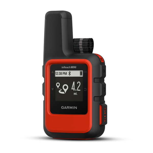
- Garmin inReach Mini
- Garmin's newest entry into the inReach series, the Mini (as its name indicates) is a lightweight and compact satellite communicator
- Least expensive of the inReach devices
- While the device does have a display, it is a monochrome MIP screen which is smaller than the other devices in the inReach series
- It does not have internal memory or preloaded maps
- In order to use certain features (like mapping), you must pair the Mini to another device (like an iPhone), which could be an issue if you are without your phone, your phone breaks, or the battery on your phone dies
- 500 waypoints, 20 routes
- Battery life is not as good as the larger inReach devices (but pretty close in the default mode), but this is a cost of a smaller form factor
- Bluetooth compatible
- Triggers an interactive SOS to 24/7 search and rescue monitoring center (GEOS response)
- Send and receive text messages to SMS and email (includes link to location on map)
- Send and receive messages with other inReach users and exchange locations
- Track and share location with friends and family on web-based mapping portal
- Request weather forecasts for current location and planned destination
- Virtual keyboard for custom text messaging
- Send waypoints to mapping portal during trip
- Send route selection to mapping portal for friends and family to see progress
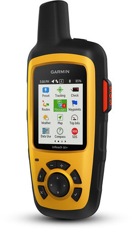
- Garmin inReach SE+
- Similar to the inReach Explorer+, the SE+ lacks the built-in memory, the preloaded DeLorme topo maps, the barometric altimeter, the digital compass, and the accelerometer that are in the Explorer+, but other than these, has the same features as the Explorer+ // I believe the lack of digital compass means that you have to be moving for this to determine your heading, whereas you can determine direction when standing still using the Explorer+
- It is the same size and weight as the Explorer+ and has the same battery life and number of waypoints and routes, as well
- I personally think the maps, built-in memory, and sensors are worth the $50 upcharge to the Explorer+
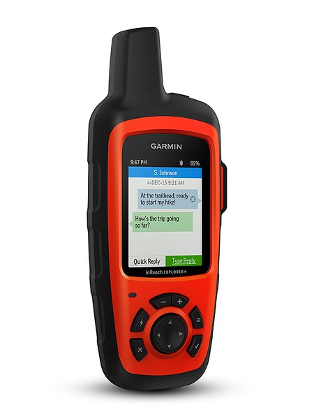
- Garmin inReach Explorer+
- This is the granddaddy of Garmin's inReach series, and includes 2GB built-in memory, preloaded DeLorme topo maps, barometric altimeter (more accurate than altitude reading provided by GPS), digital compass, and accelerometer
- 500 waypoints, 20 routes
- Bluetooth compatible
- Triggers an interactive SOS to 24/7 search and rescue monitoring center (GEOS response)
- Sends and receives text messages to SMS and email (includes link to location on map)
- Send and recieves messages with other inReach users and exchange locations
- Track and share location with friends / family on web-based mapping portal
- Request weather forecasts for current location and planned destination
- Virtual keyboard for custom text messaging
- Send waypoints to mapping portal during trip
- Send route selection to mapping portal for friends and family to see progress
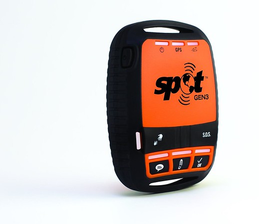
- SPOT Gen3
- Less expensive than the least expensive inReach device (Mini) by a couple hundred dollars
- No display screen
- Compact form factor
- Custom tracking rates and continuous, motion-activated tracking
- SOS button - With the push of a button, GEOS International Emergency Response Coordination Center provides your GPS coordinates and information to local response teams - for example contacting 9-1-1 responders in North America and 1-1-2 responders in Europe
- Check-in button - Let family and friends know you're ok when you're out of cell phone range. Send a pre-programmed text message with GPS coordinates or an email with a link to Google Maps™ to your contacts with your location. With a push of a button, a message is sent via email or SMS to up to 10 pre-determined contacts and your waypoint is stored in your SPOT account for later reference. Your stored waypoints can be easily integrated into a SPOT Shared Page or SPOT Adventure account.
- Help / Save Our Vehicle (S.O.V.) button - Alert your personal contacts that you need help in non-life-threatening situations. Or, use SPOT S.O.V. for professional services on land. (Additional service required).
- Custom message button - Stay in touch while off the grid by sending your custom message. Set up a message before leaving to send to contacts with your GPS location. Use this feature as a secondary OK message or transfer your personal help alert to this message function if you are using a SPOT S.O.V. service on your Help button.
- Better battery life than the inReach series, but fewer features
As mentioned above, there are quite a few places to find detailed reviews of these devices, as well as other devices not mentioned above. These are the devices that I had considered as my final contenders when doing my own research, but I would encourage you all to spend some time reading reviews to see what device may best suit your needs and budget. SPOT also recently, in the last few months, released the
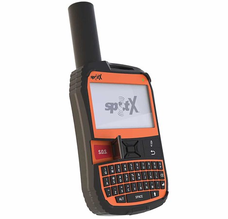
SPOT X which compares better with the larger inReach (SE+ / Explorer+) units and offers all of the features of the SPOT, plus messaging / email via a full (BlackBerry-esque) keyboard and a compass.
I gave an overview of several different units available on the market mostly to show the types of features that you may want to look for; as technology progresses and this article ages, some of these devices may become obsolete as newer devices and features are released, BUT the features in the devices listed above are still a GREAT baseline for choosing a device that will get you out of trouble.
Whatever the device, it is a smart choice to carry a personal satellite communicator with you when venturing into the backcountry as we overlanders are known to do...
Below are some images of the various devices mentioned in this article, and some images of size comparisons of the units.
Garmin inReach Mini
Garmin inReach SE+
Garmin inReach Explorer+
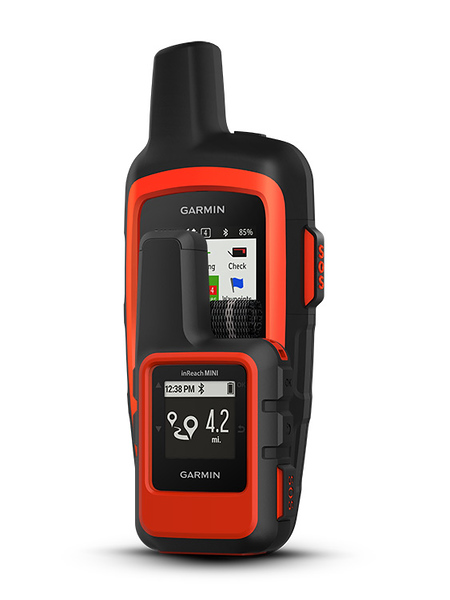
Size Comparison: Garmin inReach Mini and Garmin inReach Explorer+
Spot Gen3
SpotX
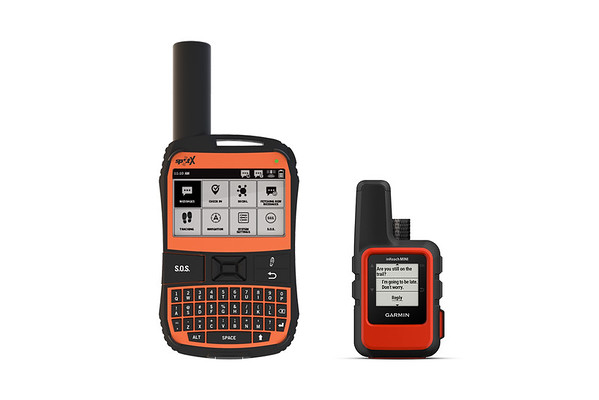
Size Comparison: SpotX and Garmin inReach Mini