US Southeast Land Between the Lakes trip

  • HTML tutorial

SJ.Overland

Rank VII
Member

Trail Blazer I

6,140
Beavercreek, OH, USA
First Name
Shaun
Last Name
Johannes
Member #

15310

Ham/GMRS Callsign
KE8TDZ
I don’t think there’s anything other than general camping and wheeling common sense. Don’t drive through someone’s site, that kind of thing, lol. When we’re exploring we walk the trails if it starts looking iffy. Unless you’re @4runnerteq then you just launch yourself over a hill and hope for the best. Don’t forget to buy your camping permit. $7. I take a screen shot to have on my phone just in case. Oh! There’s mostly no signal, so download whatever music you want before you go!
Awesome thanks! I had a feeling signal would be nonexistent. I'm already working on the permits so good there!
 

SJ.Overland

Rank VII
Member

Trail Blazer I

6,140
Beavercreek, OH, USA
First Name
Shaun
Last Name
Johannes
Member #

15310

Ham/GMRS Callsign
KE8TDZ
So my trip last summer was great. Bringing a new crew again with me here in a few weeks. It's going to be their first time. I feel like I have a better grasp this time after my last trip. We posted up in Ginger Bay and in a small bay in between sugar and duncan bays. We are going to start from the south this time and work our way north. Anyone have any input on roads not worth adventuring down if we're looking for more of a challenge overall? I'm also trying to stay off pavement as much as possible so some of the easy gravel and dirt roads are being used for that.
 

Ronin1057

Rank II
Member

Contributor III

327
Knoxville, TN, USA
First Name
Matthew
Last Name
Username Ronin1057
Member #

26385

Hey all , I’m new to the site and to currently building up my rig. (I’m needing skids and a wench) I’m not far from here so this is definitely on my to do list for this year for the first time. I’m curious about any input on the roads not worth traveling on as well and staying off pavement as much as possible especially since I’ve never been there. Hope y’all have a great trip also @Sjo527.
 
  • Like
Reactions: SJ.Overland

NashvilleKara

Rank IV
Launch Member

Enthusiast III

1,183
Nashville, TN, USA
First Name
Kara
Last Name
Stephens
Member #

18571

@Ronin1057 and @Sjo527 There are a ton of trails that have easy parts that lead into very tricky ones. 300 level will provide the most challenge typically. It also depends on rain and usage. 375 gets a lot of Jeep runs so it tends to be really rutted. Our last trip through there (behind two jeeps) took 3 rigs over an hour to go 50 yards. Just map it out before hand if you want to avoid pavement. I recommend the paid for version of Gaia GPS. It has an overlay with the trail numbers, allows you to save runs and pictures that you take through the app that GPS pins them and you can share runs.
 

SJ.Overland

Rank VII
Member

Trail Blazer I

6,140
Beavercreek, OH, USA
First Name
Shaun
Last Name
Johannes
Member #

15310

Ham/GMRS Callsign
KE8TDZ
@Ronin1057 and @Sjo527 There are a ton of trails that have easy parts that lead into very tricky ones. 300 level will provide the most challenge typically. It also depends on rain and usage. 375 gets a lot of Jeep runs so it tends to be really rutted. Our last trip through there (behind two jeeps) took 3 rigs over an hour to go 50 yards. Just map it out before hand if you want to avoid pavement. I recommend the paid for version of Gaia GPS. It has an overlay with the trail numbers, allows you to save runs and pictures that you take through the app that GPS pins them and you can share runs.
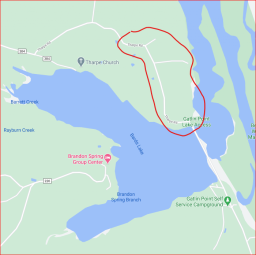
Thanks! I've already mapped that out with Gaia. Was just looking if there was anything that came to mind that wasn't worth the time to go down. I guess I do have one other question though. Is Tharpe RD closed going towards gatling point ramp? In Gaia it shows as not open but google and other sources list it still.

1612546414192.png
 

NashvilleKara

Rank IV
Launch Member

Enthusiast III

1,183
Nashville, TN, USA
First Name
Kara
Last Name
Stephens
Member #

18571

@Ronin1057 and @Sjo527 There are a ton of trails that have easy parts that lead into very tricky ones. 300 level will provide the most challenge typically. It also depends on rain and usage. 375 gets a lot of Jeep runs so it tends to be really rutted. Our last trip through there (behind two jeeps) took 3 rigs over an hour to go 50 yards. Just map it out before hand if you want to avoid pavement. I recommend the paid for version of Gaia GPS. It has an overlay with the trail numbers, allows you to save runs and pictures that you take through the app that GPS pins them and you can share runs.
Thanks! I've already mapped that out with Gaia. Was just looking if there was anything that came to mind that wasn't worth the time to go down. I guess I do have one other question though. Is Tharpe RD closed going towards gatling point ramp? In Gaia it shows as not open but google and other sources list it still.

View attachment 186590
There are several trails that have conflicting information. We went down a few last trip that we’re supposed to be open that ended up being overgrown to the point of being closed. If there is a ramp involved I would guess it’s open.
 
  • Like
Reactions: SJ.Overland