Traveler I
Dude! I live just next to you in Olathe! id be interested in meeting up with you and some others on here.
Let’s try to do a meetup soon. I’m in Roeland Park.
Traveler I
Dude! I live just next to you in Olathe! id be interested in meeting up with you and some others on here.

Traveler III
7082
As far as I know, it's public. I ran a questionable section for @caswanson between Cottonwood Falls and Teter Rock without any issues with the route. Depending on when you want to run it, I might be able to go.Hey guys! I'm just recently taking the plunge into the overland scene and I was looking at caswanson's flint hills route and want to run that over spring break with our two 4runners. just wondering if you guys cleared up weather the whole route listed was public or not.
On another note I'm really exited to meet more fellow Kansans who are into something that interests me as well!
Traveler III
7082
If Emporia counts....Is there anyone out there from the south central area of the State?
I plan on running it sometime during my spring break March 10-16As far as I know, it's public. I ran a questionable section for @caswanson between Cottonwood Falls and Teter Rock without any issues with the route. Depending on when you want to run it, I might be able to go.
Also what do you mean by questionable?As far as I know, it's public. I ran a questionable section for @caswanson between Cottonwood Falls and Teter Rock without any issues with the route. Depending on when you want to run it, I might be able to go.
If Emporia counts....
Traveler III
7082
Yessir, I'm part of the Konza Overland group.So far you're the closest! You're actually in the extrem top left corner of the southeastern zone for Kansas. Basically, you're where the northeastern, southeastern and south central zones meet. Nice spot to be located - right in the middle of the main area of the State.
I'm trying to find people in the lower half of the south central area as well as the lower southwestern corner of the southeastern zone. I'd like to get some sort of local club started, so far nothing. You know, something along the lines of a group that gets out and does things, yet can easily get together for coffee or a beer. There are a couple OB members in my area but I haven't been able to establish contact with them.
However....you are definitely close enough for meeting up somewhere! Are you a member of the "Konza Overland" group that travels the Flint Hills area?
Traveler III
7082
The original section hit a gated road. Chris remapped it and asked me to check it out since I live closer and know the area. It's confusing if you pay too much attention to the farmer paths off the main road. It's questionable from that perspective and the fact that neither of us knew if it was completely open. It is completely open and driveable.Also what do you mean by questionable?
Yessir, I'm part of the Konza Overland group.
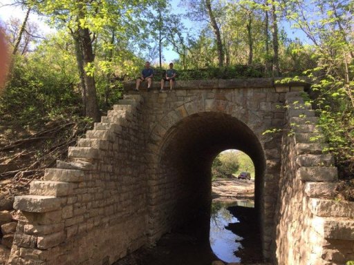
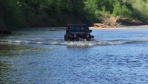
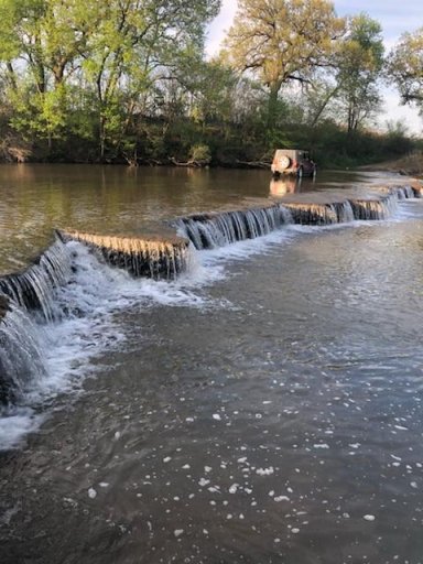
However, March is a little early. I made the trip first weekend of May with a couple guys and it was perfect. Bugs we're minimal and the temperature was beautiful.View attachment 80915 View attachment 80916 View attachment 80917
Wow.... we are still talking about the flint hills trail that you guys mapped out right?However, March is a little early. I made the trip first weekend of May with a couple guys and it was perfect. Bugs we're minimal and the temperature was beautiful.View attachment 80915 View attachment 80916 View attachment 80917
Holy smokes dude that looks awesome! I'm so pumped now!Pics were from nearby areas not directly on the trail.
BikeHauler was able to get out and confirm the part of the trail I was unsure of. So here it is.
The northernmost point starts at a KDOT station just of I70 (safe area to leave a vehicle). Then wanders down to Strong City/Cottonwood Falls (check out the Ad Astra restaurant if you swing through). Be sure to get gas in Cottonwood falls. The only other gas station is in Cedar Vale. The trail ends at a free camping area on the SE side of Cedar Vale.
I've been using gaia gpsWhat pro
What program are you using? I've tried to download and it doesn't open. I have two programs that open .kmz files, but it won't open. Can you take a screenshot and post it?


.jpg")
.jpg")