
Yes, you could download the maps to be available offline. However, i would check and see if your iPad has GPS(I'm not familiar with tablets, so I don't know..., if it doesn't have mobile data it might not have gps. But idk.)So if I had a iPad that doesn't have cell service I could download the app and download all the maps on wifi and will have them available to use on the go?
GPS options?
- Thread starter FreelandRyan
- Start date
You are using an out of date browser. It may not display this or other websites correctly.
You should upgrade or use an alternative browser.
You should upgrade or use an alternative browser.

So if I had a iPad that doesn't have cell service I could download the app and download all the maps on wifi and will have them available to use on the go?
Yes, however, the iPads without the cell chip have no GPS. So, even if you have the maps the app itself has no way of knowing where on those maps it is. So no positional plotting or real time trip data.


Off-Road Ranger III
There is an important distinction on iOS devices here. If you have an iPhone or iPad with just wifi you do not have a GPS chip in the device. You need a device that **can** have a SIM card installed to get "off the grid" location updates for Gaia or any other GPS apps. That said, as others have phoned out, you do not actually need to have a SIM card in the device.
If you have a wifi-only device you can use an external Bluetooth gps to get all the same features. And, sometimes with better accuracy.
Here is one I really like.
http://bad-elf.com/collections/bluetooth-gps
If you have a wifi-only device you can use an external Bluetooth gps to get all the same features. And, sometimes with better accuracy.
Here is one I really like.
http://bad-elf.com/collections/bluetooth-gps

Influencer III
- 5,079
- First Name
- Drew
- Last Name
- Hawley
- Member #
1537
- Ham/GMRS Callsign
- WRBZ674
- Service Branch
- USN veteran
 Since apparently nobody else uses Scenic Map I thought I'd show a screen grab so people can see how awesome the 3D topo maps are. The views are infinitely adjustable via pinch/slide/twist and can also be viewed as satellite images. The only downside I see to the app is is the sheer size of the maps. I purchased the US map bundle for I think $20 and it includes east, central, west, and Alaska maps. Total size is nearly 9 gigs with all 4 installed.
Last edited:
Influencer III
- 5,079
- First Name
- Drew
- Last Name
- Hawley
- Member #
1537
- Ham/GMRS Callsign
- WRBZ674
- Service Branch
- USN veteran
Here's a 37 second video from Scenic Map showing parts of the Grand Canyon but with satellite imagery.


Pathfinder II
I use BackCountry Navigator PRO. I like it a lot more than Gaia (which I also purchased first ,but kinda wish I hadn't). I just tried Gaia again, and confirmed I still like BCN (which isn't perfect either). The resolution & zooming are a lot better in BCN, I think. BCN has a ton of waypoint symbols - as far as I can see there is only one symbol for Gaia. I use different symbols for campsite, potential campsites, road junctions, picnic lunch, etc. BCN lets you select multiple tiles to download at one time; Gaia only lets you select one area at a time, download, then go back and select another area. However, sometimes BCN is painfully slow in downloading. For something I use every time I hit the trail, it was worth it to try both - they don't cost that much for what they do.
By the way, I use my Samsung 12.2" TabPro with a 64GB SD card which lets me be zoomed in but still see the big picture. A lot easier to see while driving. WAY better than using my Samsung S5 . It fits in a backpack easily too, so no problem there.
By the way, I use my Samsung 12.2" TabPro with a 64GB SD card which lets me be zoomed in but still see the big picture. A lot easier to see while driving. WAY better than using my Samsung S5 . It fits in a backpack easily too, so no problem there.
Last edited:
I use BackCountry Navigator PRO. I like it a lot more than Gaia (which I also purchased first ,but kinda wish I hadn't). I just tried Gaia again, and confirmed I still like BCN (which isn't perfect either). The resolution & zooming are a lot better in BCN, I think. BCN has a ton of waypoint symbols - as far as I can see there is only one symbol for Gaia. I use different symbols for campsite, potential campsites, road junctions, picnic lunch, etc. BCN lets you select multiple tiles to download at one time; Gaia only lets you select one area at a time, download, then go back and select another area. However, sometimes BCN is painfully slow in downloading. For something I use every time I hit the trail, it was worth it to try both - they don't cost that much for what they do.
By the way, I use my Samsung 12.2" TabPro with a 64GB SD card which lets me be zoomed in but still see the big picture. A lot easier to see while driving. WAY better than using my Samsung S5 . It fits in a backpack easily too, so no problem there.
Some of the things you have mentioned are supported in GAIA Pro. Layers allow you to download multiple map types at once and choose the percentage viewable. Different waypoint symbols are also supported in GAIA Pro. I am not saying it is better or worse. I just want folks to understand these options exist via a GAIA Pro subscription service.
https://www.gaiagps.com/gaiapro/#/overview

Enthusiast II
So if I had a iPad that doesn't have cell service I could download the app and download all the maps on wifi and will have them available to use on the go?
Correct
Pathfinder II
You are correct - thanks for clarifying about Gaia Pro. However, the cost for subscribing to Pro to get these added features in Gaia is $6 per month or $40 per year. . This is after purchasing the app for $20. BCN is $12 to purchase with no subscription for extra features. You can purchase extra specialized maps if desired (I purchased the BLM overlay map for $10), but the good basic USGS maps are free.Some of the things you have mentioned are supported in GAIA Pro. Layers allow you to download multiple map types at once and choose the percentage viewable. Different waypoint symbols are also supported in GAIA Pro. I am not saying it is better or worse. I just want folks to understand these options exist via a GAIA Pro subscription service.
https://www.gaiagps.com/gaiapro/#/overview
I'm not saying one is better than the other (I think Gaia might be more popular), but pointing out that there is a good, less expensive option to Gaia that I personally prefer after purchasing & using both. I like that there is a choice. Hopefully, this will help others find the program that best meets their needs. Either way, these are two great overlanding tools that don't require buying a dedicated GPS (which I've used for several years, but now lies unused).
I found this out after purchasing the app, but worth noting the Gaia pro version is free for outdoor volunteers and first responders including wildland firefighters, search and rescue, ski Patrol, volunteer scientists for the outdoors, etc. Info on their website at the bottom of the page
Influencer III
- 5,079
- First Name
- Drew
- Last Name
- Hawley
- Member #
1537
- Ham/GMRS Callsign
- WRBZ674
- Service Branch
- USN veteran


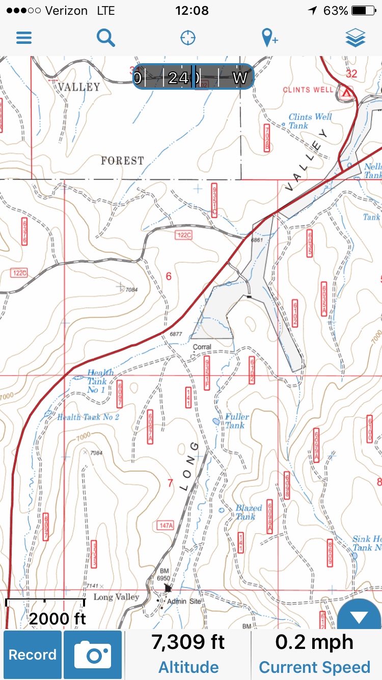
My question for Scenic Map is can it display the same forest road detail as a USFS Raster map?
Random example from GAIA
Took me a minute to locate the sample you were using as an example. Scenic map, admittedly, does not have all of the dashed lines (unmarked trails perhaps) that exist to some degree.
You are correct - thanks for clarifying about Gaia Pro. However, the cost for subscribing to Pro to get these added features in Gaia is $6 per month or $40 per year. . This is after purchasing the app for $20. BCN is $12 to purchase with no subscription for extra features. You can purchase extra specialized maps if desired (I purchased the BLM overlay map for $10), but the good basic USGS maps are free.
Also BCN is Android only. I have tried many apps and own many GPS apps. On iOS I have found Gaia to be the most robust and reliable. As mentioned it is not cheap if you want the Pro features. I typically do not use multiple layers although I will download them for just in case situations.
The new Hema application is a modified version of Gaia. There are a few exceptions and we will have to wait and see what future releases include. Layers seem to be free although I don't think they are working properly nor does the Hema app have USFS Raster maps which I find to be the most useful. The Hema road maps are nice but hey I don't really use this apps for being on pavement.
Competition is always good. I have been able to secure free 1 year pro subscription for Gaia for anyone that wants to give it a try. If you read my review of the app you can get one as well. http://www.4xoverlandadventures.com/navigation-app-choice-gaia-gps/
Pathfinder II
Competition is always good. I have been able to secure free 1 year pro subscription for Gaia for anyone that wants to give it a try. If you read my review of the app you can get one as well. http://www.4xoverlandadventures.com/navigation-app-choice-gaia-gps/[/QUOTE]
Nice review @1Louder. I just sent an email for the free subscription so I can try a fuller comparison on our upcoming trip in the Eastern Sierras/395. Nice website, too - I need to spend some time there!
Nice review @1Louder. I just sent an email for the free subscription so I can try a fuller comparison on our upcoming trip in the Eastern Sierras/395. Nice website, too - I need to spend some time there!
steven_cochran
Rank V

Influencer II
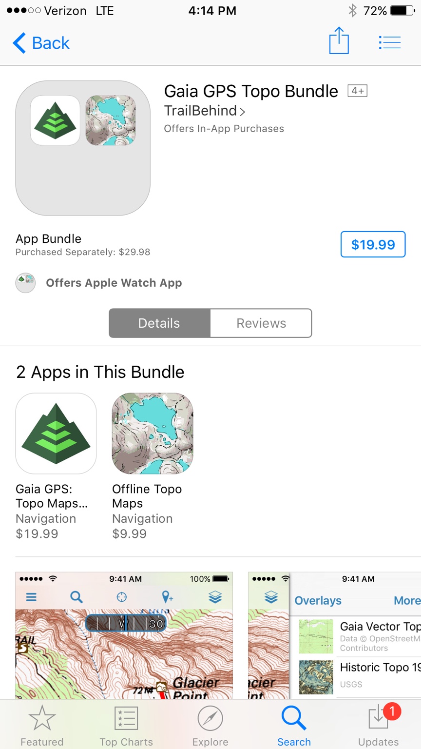
Is this a good deal?
Great deal. I woulda paid $100 for it knowing how great it is !
