Best Budget/Used Nav System for Beginner

  • HTML tutorial

Connor_Dobbins

Rank IV
Member

Enthusiast III

1,240
Northwest Chicago Suburb
First Name
Connor
Last Name
Dobbins
Member #

19373

Ham/GMRS Callsign
GMRS: WRHW455
I am fairly new to the whole Overlanding scene and was just using my phone's navigation with Google Maps a couple of weekends ago not expecting to lose connection as I was just in a slightly rural area of southern Wisconsin and I usually get good reception around there. But I lost connection and almost got lost but I managed. However this made me realize I should probably get a better offline always ready Nav system like a dedicated GPS or Tablet that using my phones GPS but then has the maps downloaded to the tablet.

My first thought was to use my Fire Tablet with Gaia GPS but the app proved to be slightly too much for the weak tablet to keep up with.

Now I am either looking for advice on either how to better use Gaia before I pay for the subscription or if there are any good Budget GPS units from companies like Garmin or if there are good older versions of their GPS units that I can find used on places like eBay. Anyone have good recommendations on budget GPS units, used ones to get or stay away from or should I just stick with my cheap fire tablet and Gaia?

EDIT: I should note that I would like to also have street navigation with this setup, whether that just means run Google Maps on the fire tablet as well or a GPS device that also includes street nav with the ability to import GPX files as well. But again street nav is not a deal breaker.
 

CTO1Mike

Rank VI
Launch Member

Traveler II

3,858
Yuba City, CA
First Name
Michael
Last Name
Lester
Member #

19079

Ham/GMRS Callsign
KC5DWF
Service Branch
Navy
My recomendation would be to find a cell capable referbished iPad and run Gaia. The iPad will allow you to do other things that a dedicated GPS cannot do.
So more bang for the buck. Many tasks, one device.
 

oldmopars

Rank V
Launch Member

Member III

2,865
Selah Wa
First Name
Scott
Last Name
Solomon
Member #

20486

I have 2 normal Garmin street style GPS, 1 Garmin Montana 610t, 2 iPhones and 1 iPad running Gaia.

Hands down the iPad running Gaia is my favorite for just exploring and playing in the woods. I need to learn it better and figure out what all it will do, but for now I really like it.
My Garmin Montana is great too, but it is more of a hand held unit. It is top of the line and has everything, more than I know what to do with. You can create tracks in Basecamp and down load them to follow and so for that it works good. However in a truck, the screen is just too small to really work well. However I do use it on my motorcycle all the time as the size is good for that.

You can use Gaia on your phone, and I can use it on my iPhone, but have not tried it. Again good for walking, but too small for driving. As for any on-line GPS app, useless once you leave civilization. Unless a tower is nearby they loose everything, and we want to go where there are no cell towers.

So, my vote is also for a iPad or other GPS tablet and use Gaia.
 

1Louder

Rank VI
Launch Member

Member II

4,187
AZ
First Name
Chris
Last Name
K
Member #

1437

Ham/GMRS Callsign
K1LDR
Besides paper maps as a back up to anything you choose I would add the Maps.me app and/or Pocket Earth to you phone. Both support offline maps. While they may not show your trail they will at least show the nearest marked roads and can help get you out of where you are.

As for budget what is yours? For some $100 is a lot of money. Others consider a $500 investment cheap. Someone just posted up a way to put topo maps on their older Garmin device. Maybe you can find one used cheap? I prefer my iPad and Gaia GPS. #BrokenRecord :)
 

Connor_Dobbins

Rank IV
Member

Enthusiast III

1,240
Northwest Chicago Suburb
First Name
Connor
Last Name
Dobbins
Member #

19373

Ham/GMRS Callsign
GMRS: WRHW455
My recomendation would be to find a cell capable referbished iPad and run Gaia. The iPad will allow you to do other things that a dedicated GPS cannot do.
So more bang for the buck. Many tasks, one device.
Yeah I am considering this! I just need a cell capable iPad, I don't need to get a data plan for the gps to work or do you need the data plan for the GPS to be activated?
 
  • Like
Reactions: Westsroadshow

CTO1Mike

Rank VI
Launch Member

Traveler II

3,858
Yuba City, CA
First Name
Michael
Last Name
Lester
Member #

19079

Ham/GMRS Callsign
KC5DWF
Service Branch
Navy
Yeah I am considering this! I just need a cell capable iPad, I don't need to get a data plan for the gps to work or do you need the data plan for the GPS to be activated?
No, the iPad will not need a data plan for the GPS chip to receive the satelite signals. The GPS signals will even be received while in air plane mode.
I tested that on a flight last month. I placed my ipad in air plane mode and pulled up Gaia. It located and tracked my position, as long as I was near a window.

Which is a note to keep in mind when using any GPS receiver, it has to have a clear view of the sky in order to receive GPS signals. (Box canyons and dense forests)
 

oldmopars

Rank V
Launch Member

Member III

2,865
Selah Wa
First Name
Scott
Last Name
Solomon
Member #

20486

Besides paper maps as a back up to anything you choose I would add the Maps.me app and/or Pocket Earth to you phone. Both support offline maps. While they may not show your trail they will at least show the nearest marked roads and can help get you out of where you are.

As for budget what is yours? For some $100 is a lot of money. Others consider a $500 investment cheap. Someone just posted up a way to put topo maps on their older Garmin device. Maybe you can find one used cheap? I prefer my iPad and Gaia GPS. #BrokenRecord :)
Paper maps and a compass would be the most Budget friendly way to go and is always a good idea as a back up. Big problem is that so few people can read a map. It is not taught in schools, most have learned it through military training or from Dad, Boy Scouts, etc. So, while having a paper map is a must have for me and just a great idea, if you can't read it, it is just more junk in the cab. Make sure you can read a map before going out. Basic map skills will get you a long way, you don't need to be a Navy Seal or Special Forces.
Batteries die, electronics fail, trees block GPS, a paper map never stops working.
 

AdamFineFJ

Rank I

Enthusiast I

I have a stack of maps in my rig as well as compass and even map protractors. I also have a garmin etrex 22x, a small handheld hiking/cycling unit. But I mostly use my old retired phone, a galaxy s7. No sim card in it. Just spotify and gaia.
I like using gaia and I prefer to keep the screen on so I use an old phone that's near permanently mounted on my dash and always plugged in. The battery is shot and barely lasts 2 hours by itself and the screen has ghost images of the keyboard burned into it with a magenta hue. BUT. It is cheap. It works. And does exactly what I need it to while driving offroad. I can connect to the wifi hotspot on my s10+ if I need to update it off cell towers. And any changes or routes or map downloads I make on my s10+ automatically get updated on my s7 when it sees wifi. If I need to see a large area I just zoom out, or out come the maps. I also have the REI National Parks app. I find it extremely useful for finding POI and services and finding the correct use of certain trails as I like to mountain bike and hike as well. I would say 95% of its use is just following a line and for that it is perfect for me. I much prefer to do my heavy duty route creation on a computer so I dont need a large screen.
 
  • Like
Reactions: Connor_Dobbins

Connor_Dobbins

Rank IV
Member

Enthusiast III

1,240
Northwest Chicago Suburb
First Name
Connor
Last Name
Dobbins
Member #

19373

Ham/GMRS Callsign
GMRS: WRHW455
@madcratebuilder @AdamFineFJ
I did not even think of using an old phone! That's not a bad idea I have an old Nexus 5x laying around that I forgot about! It will probably run better than my Fire tablet and that way I don't need to rely on my phones hotspot for GPS. Thanks for the idea!

Also @oldmopars I agree paper maps are a must as a back up! I remember always having them in the car when I was a kid and now no one seems to have them or even know how to use them! I do need to get some for the areas I live in and travel to. I know the basic skills on how to read them but honestly I have no idea where I picked those skills up from. I was never in Boy Scouts and I'm pretty sure my dad didn't teach me.[/QUOTE][/QUOTE]
 

Connor_Dobbins

Rank IV
Member

Enthusiast III

1,240
Northwest Chicago Suburb
First Name
Connor
Last Name
Dobbins
Member #

19373

Ham/GMRS Callsign
GMRS: WRHW455
No, the iPad will not need a data plan for the GPS chip to receive the satelite signals. The GPS signals will even be received while in air plane mode.
I tested that on a flight last month. I placed my ipad in air plane mode and pulled up Gaia. It located and tracked my position, as long as I was near a window.

Which is a note to keep in mind when using any GPS receiver, it has to have a clear view of the sky in order to receive GPS signals. (Box canyons and dense forests)
That's what I thought but I have never used a cell enabled iPad. I'll have to keep my eye out for a used one on eBay and stuff. It's ridiculous how much more Apple charges for the cell enabled ones compared to the wifi only models!
 

Connor_Dobbins

Rank IV
Member

Enthusiast III

1,240
Northwest Chicago Suburb
First Name
Connor
Last Name
Dobbins
Member #

19373

Ham/GMRS Callsign
GMRS: WRHW455
@Connor_Dobbins have you considered how you will communicate while out of cell range?
Yes! I have started to consider this and have started getting into HAM radio. I picked up a cheap Baofeng to mess around with. Still unlicensed but I'll probably be doing that this winter. Just trying to make sure that is the right option for me. From what I can tell it seems to be viable in the area I live in and camp in. There are that many repeaters but enough that I can reach if I get into trouble. I also considered FRS/GMRS to contact my parents if needed but the range is too low that it's not worth it unless they are camping with you. It's just a bummer that the only way to use a radio with a decent enough range is to take the Ham test.
 
  • Like
Reactions: CTO1Mike

CTO1Mike

Rank VI
Launch Member

Traveler II

3,858
Yuba City, CA
First Name
Michael
Last Name
Lester
Member #

19079

Ham/GMRS Callsign
KC5DWF
Service Branch
Navy
Yes! I have started to consider this and have started getting into HAM radio. I picked up a cheap Baofeng to mess around with. Still unlicensed but I'll probably be doing that this winter. Just trying to make sure that is the right option for me. From what I can tell it seems to be viable in the area I live in and camp in. There are that many repeaters but enough that I can reach if I get into trouble. I also considered FRS/GMRS to contact my parents if needed but the range is too low that it's not worth it unless they are camping with you. It's just a bummer that the only way to use a radio with a decent enough range is to take the Ham test.
I will highly encourage taking the Ham test. Think of the test as a small trail gate keeper. And it is not as difficult as some folks make out. With a bit of study, even using the test question pools that are on the market, pretty much anyone can pass the Tech exam. I personally need to study for my General license as I have been a Tech for almost 30 years! LOL Ham is a great community, a lot like Overland Bound.

Another consideration would be SATCOM such as the Iridium system. Garmin Inreach lets you text via satelite. But it costs.

The list:
1. GMRS - Short range
2. CB - slightly longer range than GMRS but low power limits
3. Ham - Longer range than CB and GMRS and Higher power limits, and repeaters
4. SATCOM - Anywhere in the world with a clear view of the sky, but costs money for a plan

Anyway, I hope my ramblings are somewhat helpful.
 
  • Like
Reactions: Turnerxc

Connor_Dobbins

Rank IV
Member

Enthusiast III

1,240
Northwest Chicago Suburb
First Name
Connor
Last Name
Dobbins
Member #

19373

Ham/GMRS Callsign
GMRS: WRHW455
I will highly encourage taking the Ham test. Think of the test as a small trail gate keeper. And it is not as difficult as some folks make out. With a bit of study, even using the test question pools that are on the market, pretty much anyone can pass the Tech exam. I personally need to study for my General license as I have been a Tech for almost 30 years! LOL Ham is a great community, a lot like Overland Bound.

Another consideration would be SATCOM such as the Iridium system. Garmin Inreach lets you text via satelite. But it costs.

The list:
1. GMRS - Short range
2. CB - slightly longer range than GMRS but low power limits
3. Ham - Longer range than CB and GMRS and Higher power limits, and repeaters
4. SATCOM - Anywhere in the world with a clear view of the sky, but costs money for a plan

Anyway, I hope my ramblings are somewhat helpful.
Yeah from what I have heard the test isn't that bad at all! I was also considering doing one of those "cram" classes, where an instructor teaches you the stuff you need to know to pass the test then directly after you take the test. Just need to find one near me.

I am also considering some form of SATCOM. Personally where I camp and explore there isn't much danger, and I don't do heavy off-roading. Being new to the whole scene I have been taking it slow and keeping risks way down. So as of right now SATCOM is kind of overkill but I will probably be getting some form of it soon.

I really wish Garmin built the Inreach functionality of text via satelite into the their new Overlander model instead they just advertise telling you to buy both.
 
  • Like
Reactions: CTO1Mike

1Louder

Rank VI
Launch Member

Member II

4,187
AZ
First Name
Chris
Last Name
K
Member #

1437

Ham/GMRS Callsign
K1LDR
Just remember a small handheld radio can’t reach very far. There may be repeaters in the area but you won’t be able to transmit to them. Anyway, that is ham stuff and there are other threads
 

Pathfinder I

1,685
Pacific Northwest
First Name
Steve
Last Name
Claggett
Service Branch
U. S. Army
Yeah from what I have heard the test isn't that bad at all! I was also considering doing one of those "cram" classes, where an instructor teaches you the stuff you need to know to pass the test then directly after you take the test. Just need to find one near me.

I am also considering some form of SATCOM. Personally where I camp and explore there isn't much danger, and I don't do heavy off-roading. Being new to the whole scene I have been taking it slow and keeping risks way down. So as of right now SATCOM is kind of overkill but I will probably be getting some form of it soon.

I really wish Garmin built the Inreach functionality of text via satelite into the their new Overlander model instead they just advertise telling you to buy both.
You can get a used Inreach for around $150, affordable but the monthly fee's can add up, at least you can do a month at a time. The BaoFeng BF-F8HP can reach repeaters, has good antenna upgrades for better range.
 

Connor_Dobbins

Rank IV
Member

Enthusiast III

1,240
Northwest Chicago Suburb
First Name
Connor
Last Name
Dobbins
Member #

19373

Ham/GMRS Callsign
GMRS: WRHW455
You can get a used Inreach for around $150, affordable but the monthly fee's can add up, at least you can do a month at a time. The BaoFeng BF-F8HP can reach repeaters, has good antenna upgrades for better range.
Yeah I figured an older used Inreach won't be that much but they are really for navigation which is why the Garmin Overlander would be the perfect companion for it! And I have the BaoFeng UV-5R 2nd gen just because it was
$23 so when I get my license I'll either get the BF-F8HP or a proper mobile setup for like $150. Then I have heard those can act as a sudo repeater to extend handheld units. But that will be further down the line.
 
  • Like
Reactions: Graeman

Graeman

Rank V
Launch Member

Off-Road Ranger I

2,876
Catalina Avenue, Tucson, AZ, USA
First Name
Todd
Last Name
Hoffmaster
Member #

4284

Ham/GMRS Callsign
KJ7CRJ
Service Branch
Air Force
Here is what I use when out on the trails. First off, I have a 2012 Jeep JK with the factory navigation system, a Garmin 62SC Handheld and iPad w/Gaia with premium subscription. The Garmin handheld is by far the very best at showing you where you are and what trails are near you. The screen is small and when driving it can get hard to read, but it will beep when a turn is coming up or if you miss the turn. The Jeep navi is great, it has most every major trail loaded into the system. It works on pavement, has a nice big screen and notifies you when to turn. The Gaia is good as long as there is constant power to the iPad - cause it will drain the battery in 2hrs. The maps need to be pre downloaded into the memory banks and you can not get near the USA borders and expect it to work properly. It doesn't beep or notify you of the turns, you can't type in direct me to Lake City, CO from Phoenix, AZ and have it get you there as easily as a factory car gps or google maps/ apple maps. I am still on the fence with my Gaia as it isn't capable of just grabbing your iPad and jumping into the Jeep and heading out to do a trail on a whim. To work properly it needs to have the trails pre downloaded.
So, a handheld in my opinion is the best dedicated get you there and back piece of equipment to own and only second to a good map/atlas. That is my Arizona opinion, maybe in other states Gaia works better, but not here.
 

1Louder

Rank VI
Launch Member

Member II

4,187
AZ
First Name
Chris
Last Name
K
Member #

1437

Ham/GMRS Callsign
K1LDR
The Gaia is good as long as there is constant power to the iPad - cause it will drain the battery in 2hrs. The maps need to be pre downloaded into the memory banks and you can not get near the USA borders and expect it to work properly.
What specific issue have you had on the border? I have never had an issue. Many trips and never an issue.

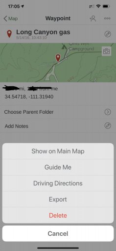
If you have a waypoint in Gaia GPS you can link out to Google Maps or Apple Maps for turn by turn directions. As Gaia was never meant to be that type of GPS app. Just tap the waypoint, then (i) and then the ... "button" on the top. (iOS)

A9E258C2-A165-4154-90F0-244C849F379A.jpeg
 
Last edited: