Don’t wait to chip away at this bucket list of overland destinations in the western US. Life’s short and this is only the first list of many recommendations coming your way.
Links to locations and trails will take you directly to the resource map in Overland Bound One. Be sure to download for iOS or Android for the best experience.
We’ve noted GPS coordinates and What3Word (///) locations for each point of interest.


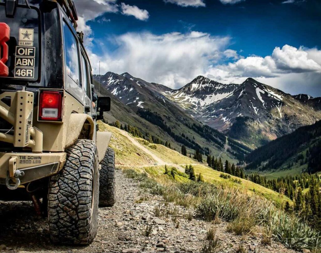
Big Bend National Park, Texas by Mick Haupt
01 Southwest Texas near Big Bend National Park
Why it’s on the List
There are few places in the United States where you’ll find more biodiversity than the Chisos Mountains and Chihuahuan desert surrounding Big Bend National Park in far west Texas. More than 1,200 species of plants, 450 species of birds, 56 species of reptiles, and 75 species of mammals call this corner of Texas home.
Of the 423 National Parks in the US, Big Bend is one of the most remote and least visited. There are more dirt roads than paved in the area, and the backcountry surrounding the park is a playground of off road exploration. Other region highlights include Big Bend Ranch State Park and Terlingua Ghost Town.
Best Time to Go
Late fall to early spring is an ideal time to check this one off the list. Remember this is the desert. The average summer temperature for the region is 83 degrees, but that’s in the shade. Around the Rio Grande, you should expect summer temps to climb well into the triple digits.
Options for Group Campsites and Dispersed Camping
There’s lots of dispersed camping along the River Road in the backcountry of Big Bend NP. Make sure you get a permit from a ranger station before heading out.
Rancho Topanga Campgrounds, Terlingua, TX
29.30326, -103.67956 | /// celebrated.photographed.bolsters
Roys Peak Vista Campsite, Big Bend National Park
29.38830, -103.07780 | /// putters.deposits.joystick
29.62140, -103.56890 | /// lorries.agency.perfected
Must Do Off Road Trails
Black Gap OHV Trail, Glenn Spring Road
29.13850, -103.11377 | /// gala.perceptual.upended
Difficulty Rating: Easy
Terlingua Ranch Road, Alpine, TX
29.61280, -103.14350 | /// leveraged.tint.lifts
Difficulty Rating: Moderate
Member Recorded GPX Tracks
@TXpedition through Big Bend National Park
29.54275, -104.32540 | /// showbiz.clenching.filaments
Difficulty Rating: Moderate

Silverton, Colorado on the Alpine Loop by Lucie Marchant
02 Alpine Loop, Colorado
Why it’s on the List
Alpine Loop (aka Alpine Loop Back Country Byway) is a 63 mile vehicle trail that connects the towns of Lake City, Ouray, and Silverton in southwest Colorado. While some of the Loop can be accessed by 2WD vehicles, you better have a 4WD rig to complete the entire trail. You can complete the main Loop in a day but there are also lots of side trails to explore. In your journey from base camp at 7700 ft. to the summit at 12,800 ft., you’ll enjoy high mountain passes, alpine tundra, mountain meadows, ghost towns, and relics of the silver mining era. Bonus: Alpine Loop is nicknamed “American Switzerland.”
Best Time to Go
You’ve got a very short window to check this destination off your list! Alpine Loop is only snow free and open to traffic from June through September.
Options for Group Campsites and Dispersed Camping
37.90659, -107.39056 | /// bells.yelling.wavelength
38.87145, -105.12057 | /// adventurer.duty.preferably
38.00594, -107.69234 | /// lollipop.spoken.decked
Must Do Off Road Trails
37.97940, -107.75910 | /// marshes.immaterial.intention
Difficulty Rating: Moderate
Black Bear Pass, Telluride, CO
37.89731, -107.72779 | /// successes.alarming.discuss
Difficulty Rating: Hard
Member Recorded GPX Tracks
@LifestyleOverland did the primary loop: 8 hours
37.93375, -107.56840 | /// tangible.prefect.lawyers
Difficulty Rating: Moderate

White Rim Road in Canyonlands National Park by Jorge Gonzalez
03 Southeast Utah near Canyonlands National Park
Why it’s on the List
Southeast Utah is heaven…or at least Mars. Utah is home to 5 national parks and the towering cliffs of red rock are the main attraction in the state’s southeast corner. Zion National Park in southwestern Utah is the state’s (and the country’s) most visited parks, and for good reason. But if you keep driving north on the 15 and then east on 70, you encounter the majestic “other” side of the state, home to Arches, Canyonlands, and Moab.
Best Time to Go
Spring or fall. Late summer and early fall visitors should expect afternoon thunderstorms.
Options for Group Campsites and Dispersed Camping
38.62111, -109.99976 | /// refresher.support.accepts
38.13626, -109.86024 | /// eating.raffle.triangular
38.17216, -110.46194 | /// holder.voters.careful
Must Do Off Road Trails
38.16900, -109.7605 | /// gross.refilling.richly
Difficulty Rating: Moderate
38.58335, -109.53089 | /// alpha.replicated.brightened
Difficulty Rating: Moderate
38.58226, -109.50709 | /// vitamin.including.condiment
Difficulty Rating: Moderate
38.45930, -109.79520 | /// hang.loops.luckily
Difficulty Rating: Moderate
Member Recorded GPX Tracks
@probablytheguy did Schafer Trail
38.47131, -109.81131 | /// streamline.gurgled.multiples
Difficulty Rating: Easy
38.60335, -109.70108 | /// experiments.generates.belongs
Difficulty Rating: Hard

04 Eastern Sierra, California
Why it’s on the List
The Eastern Sierra refers to the eastern side of the Sierra Nevada Mountains between the city of Lone Pine and the Nevada border. Covering roughly 24,000 square miles, the region includes world-class outdoor destinations including Mammoth Lakes, Bodie Ghost Town, Mono Lake, and parts of Yosemite and Death Valley National Park. If attractions aren’t your thing, the Eastern Sierra is also our favorite region for dispersed camping and 100% off-grid adventures.
Best Time to Go
As long as you’re prepared for sudden temperature and weather changes, you’ll have a great time visiting year-round. Winter is chilly and you might see snow and hail in the highest elevations. Take note that summers don’t get too hot (rarely above 90 degrees), which means it’s the most popular time for people to visit. Spring and fall are lovely and you’ll encounter fewer tourists.
Options for Group Campsites and Dispersed Camping
37.20120, -119.1300 | /// impresses.discoveries.menu
Big Springs Campground, Crestview
37.74857, -118.95046 | /// cuff.lighthouse.parsnips
37.07470, -119.15427 | /// grazed.hotdog.agriculture
Must Do Off Road Trails
37.61875, -118.90834 | /// countryside.wove.vessel
Difficulty Rating: Moderate
Kavanaugh Ridge and Dunderburg Mill
38.10370, -119.25088 | /// inherit.chaotic.brewers
Difficulty Rating: Moderate
Member Recorded GPX Tracks
@glacierdog did Mono Mills narrow gauge railway to Aurora, NV
37.89190, -118.95850 | /// jams.export.laundry
Difficulty Rating: Moderate
@TahoeTime did Bridgeport to Bodie Ghost Town via Chemung Mine
38.30890, -119.21111 | /// camps.inhabited.visited
Difficulty Rating: Easy to moderate

Oregon Wilderness by Makenzie Cooper
05 Oregon Back Country Discovery Routes (BDR)
Why it’s on the List
Oregon has it all. Moody coastlines, towering mountain ranges, high deserts, and canyonlands. The Oregon Off-Highway Vehicle Association designed off-highway routes throughout the state to help you see everything that Oregon has to offer. The main route is 1500 miles. You can do the entire trip in 6 discrete sections that are designed for off-road capable vehicles including trucks, ATVs, and motorcycles. The routes are intended to be self-supported backcountry trips so be prepared.
Best Time to Go
The routes open every year once snow has melted and close once snow begins again. Historically, June is the earliest that the routes open. Keep in mind that you’ll encounter mosquitos earlier in the season so don’t forget the repellant. If you go later in the fall, trails will be especially dusty.
Options for Group Campsites and Dispersed Camping
43.49470, -121.05680 | /// sights.diversions.luminosity
43.34607, -116.99733 | /// bloomers.bluntly.sensing
45.03704, -117.44641 | /// quail.coder.promotions
45.06560, -117.41023 | /// chances.drones.contraband
Must Do Off Road Trails
45.21224, -122.21316 | /// kilt.gambles.campaigning
Difficulty Rating: Easy, Moderate, Hard
45.60209, -123.33375 | /// divisional.verifying.cameras
Difficulty Rating: Easy
Member Recorded GPX Tracks
45.37010, -118.29738 | /// truthfully.fingertip.brains
Difficulty Rating: Easy
40.68352, -118.07042 | /// seamlessly.hinders.turns
Difficulty Rating: Easy
Add these bucket list destinations to your Overland Bound One offroad app and have a look around the area for dispersed camping sites, views/attractions, trails, gas stations, mechanics, medical care, and recorded tracks left by Overland Bound members.