The OFFICIAL Trans NJ Trail Thread

The last time I was able to do the full trail was late 2021, though I hit the Southern section often. I have made some comments here about changes to the trail, but I don't have the technical ability or knowledge to fix the route in the app.
 
The last time I was able to do the full trail was late 2021, though I hit the Southern section often. I have made some comments here about changes to the trail, but I don't have the technical ability or knowledge to fix the route in the app.
Thank you for your input. I need to have Leon show me how to edit the route
 
  • Like
Reactions: TSO_NJ
The last time I was able to do the full trail was late 2021, though I hit the Southern section often. I have made some comments here about changes to the trail, but I don't have the technical ability or knowledge to fix the route in the app.
Thank you for your input. I need to have Leon show me how to edit the route

I was able to add a “Caution Note” using the mobile app, but the icon has not appeared yet.

Hamp Road Bridge Closed Map.jpeg
 
Last edited:
  • Like
Reactions: MuckSavage
Correct me if I'm wrong, there's also a park in the Northern section that closes at dusk. And unlike the Southern sections there's actually a gate they put across the road. I ran into it a couple years back but I don't recall the exact spot. I went from High Point to Assunpink Lake in the first day and it was dark when I hit the gate, so somewhere in the Southern half of the Northern section.
 
Ran a short section this morning with @phillyphorester . Went from Whitesbog to Reed Rd. Trails are mostly dry, a few puddles with about 1/4inch or so of ice on top. There is currently a downed tree across the road at 39.934608, -74.421572 and of course it's the ONE day I don't have my chainsaw charged. :rage: 
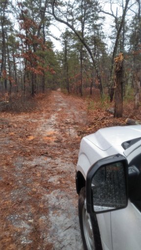
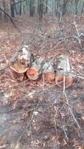
There was a side trail though so all is well.

For anyone willing to drive back out there, again coordinates are 39.934608, -74.421572
The tree is dead and snapped about 10 ft up and fell across the road, it's still attached at the top so it might need a tug first.

Screenshot_20240105_143221_Overland Bound One (1).jpgScreenshot_20240105_143202_Overland Bound One (1).jpg


Suspension full of ice shards.

20240105_112020.jpg

20240105_140720 (1).jpg
 
I did the entire route as posted in 2021 at least and it was all accurate. There is currently a bridge out as mentioned a few posts above but it only blocks a very short section of the trail. Some of the more North section of the trails are seasonally closed for Winter, best to wait until Spring.

Edit, sorry I replied faster than I can read. July will be fine, some of the lesser run trails will be overgrown with overhanging twigs but passable.
 
  • Like
Reactions: MuckSavage
Anyone want to run the full trail this spring? Myself in a 2021 Taco and my buddy in a street legal KTM dual sport are interested. Would be fun to caravan. Maybe make it a 2 or 3 day trip?
 
Anyone want to run the full trail this spring? Myself in a 2021 Taco and my buddy in a street legal KTM dual sport are interested. Would be fun to caravan. Maybe make it a 2 or 3 day trip?

I don't think I'll be able to stick around the whole time but I'd love to intercept you somewhere and finish the southern section. I need an excuse to go to Cape May again, haha.
 
Hey all! New here! I've been dying to take this trail, but curious if anyone has a trail traced on Google Maps or something similar. The above directions only shows as text when loading it into (crap) Microsoft word.
 
Hey all! New here! I've been dying to take this trail, but curious if anyone has a trail traced on Google Maps or something similar. The above directions only shows as text when loading it into (crap) Microsoft word.

You need to download the GPX file at the bottom of the first post and import it into an app like OnX Offroad or Gaia GPS
 
  • Wow
Reactions: jeepbecky
Hey everyone. I just joined the forum because I stumbled across this trail and am super interested in it. I have a stock 2002 Ram 1500 and have been wanting to get into some light off-roading / overlanding and I thought this would be a good "intro" if you will.
I told my wife and daughter about it and they are both super interested, so we are trying to figure out a time to make the run. If we do, we would do the full run over the course of a long 3-day weekend.

I will go poking around other areas of the forums as from a quick look it seems like there is going to be a lot of great information. However, for this trail, what would be a recommendation for what gear to have, aside from our camping gear, that may be necessary / useful? Or is the majority of this run pretty straightforward with no special equipment really necessary? From a couple of posts on here, I may pick up a battery chain saw as a just in case, but if anyone has a short list of "must haves", I am all ears.

Once I have a time-frame firmed up, I will post my dates here and maybe I will see someone else on the trail. Note: We would be going North to South.

Thanks in advance for any and all information.