The OFFICIAL Trans NJ Trail Thread

  • HTML tutorial

NJ-Surveyor

Rank III
Launch Member

Enthusiast II

539
Gloucester County NJ
First Name
Mike
Last Name
Zimmerman
Member #

24731

Ham/GMRS Callsign
KD2SVY
Thank you so much for creating this, i can't believe it took me so long to find it. I am looking forward doing this run this summer. I am located way down south So i will be starting from Cape May point and heading north. Super exciting! Xplorer313 if you are ever in south jersey and plan to stop at Glasstown Brewing Company please let me know and your beer is on me!
I grew up in Millville and just finished reconstructing the runway.
 
  • Like
Reactions: PGSIMMONS2

PGSIMMONS2

Rank III
Launch Member

Influencer II

770
10 Peterson Street, Millville, NJ 08332
First Name
Paul
Last Name
Simmons
Member #

11043

I'm in Millville often & I'm sure @Xplorer313 could be coaxed down as well! Could be an OB meetup with that ride out 49 to explore Tuckahoe WMA!
Definitely some good trails at the Tuckahoe WMA. There are quite a few trails just south of Millville too. If i get a chance over the next few days this weekend I will map and most them.
 
  • Like
Reactions: Jeepgirl69

Xplorr313

Rank V
Founder 500
Launch Member

Enthusiast III

2,421
Burlington, NJ
First Name
Leon
Last Name
Jones
Member #

0313

Ham/GMRS Callsign
WQYY816

Please sign petition to have the pine open to responsible Offroad access.
There is no need for this petition. Off-roading is already illegal in the Pine Barrens and will always remain illegal. If people would stop going out there acting like animals and acting like they can do whatever they want, there would be no issue.

My words of advice: stay on the roads, do not litter, do not rut out the roads, stay out of sensitive wetlands, if you see a sign that says no motorized vehicles OBEY IT!, respect the forests, and lastly..TREAD LIGHTLY.
 
  • Like
Reactions: MuckSavage

Cpol

Rank IX
Launch Member

World Traveler III

15,013
Jackson Heights, Queens, NY, USA
First Name
Chris
Last Name
Pol
Member #

14325

There is no need for this petition. Off-roading is already illegal in the Pine Barrens and will always remain illegal. If people would stop going out there acting like animals and acting like they can do whatever they want, there would be no issue.

My words of advice: stay on the roads, do not litter, do not rut out the roads, stay out of sensitive wetlands, if you see a sign that says no motorized vehicles OBEY IT!, respect the forests, and lastly..TREAD LIGHTLY.
We still need you to support the petition
 

Xplorr313

Rank V
Founder 500
Launch Member

Enthusiast III

2,421
Burlington, NJ
First Name
Leon
Last Name
Jones
Member #

0313

Ham/GMRS Callsign
WQYY816
I just wanted to say thanks @Xplorer313 for putting this together for everyone.

Is this trail okay to go alone? I have a Wrangler JLU, 35" tires, 2.5" lift and a winch if needed.
No problem!

It is ok to go alone, I went alone when I did the whole trail start to finish back in 2017. A lot can change since then. Be careful of water crossings. Be careful of mud holes. Some roads may have downed trees and you may need to take by passes. Just use your best judgement. I will say that the two water crossings in Brendan T Byrne on Glassworks Rd are deep as hell as of a few weeks ago. So deep that I didn’t risk crossing them in my JKU on 34s. Drive smart and you should be fine.
 

90volts

Rank II

Enthusiast III

473
Springfield, PA 19064, USA
First Name
mike
Last Name
gallela
I will say that the two water crossings in Brendan T Byrne on Glassworks Rd are deep as hell as of a few weeks ago. So deep that I didn’t risk crossing them in my JKU on 34s. Drive smart and you should be fine.

Saw some vids on youtube a while back and the route, then found this site the other day. Going to check out the route in more detail. I normally run around wharton, lebanon, penn state, etc... all that area. i found some high water a couple weeks ago myself. So when you say you wouldn't chance it... what is acceptable on your JKU? I am new to the wrangler and pretty new to offroad in general so still learning and wanted to see what was acceptable? up to bumper? top of tires, etc? I did get stuck in some mud over by Mount a few weeks ago, right of the Washington tpk.. Up just over the bumper. Thank goodness for the new winch which i have been wanting to try out. thanks for all the effort you put into the map!
 
  • Like
Reactions: TSO_NJ

Xplorr313

Rank V
Founder 500
Launch Member

Enthusiast III

2,421
Burlington, NJ
First Name
Leon
Last Name
Jones
Member #

0313

Ham/GMRS Callsign
WQYY816
So when you say you wouldn't chance it... what is acceptable on your JKU?
No problem! Honestly, if you don’t have a snorkel, nothing above the front bumper. Never splash through anything either. Always creep into it. The air box on the Wrangler is a horrible design that will suck in water faster than you’d think. Also, from what I heard, the fans and belt also like to sling water into the air box. Just things to be cautious of. Make sure your front diff, Trans/transfer case, and rear diff breathers are up high as well. It will help keep water out.

I’m sure you know this but just a reminder, never shut your engine off if you get stuck in a hole. And also never sit in your vehicle, while it’s running under water, for a long period of time. There has been people who have died from carbon monoxide poisoning due to this. If you’re by yourself and you’re stuck for a long period of time until help arrives, get out of your vehicle and wait.
 

Xplorr313

Rank V
Founder 500
Launch Member

Enthusiast III

2,421
Burlington, NJ
First Name
Leon
Last Name
Jones
Member #

0313

Ham/GMRS Callsign
WQYY816
84FEC3F2-DA9D-462A-A8D9-E5F7F4430C5B.jpeg

Also another good tip, hug either the left or right side of a hole...especially if you’ve never been through it or seen someone go through it before. The best decision you can make on which side to hug is A: know what side your air box is on, hug that side so you keep your air box high and dry. B: creep into it, if it starts to drop off suddenly, back out and go to the other side and try it. C: if both sides drop off suddenly, go slow into the center and see if it does the same. If it does, you have no choice but to go back to A and hope for the best.

Be warned, there are a lot of holes in the pine barrens that are extremely deep, I’ve seen trucks on 42s get stuck in some of the holes, especially the holes along the route going to Mount after leaving Batsto. If I remember correctly, I removed that section from the TNJT.
 

Xplorr313

Rank V
Founder 500
Launch Member

Enthusiast III

2,421
Burlington, NJ
First Name
Leon
Last Name
Jones
Member #

0313

Ham/GMRS Callsign
WQYY816
F745DCED-EAA7-4272-A004-2A25BBDBD55A.jpeg

Same hole. Notice how I’m keeping my air box higher than the driver side. It’s not a deep hole but when my buddy went through it first, it was up over his rear bumper of his Tacoma and he’s on 33s and 2” lift. He also wasn’t as hugged to the right like I was.
 

Forjas

Rank I
Launch Member

Contributor II

271
The World
First Name
Felipe
Last Name
Nascimento
Member #

15074

Special thanks to Xplorer313!! Would not have done it with out all the great work you did to put together the map!! Thanks man! And a shot out to my two new friends, RockU and Forjas, great guys!
What a bad friend I'm! Lol.
Went on the trip and dead silent afterwards =P. No pics, no videos... shame on me.

Huge thanks to @Xplorer313 on putting the trail together! It was an amazing trip especially meeting @RockU and @NYVenture mid-way! Will have to say that we went on our better judgement when coming to that water crossing!!

Well, I suppose is never toooo late for pics! Here they are!
I will post the videos soon also, just finishing up with some editing (I promise @RockU !)

20190525114228_IMG_2127.jpg
(The start point is already worthy of a breakfast / coffee stop)

20190525123128_IMG_2132.jpg
(First few miles are paved... didn't matter much with those views)

20190525130758_IMG_2133.jpg
(Sign should read: Watch out! Fun ahead!!)

GH010166.jpg
GH010166-1.jpg
GH010166-2.jpg
(And this is what that sign really meant!)


20190526093833_IMG_2137.jpg
(Next day the crew assembled together at the Wawa to get ready for some sand riding in the Pine Barrens)

GH010169-1.jpg
GH010169-7.jpg
GH010169-6.jpg
(This is what you can expect while offroading in the Pine Barrens. Watch out for those deep sand sections, because you are going to have loads of fun :)

GH010169.jpg
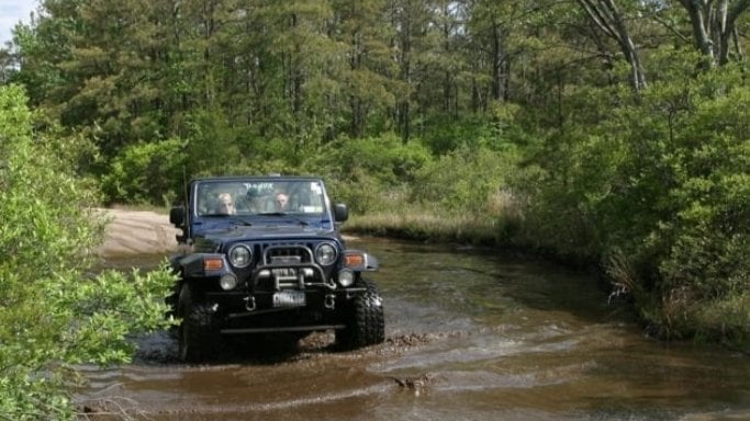
(You can't see much in the picture, but this is the section where the trail reads "DON'T PROCEED IF YOU DON'T HAVE A SNORKEL". The trail continues to the right and goes through deep water... after lots of conversation and a wet underwear - yeah @NYVenture sacrificed his underwear for the common good while walking the water crossing to check depth - we decided to not proceed. @NYVenture took the lead again and decided to go left instead since there was a trail there.... this where the fun starts).

GH010169-2.jpg
(After about 10 minutes we hear something over the radio, just a shutter. Apparently @NYVenture ran out of range and was trying to warn us about something... we couldn't hear crap and thought he was asking for help, so here goes Mr. Forjas to the rescue... well, you can see from the pic he needed no damn help and was trying to tell us the trail was pretty overgrown and got tighter and tighter! Well, time to drive in reverse for some time.... lol!)

GH010169-3.jpg
(and the end result)

GH010169-5.jpg
(you can see that to the right there is even more trails through deep water... well, we decided it was time to cut the day short and head back for some food!)

20190526180209_IMG_2141.jpg
(@NYVenture getting some burgers ready after a fun day)

20190526180231_IMG_2142.jpg
(We got a campsite close to a stream for dinner. We ended up circling the campsite 3 times to find our spots... maybe we were just showing off, maybe... ! Lol)
 

Xplorr313

Rank V
Founder 500
Launch Member

Enthusiast III

2,421
Burlington, NJ
First Name
Leon
Last Name
Jones
Member #

0313

Ham/GMRS Callsign
WQYY816
How can I open this GPX files with a Windows PC ?

I am from the West Long Branch area and would love to do part of this trail with you people.
You need to load it into a gps device/system/or app. You will not be able to see the route on your PC. The best solution I can give you is to load the file into Google Maps.

Go to google.com, click on maps, click the menu and choose “your maps”. Choose to create a new map, and then load the file into Google Maps. That’s about it.
So far no luck with Google Earth or Map. I did find an App on the Google Play Store. I will try it tonight. If any of you are doing something in or near New Jersey please let me know.

Thanks for getting back for quickly. Look forward to meeting up with the group.

Later
Nick Mannarino
 

Xplorr313

Rank V
Founder 500
Launch Member

Enthusiast III

2,421
Burlington, NJ
First Name
Leon
Last Name
Jones
Member #

0313

Ham/GMRS Callsign
WQYY816
So far no luck with Google Earth or Map. I did find an App on the Google Play Store. I will try it tonight. If any of you are doing something in or near New Jersey please let me know.

Thanks for getting back for quickly. Look forward to meeting up with the group.

Later
Nick Mannarino
Download the file from the first post in this thread.

Go on google and search “free GPX to KML converter”

Open the webpage and load in the GPX file. Convert and then save it.

Now try to load the KML file into google earth or google maps. It should work.
 
  • Like
Reactions: MuckSavage

Forjas

Rank I
Launch Member

Contributor II

271
The World
First Name
Felipe
Last Name
Nascimento
Member #

15074

Download the file from the first post in this thread.

Go on google and search “free GPX to KML converter”

Open the webpage and load in the GPX file. Convert and then save it.

Now try to load the KML file into google earth or google maps. It should work.
Use this website to convert the file and follow Xplorr313 instructions:

 
  • Like
Reactions: Xplorr313
Use this website to convert the file and follow Xplorr313 instructions:

Use this website to convert the file and follow Xplorr313 instructions:

OK I found an app in the Google Play store that worked. I see the map point red flags and the trails/roads. Not all of them are named, would this be right?

Thanks again for all the help with this.