** This is not all the pictures. Just some of the ones I have loaded up**
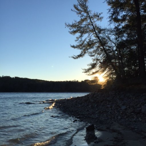
8FEB17- Wednesday I got off work and made a few last minute stops before I made it to Devils Fork State Park in Salem, SC. I ended up making it to the campground around 9 pm and set up camp. Just about an hour later my good friend and his wife showed up, and I helped them set up camp. We cracked open a few beers to talk over the trip and in specific the next day and what we would face along the way. Offroading was very new to them and I didn't want them to feel pushed into any situation. So a few beers led to a few more. It started pouring down rain so We huddled under my roof top tent for some shelter until the rain slowed down.
Wednesday night set up:

9FEB17- Thursday morning started off earlier than I had planned. 4 am I woke up to the tent awning flapping due to the winds pulling up the guy-line pegs. So I got up and temporarily fixed it and went back to bed. Around 7 am we all got up, cooked some breakfast, and I flew the drone a little bit until I got a high wind advisory. I could have easily kept flying it but I didn't want to risk my new toy.


Drone pictures:

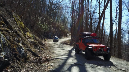
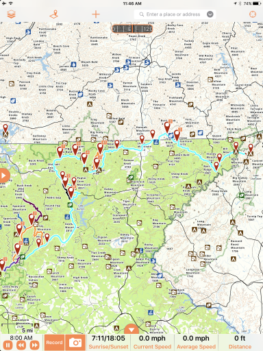
We left Devils Fork Campground and headed to Burrells Ford Road, the start of the Georgia Traverse. The total mileage of Day 1 on the Georgia Traverse was 86.3 miles. We averaged a speed of 13.3 mph and a moving average of 19.7 mph. These averages include both offroad travels and pavement travels since there are sections of pavement as part of the Georgia Traverse. The road conditions were in good shape, there were some trees down throughout the entire day but these roads seemed to be traveled a decent bit before we passed because the trees were cleared from the trails. I think the highlight of this day was when we crossed the Tallulah River, and I was able to get the drone out and get some pretty cool footage. I will go ahead and let you know that I am very very new and inexperienced with the DJI Mavic Pro. Now keeping that in mind, later on down the trail, the drone had a near death experience while we were trying to get some trail footage. I was trying to show Chris and Lauren the "auto land" feature and the drone decided to fly back to the home location. I didn't realize it at the time and let me tell you. HEARTATTACK!
Tallulah River crossing pictures from Drone:


Trail footage that almost lead to the death of my drone:


Through out the day the trails were consistently dry with no need for 4WD.
More write up to come about the trip! I've got to head back to work.
8FEB17- Wednesday I got off work and made a few last minute stops before I made it to Devils Fork State Park in Salem, SC. I ended up making it to the campground around 9 pm and set up camp. Just about an hour later my good friend and his wife showed up, and I helped them set up camp. We cracked open a few beers to talk over the trip and in specific the next day and what we would face along the way. Offroading was very new to them and I didn't want them to feel pushed into any situation. So a few beers led to a few more. It started pouring down rain so We huddled under my roof top tent for some shelter until the rain slowed down.
Wednesday night set up:
9FEB17- Thursday morning started off earlier than I had planned. 4 am I woke up to the tent awning flapping due to the winds pulling up the guy-line pegs. So I got up and temporarily fixed it and went back to bed. Around 7 am we all got up, cooked some breakfast, and I flew the drone a little bit until I got a high wind advisory. I could have easily kept flying it but I didn't want to risk my new toy.
Drone pictures:
We left Devils Fork Campground and headed to Burrells Ford Road, the start of the Georgia Traverse. The total mileage of Day 1 on the Georgia Traverse was 86.3 miles. We averaged a speed of 13.3 mph and a moving average of 19.7 mph. These averages include both offroad travels and pavement travels since there are sections of pavement as part of the Georgia Traverse. The road conditions were in good shape, there were some trees down throughout the entire day but these roads seemed to be traveled a decent bit before we passed because the trees were cleared from the trails. I think the highlight of this day was when we crossed the Tallulah River, and I was able to get the drone out and get some pretty cool footage. I will go ahead and let you know that I am very very new and inexperienced with the DJI Mavic Pro. Now keeping that in mind, later on down the trail, the drone had a near death experience while we were trying to get some trail footage. I was trying to show Chris and Lauren the "auto land" feature and the drone decided to fly back to the home location. I didn't realize it at the time and let me tell you. HEARTATTACK!
Tallulah River crossing pictures from Drone:
Trail footage that almost lead to the death of my drone:
Through out the day the trails were consistently dry with no need for 4WD.
More write up to come about the trip! I've got to head back to work.