OB Approved Basic Map and Nav

  • HTML tutorial

Dunco

Rank VI
Launch Member

Off-Road Ranger I

3,346
Warwick Queensland Autralia
First Name
Kris
Last Name
Duncan
Member #

0787

Ham/GMRS Callsign
VK4FABX
Definition of a Map…
•Its a scaled representation of the earths surface shown on a plane surface.
•It shows natural and/or artificial features.
•Used as a form of communication, used to convey land features.
•However, its only accurate at time of aerial photo or field revision.

Map Types
•Street directory
upload_2016-1-17_17-9-1.png
•Topographic map
upload_2016-1-17_17-9-31.png

•Mud
•Scientific

Map Info
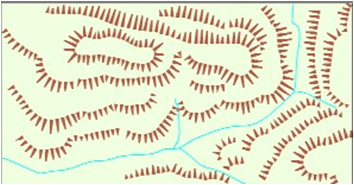
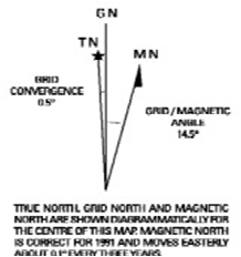
•Map info is printed around the margin of the map to aid in using the map it contains the map Title, scale, type, legend of symbols, edition & sheet number, adjoining maps, contour interval, magnetic variation, grid reference block
upload_2016-1-17_17-11-22.png

Mapping Datum
•All mapping & coordinate systems are based on a datum
•It’s a mathematical surface (overlay) that best fits the shape of the earth
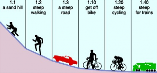
Map Scale
Scale on a map is expressed in 3 methods.
1.In words (One cm = One km)
2.Representative fraction. (RF)
1:25000 E.g 1cm = 25000cm or 250m.

TRICK - REMOVE LAST 2 ZEROS TO GET

ACTUAL SIZE ON GROUND IN METRES
1:10,000 to 1:100,000 are small scale
1:250,000 to 1:10 million are large scales

3.Linear scale - scaled ruler.
upload_2016-1-17_17-38-48.png

Measuring Distance
•Measuring straight line distance (map)
–Paper
–Divider
–Ruler
upload_2016-1-17_17-39-57.png

•Measuring distance along a road/track (map)
–Curved paper
–Length of string
upload_2016-1-17_17-42-11.png

Map Coordinates
•2 Types
–Geographical coordinates given as latitude and longitude
–Grid coordinates given as Eastings & Northings

Latitude & Longitude
•Uses degrees, minutes, minutes
–Each degrees & minutes is divided into 60 graduations
•Horizontal lines (Parallels of latitude)
–(N or S of equator)
•Vertical lines (Meridians of longitude)
–(E or W of Greenwich)
S310 51’ 0” E1150 54’ 3”

Grid Coordinates
•Used to accurately locate/position objects on a map.
•Two sets of numbered parallel lines (vertical & horizontal) intersecting at right angles to form squares on a map.
•Superimposed over the map to provide a reference system.
•Grid squares are generally 1km2.
•Grid lines are defined as ‘Eastings’ & ‘Northings.’
•Eastings are the vertical lines, numbered left to right.
•Northings are the horizontal lines numbered bottom to top.
•Read ‘Eastings’ first, then ‘Northings’.

4 Figure Area References

•The co-ordinates represent the whole square, not just the single point.
E.G 1844 - represents 1km2
•Find ‘18 easting’ first.
•Find ‘44 northing’ second
maxresdefault.jpg
 
Last edited:

Dunco

Rank VI
Launch Member

Off-Road Ranger I

3,346
Warwick Queensland Autralia
First Name
Kris
Last Name
Duncan
Member #

0787

Ham/GMRS Callsign
VK4FABX
Ground Shape…
•Allows the user to visualise the surroundings
•Ground shape is referred to as relief.
•Relief can be shown as:
–Hachures
–Hill shading &
–Contours

upload_2016-1-17_18-8-14.png
upload_2016-1-17_18-8-26.png

Contours…
A contour is a line that joins points of equal elevation
Contour interval is the vertical distance between contour lines
•See legend for contour interval
upload_2016-1-17_18-10-2.png
Contour Patterns…
•Contour lines close together show steep slopes
•Contour lines far apart show gentle slopes
•Contour lines evenly spaced show uniform slope
•If the spacing decreases when going from high to low, the slope is convex
•If the spacing increases when going from high to low, the slope is concave
upload_2016-1-17_18-11-13.png
Land Features…
•Representation of height
–Bench mark, trig station, spot height
•Physical features
–Knoll
–Saddle
–Spur, ridge
–Valley, gorge
–Escarpment
–Re-entrant
–Crest
–Plateau
upload_2016-1-17_18-12-28.pngupload_2016-1-17_18-12-42.png
Gradient…
•A method of expressing ground slope.
•Gradient = Contour interval (height)
Horizontal Distance
1:10 = 1 unit up or down / 10 units across.
1:1 is a 450
Simplify to smallest fraction = 20 = 1 = 1:6
120 6
upload_2016-1-17_18-15-7.png

Intervisibility – Line of sight
•Used to determine the location of radio repeaters (particularly VHF) & fire lookout towers

upload_2016-1-17_18-16-2.png
 

Attachments

Dunco

Rank VI
Launch Member

Off-Road Ranger I

3,346
Warwick Queensland Autralia
First Name
Kris
Last Name
Duncan
Member #

0787

Ham/GMRS Callsign
VK4FABX
Compass…
•Degree system - (3600 circle)
–North = 0/3600
–South = 1800
–East = 900
–West = 2700
•Cardinal points
–32 in total,
–only 16 are used.
upload_2016-1-17_18-18-37.png

Bearings…
•The purpose of a bearing is to give an accurate indication of direction from one point to another.
•Simply, a bearing is an angle.
•It is the angle measured clockwise from a fixed zero line, generally north.
•Grid bearings
–Used when bearings are taken from or to the map.
•Magnetic bearings
–Used in conjunction with a compass. This type of bearing is for field operation.
•Bearings are measured using a protractor or compass.

North Points…
•True north - TN
–Earth spins on this axis
•Magnetic north - MN
–Compass needle points to magnetic north
–Its a location in the far north of Canada
•Grid north – GN
–The vertical lines overlayed on a map point to grid north – (eastings)
–Not exactly true north.
–Difference between TN & GN is called convergence
•In map reading we only use GN & MN

Magnetic Variation…
•The difference between ‘grid north’ & ‘magnetic north’ is called magnetic variation.
•The magnetic north pole is not fixed, it moves continually
•Easterly & westerly variation
•Check map for accuracy of variation
upload_2016-1-17_18-22-50.pngupload_2016-1-17_18-23-45.png

Converting Bearings
•Mag’ bearings must be converted to Grid bearings for plotting.
•Grid Bearings taken from map must be converted to Mag’ for compass work
•To convert bearings – simply add or subtract variation
GMS = Grid to Magnetic – Subtract (GrandMaSux)
MGA = Magnetic to Grid – Add (My Green Apple)
•Grid bearings are always larger than a magnetic bearing with an easterly variation

Back Bearings
•A back bearing is the bearing immediately opposite the current bearing
•Add 1800 if bearing is smaller than 1800
•Subtract 1800 if bearing is larger than 1800
•Reversing compass
upload_2016-1-17_18-26-5.png


upload_2016-1-17_18-26-18.png

Compasses…
•Many types & shapes.
–Prismatic, reflective & Silva
•Consist of
–Magnetised needle
–A non ferrous or plastic box
–A graduated 3600 circle and
–Sometimes an aiming point
upload_2016-1-17_18-27-24.pngupload_2016-1-17_18-27-35.pngupload_2016-1-17_18-27-44.png

Parts of a Compass…
•Silva Compass
upload_2016-1-17_18-28-49.png
 

Attachments

Dunco

Rank VI
Launch Member

Off-Road Ranger I

3,346
Warwick Queensland Autralia
First Name
Kris
Last Name
Duncan
Member #

0787

Ham/GMRS Callsign
VK4FABX
•Prismatic Compass
upload_2016-1-17_18-30-34.png


Taking a Grid Bearing…
•Using a compass & map.
–Place edge of compass along intended bearing.
–Direction arrow points the way you want to travel
–Turn housing so meridian lines are parallel to easting lines
–Read grid bearing where housing and index intersect
Note: This bearing must be converted to mag’ bearing if intended for field use.
upload_2016-1-17_18-31-34.png

Magnetic Bearings
•Setting a Magnetic bearing
–Hold compass flat in palm
–Set bearing on compass by rotating housing
–Turn yourself till red needle lines up with north
–Now walk in direction of directional arrow
•Taking a Magnetic bearing
–Hold compass with directional arrow pointing at intended object/direction
–Rotate housing till north aligns with red arrow
–Read bearing where index lines intersects
•Compass back bearings
–Face the opposite direction, turn compass around & walk with directional arrow pointing towards you.
–Or use white needle as directional indicator
•Compass Error
–Individual compasses
–Local magnetic attraction due to steel/iron ore
•Transmission lines = 80m
•Car = 60m
•Wire fence = 10m
•Pick, Axe or shovel = 3m
 

Dunco

Rank VI
Launch Member

Off-Road Ranger I

3,346
Warwick Queensland Autralia
First Name
Kris
Last Name
Duncan
Member #

0787

Ham/GMRS Callsign
VK4FABX
Cross-country Navigation
•Factors influencing C-C navigation
–Weather, terrain, vegetation, visibility
–Team composition, fatigue
–Access restrictions, boundaries, route choice
•Improvised direction finding
–By shadow stick & sun
–By the stars
–By using a watch & sun
–Bushman's method – kangaroos
–GPS
upload_2016-1-17_18-37-18.pngupload_2016-1-17_18-37-57.png

•Predicted walking time
–5km/hr easy going
–3km/hr easy scrambling
–1.5km/hr rough country, snow, sand or thick bush
–Add 1hr for every 500m up or 1000m down
–Every 5 hrs allow an 1hr for fatigue.

•Distance travelled - pacing & time
–Average step is 75cm
–Approx’ 650-660 right steps = 1km

•Judging distance - See Learners Guide for object sizing P79
–Unit of measure (Good up to 400m – Sports fields or swimming pools)
–Appearance (Takes a lot of practice – compare with surroundings)
–Bracketing (Greater than 200m, Less than 600m)

Planning…..
•Route planning – Map study
–Essential, you must have a good plan before setting off.
–Have an alternate plan & route
–Break route down into individual legs.
–Each leg should terminate at recognisable objects or within an hour
•Consider
•Grain of country
•Ridges
•Rivers
•Dense scrub
•Access
Map Orientation
•A simple way to read a map is to orientate the map to its surroundings.
•Using land features
–Lay the map on the ground. Rotate map till features on ground align with those on map.
•Using a compass (grid)
–Determine & set mag’ variation on compass
–Align compass edge with ‘N-S’ meridian lines
–Rotate map & compass till compass needle is aligned
upload_2016-1-17_18-41-16.png
•Using a compass (mag)
–Draw mag’ variation lines on map
–Set compass to mag’ ‘N’
–Align compass edge with drawn lines
–Rotate map & compass till compass needle is aligned
–All compass bearings can now be taken directly from the map
Lateral Drift
•Is when you drift away from the given destination, but you remain on the same bearing.
•The compass alone, is not enough to eliminate lateral drift.
•Spot a feature (tree, knoll) on the set bearing, walk to that feature, then reassess. Continue until destination is reached.
upload_2016-1-17_18-42-51.png
Avoiding an Obstacle
•Used to traverse around cliffs, knolls, swamps etc
•Pacing at 900 intervals
•Leg 1 and 3 need to be of equal distance
upload_2016-1-17_18-43-53.png

Position Fixing – Resection
•Used when you’re unable to fix your position from the ground to that on the map.
•Find 2 or 3 prominent features.
•Take magnetic bearing of features & convert to grid bearing.
•Change to back bearing & plot all bearings on map.
•Your position is where the back bearings intersect.
upload_2016-1-17_18-45-14.png


Action If Lost!!!
•Don’t PANIC, remain calm
•Re-think route & confirm ground covered
•Position fixing -resection
•Identify a bearing (track junction) & head for safety
•Unable to identify your position, set up camp & wait for rescue
Initiate any distress beacons
Shout out to Dave for helping with content
 
Last edited:

Steve

lost again...
Founder 500
Launch Member

Traveler III

4,312
Lorain County, OH, USA
First Name
Steve
Last Name
None
Member #

202

Very, very nice, @Dunco! Definitely a good candidate for a Boot Camp posting. It almost could be two separate tutorials, one on mapping and one on compass use, although in reality, they both need to work together.

Thanks for putting this together!
 

rixham

Rank V
Launch Member

Off-Road Ranger I

2,898
Frederick, MD
First Name
Robert
Last Name
Rixham
Member #

1093

Ham/GMRS Callsign
KC3NAZ
Excellent topic!

I knew much of this from my time at the USAF Survival School.. There was a lot of new or refresher information. It just goes to show, if you don't use it, you lose it.

Again, great job!