Maybe you can help me with this. I was out and about in the sierras decided to take the trail up to central camp above bass lake. Ontne way up part of my screen went blurry the other part not. Not so blurry you couldn’t make out any thing but enough that you could recognize trails topo lines etc but couldn’t distinguish anything I was just running it on my iPhone 11 and the transfer to the jeeps main screen I was pretty sure I had downloaded the whole area awhile back I think I had the usgstopomap running as a base and not the Gaia base . I dint think much about it then but could that have been the problem?
Ask About Gaia GPS!
- Thread starter 1Louder
- Start date
You are using an out of date browser. It may not display this or other websites correctly.
You should upgrade or use an alternative browser.
You should upgrade or use an alternative browser.

Maybe you can help me with this. I was out and about in the sierras decided to take the trail up to central camp above bass lake. Ontne way up part of my screen went blurry the other part not. Not so blurry you couldn’t make out any thing but enough that you could recognize trails topo lines etc but couldn’t distinguish anything I was just running it on my iPhone 11 and the transfer to the jeeps main screen I was pretty sure I had downloaded the whole area awhile back I think I had the usgstopomap running as a base and not the Gaia base . I dint think much about it then but could that have been the problem?
Change the layers to see which one was not downloaded fully. That’s the easiest way to correct things. I recommend downloading an entire State with the Gaia Topo layer. The file size is reasonable. Then you know you have at least one map layer with coverage.
If you saved a set of layers you can always see that under the Saved tab. Find what you saved, say Blah Lake, for example and the click the show on main map button. That should force everything you downloaded to display.
It sounds like you had a layer either not downloaded at all or not completely downloaded. What you were seeing was the cached data in Gaia. It got blurry when you ran out of cached data. You can always clear your cache, set your phone I. Airplane mode with WiFi off and then check your maps again.

Has anyone else noticed that Gaia has killed the 5-year plan? My three month trial just ended today and I was going to do the five-year. But as far as I can tell, it's not available anymore. Which is a bummer. I wanna say the five year with a coupon was under $100 and the one year is closer to $40/year (yeah I can get a coupon for ~$35 he first year but who knows what the price will be next year) . A significant difference. I'm kinda wondering why/if Gaia lost confidence in the five-year option.

Influencer III
- 4,312
- First Name
- Rex
- Last Name
- Drake
- Member #
19540
- Ham/GMRS Callsign
- KI5GH
- Service Branch
- Air Force
Gaia was recently acquired, so I’m guessing the new owners are recouping their investment.Has anyone else noticed that Gaia has killed the 5-year plan? My three month trial just ended today and I was going to do the five-year. But as far as I can tell, it's not available anymore. Which is a bummer. I wanna say the five year with a coupon was under $100 and the one year is closer to $40/year (yeah I can get a coupon for ~$35 he first year but who knows what the price will be next year) . A significant difference. I'm kinda wondering why/if Gaia lost confidence in the five-year option.
Gaia was recently acquired, so I’m guessing the new owners are recouping their investment.Has anyone else noticed that Gaia has killed the 5-year plan? My three month trial just ended today and I was going to do the five-year. But as far as I can tell, it's not available anymore. Which is a bummer. I wanna say the five year with a coupon was under $100 and the one year is closer to $40/year (yeah I can get a coupon for ~$35 he first year but who knows what the price will be next year) . A significant difference. I'm kinda wondering why/if Gaia lost confidence in the five-year option.
I'm guessing you're probably right, but now they're going to get a $0 recoup from me vs the ~$100 they were about to get.
Fine, end the offering, raise the price or whatever, but maybe give your existing and eval customers a last shot to lock in the "current" prices. Heck they email me 2x/week. What's one more "last chance at these prices" email.
I've actually been really happy with the (premium) version of OSAMD+. I think that's where I'll put my efforts for the next while. I'm not interested in paying more for the year, putting in the time to learn, then find out next year they want $50 (and the next year $60 and so on).

Influencer II
Also sorry to hear this. I do like Gaia, but not at higher pricing! I'll be debating a switch when the time comes if they haven't brought the 5yr plan/pricing back.
Influencer II
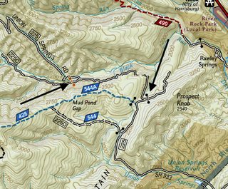
I'm using the Nat Geo layer and researching George Washington NF. I see the symbol for a gate but there's two different colors of them... Black/brown.. What's the difference?

Member III
I'm using the Nat Geo layer and researching George Washington NF. I see the symbol for a gate but there's two different colors of them... Black/brown.. What's the difference?
Not sure if there's a difference but I can say those are both closed gates. There's not much deviation off Union Springs that isn't private land or restricted forestry roads.
Influencer II
Influencer II
Here's another.. Black diamond with number in it. No in the legion that I see... Nat Geo again.
I'm thinking it's 'select paved' going by just the road color. Still wondering if 80 is a forest road? Kinda nice if it is!

I'm thinking it's 'select paved' going by just the road color. Still wondering if 80 is a forest road? Kinda nice if it is!

Enthusiast III
80 seems to be a paved state highway. I'm going to recommend that when you are looking in a National Forest to use the the USFS 2016 map and MVUM (USFS) layer. Nat Geo is good for finding stuff, but in Virginia especially you really need to use the MVUM layer to get the open/close dates. LotsHere's another.. Black diamond with number in it. No in the legion that I see... Nat Geo again.
I'm thinking it's 'select paved' going by just the road color. Still wondering if 80 is a forest road? Kinda nice if it is!
View attachment 204109
Offline Routing Added to Gaia GPS!
The latest version supports offline routing. When you download a map area just make sure the option to download offline route data is selected.
For your current map downloads go to the downloaded map, tap more, and then tap Download Offline Routing Data
This will be a nice feature if you want to modify where you are going and don't have cell coverage.
Android Auto is here! (There is a dedicated thread)

 blog.gaiagps.com
Gaia GPS on Android Auto: Put the Best Backcountry Maps on Your Dashboard - Gaia GPS
Access the entire Gaia GPS map catalog on your dashboard and navigate obscure backroads with Gaia GPS on Android Auto.

Expedition Master I
- 8,095
- First Name
- Vance
- Last Name
- Ely
- Member #
28800
- Ham/GMRS Callsign
- WRNX949 is my GMRS, haven't taken my test yet but working on the HAM
- Service Branch
- USAF BRAT
this is an awesome link. Great info THANK YOUAndroid Auto is here! (There is a dedicated thread)
Gaia GPS on Android Auto: Put the Best Backcountry Maps on Your Dashboard - Gaia GPS
Access the entire Gaia GPS map catalog on your dashboard and navigate obscure backroads with Gaia GPS on Android Auto.

Pioneer II
- 6,020
- First Name
- Dustin
- Last Name
- Helms
- Member #
24720
- Ham/GMRS Callsign
- KD2UNH
- Service Branch
- USAF

Explorer I
Gaia was recently acquired, so I’m guessing the new owners are recouping their investment.
maybe out in left field,but…
is Gaia usable for street navigation day to day address finding?

Trail Blazer II
It's not Google Maps, but the latest version will let you search for a street address and guide you to it. It also allows you to record the track.
Gaia was recently acquired, so I’m guessing the new owners are recouping their investment.
maybe out in left field,but…
is Gaia usable for street navigation day to day address finding?
Explorer I

Advocate III
- 5,584
- First Name
- Michael
- Last Name
- Rose
- Member #
20990
- Ham/GMRS Callsign
- W7FSB
- Service Branch
- US ARMY Retired
OB1 will have this feature soonThank you, my Magellan finally died. Be nice to have a single device
Explorer I
