Member III
- 2,268
- First Name
- Scott
- Last Name
- Viking
- Member #
17968
- Service Branch
- Air Force Veteran
Member III
17968


Advocate II
Anybody use this? It's pricey but looks like it might be a good option! They have other options that are more expensive with larger screens, better prices on Amazon!
Tread® 2
That something, a real early 21st Century thing, for the Overlander who has most everything I suspect, showing snowmobile trails!Anybody use this? It's pricey but looks like it might be a good option! They have other options that are more expensive with larger screens, better prices on Amazon!
Tread® 2



Off-Road Ranger I
0745
Agreed, I’m subscribed to Gaia. I’ll give it another try when we get back out west. So far- not impressed. We were in Grand Staircase and then up into the San Rafael Swell. Our Nat Geo maps were much more accurate than Gaia. We also Google earthed the area for even more detailed info. However, our best adventures and discovery of the best campsites has always been and remains to be, seat of the pants navigation and checking the paper maps once in a while.Gaia lost me with a severe price hike, lack of new features/polish, and the removal of my most-used map layer. In protest, I gave OnX a try. It's fine, I guess. Neither of them have ever worked like I wanted them to.
Avenza has the map layer I want, but has no web-based interface to build routes and add markers. I'm not doing all of that on a phone/tablet. I have too much data to move over. I need a keyboard, mouse, and a large screen to work from.
I'm looking forward to what Mapkind is able to offer. Mapkind GPS Developer Venture4wd/Chris has lived and breathed maps for years. I know he understands the sort of functionality we need most from a mapping app.


Influencer II
25039
Off-Road Ranger I
0745
15 years ago the kids insisted we get a PLB. So we did. I keep it registered and carry it with us when we are hiking. Just in case. Starlink has made almost all other long distance communication devices obsolete. Our kids gave us a Starlink mini as we began our full time travels. There is something to be said for being able to make or receive a phone call from friends or family when we are hours or days away from any cell phone service.Two caveats before I light this fuse. Yes, every electronic toy in your rig will eventually fail at the worst possible moment, so have a backup. And yes, not everybody wants to spend absurd amounts of money turning their truck into a rolling NASA experiment.
Still, Starlink may be the single most useful piece of off roading equipment I’ve bought in years. Constant connectivity changes the whole game. Gaia, OnX, Overland Bound, Google, whatever digital map poison you prefer, all of it keeps working out in the dead zones where cell service disappears and common sense usually goes with it. Even when you forgot to preload maps because you were too busy airing down tires and congratulating yourself on being “prepared.”
And the Starlink Mini feels strangely reasonable price wise once you compare it to the rest of the electronic bling people build into their rigs. HAM radios, Garmins, boosters, enough wiring to interrogate Soviet spies. Relative to that madness, the cost barely registers.
The real comfort comes later, deep in the middle of nowhere, when something mechanical starts coughing and grinding in the dark and you realize you can still call for help. That changes the mood considerably.



Enthusiast III

Advocate II
5615
Off-Road Ranger I
0745
Well, no, seat of the pants navigation is being quite the opposite of being blind. I was recently is a remote area without paper maps and without digital maps because of the heavy canopy. I broke camp and knew I wanted to be heading in a generally southwest direction so I made a right hand turn and followed my instinct. I knew it was important to follow along the ridge line. It was obvious to me that at each of three intersections I came to that I kept going straight, as I did not want to cross over the ridge or go down to the rushing creek below. I wanted to follow along either knowing that eventually the creek and or, the ridge, would bring me to a paved road. After about 3 hours I did come upon a paved country road, made a left, crossed the creek and finally regained service. Pulled up a digital map and found that I was just about where I wanted to be. As a young person I used to haul show livestock to various livestock shows all over Ohio and Pennsylvania. We had state maps back then, but not much in the way of details. I’d get to a town or small city and usually find the show barns, by the seat of my pants. My wife and I often put all the maps down, get to a fork in the road, and take it. That’s how we discovered beach camping on your wonderful Cape Freel.The apps are only useless and "fancy" if you don't know how to use them. I find them MUCH better than paper maps since I have actual satellite imagery on my Gaia app and can see the actual landscape, no paper map will give you that vantage point. Isn't seat of the pants "navigation" just driving blind? I never heard of that term before. I load the maps and views I want, and I am going it with a much more concise picture of where I am going before I leave to go anywhere.


Trail Blazer III
20527

Off-Road Ranger I
0745
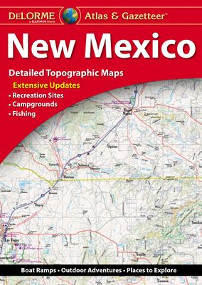
My feeling as well about paper maps, one can see the entire region and understand immediately our relevance in it. Yes, one can expand or contact on a screen, it as soon as you expand the area, the details are lost. Paper gives us the best of both worlds. Are those Delorme Gazetteer maps available on the shelf at outfitter stores?think of it as construction work....the hammer is the old paper map and the cordless nail gun is the electronic app. instead of choosing just the one, have BOTH.
I'm old school and love my paper maps...like the hammer, they are always available and very reliable and I'm very comfortable using them. my wife kicks butt with electronics and is very adept at using Google to find BLM land and dispersed camp sites along with everything else. she can find the nearest gas station when we are running on fumes. lots of great stuff that I cant get from a paper map. then there are times we don't have reception...well, a LOT of times without reception because we like being that remote. and times where the battery is dead and she lost the charger or whatever. the fancy nail gun/electronic app wont work and that is when the hammer comes in to save the day.
in addition to a road Atlas, I also buy the gazetteers that have extremely detailed information including topographical maps and trails you might not even find on the electronic apps. i'm 100% confident in my paper maps and the wife is very confident in her Google skills.
like I always tell my wife...i'm an "AND" person, not an "OR" person. I don't want either a paper map OR an electronic app...I want a paper map AND an electronic app
don't know how many of y'all know about the gazetteer, but it is a really good map to have if you are going deep into a specific area. I bought the new Mexico gazetteer specifically for our trip to the Gila and it was very much worth the $20 for all the good detailed info it had. I really like maps like this because I can sit at the campsite and see the entire area I'm interested in versus only seeing a little at a time on a phone screen. I just prefer to see more of an overall view that only paper maps can give.
come to think of it...I generally use my paper maps to plan the trip and my wife navigates and uses the phone app to assist and fine tune the trip as we go.
View attachment 301902
Trail Blazer III
20527
Well said, I am also an 'AND' person, especially cake AND ice cream ..... We always try to stop by the local land agency, forest service, BLM offices etc. and you can often get some great paper maps of the area from them often for free, along with some great tips of what to see or avoid, favorite hangouts for the animals etc.think of it as construction work....the hammer is the old paper map and the cordless nail gun is the electronic app. instead of choosing just the one, have BOTH.
I'm old school and love my paper maps...like the hammer, they are always available and very reliable and I'm very comfortable using them. my wife kicks butt with electronics and is very adept at using Google to find BLM land, dispersed camp sites, any sales at Dillards along with everything else. she can find the nearest gas station when we are running on fumes. lots of great stuff that I cant get from a paper map. then there are times we don't have reception...well, a LOT of times without reception because we like being that remote. and times where the battery is dead and she lost the charger or whatever. the fancy nail gun/electronic app wont work and that is when the hammer comes in to save the day.
in addition to a road Atlas, I also buy the gazetteers that have extremely detailed information including topographical maps and trails you might not even find on the electronic apps. i'm 100% confident in my paper maps and the wife is very confident in her Google skills.
like I always tell my wife...i'm an "AND" person, not an "OR" person. I don't want either a paper map OR an electronic app...I want a paper map AND an electronic app
don't know how many of y'all know about the gazetteer, but it is a really good map to have if you are going deep into a specific area. I bought the new Mexico gazetteer specifically for our trip to the Gila and it was very much worth the $20 for all the good detailed info it had. I really like maps like this because I can sit at the campsite and see the entire area I'm interested in versus only seeing a little at a time on a phone screen. I just prefer to see more of an overall view that only paper maps can give.
come to think of it...I generally use my paper maps to plan the trip and my wife navigates and uses the phone app to assist and fine tune the trip as we go.
as to the OP and his tagline "Those fancy mapping apps will not save you..." I do agree with that. if all we had was my wife and her phone and she dropped the phone in the creek...we're screwed as far as navigating. if all we had was my paper maps and I dropped it in the creek, I can still read it.
just sayin'
View attachment 301902
Enthusiast III
That's just being aware. I think all of us here do that instinctively. I know I do.Well, no, seat of the pants navigation is being quite the opposite of being blind. I was recently is a remote area without paper maps and without digital maps because of the heavy canopy. I broke camp and knew I wanted to be heading in a generally southwest direction so I made a right hand turn and followed my instinct. I knew it was important to follow along the ridge line. It was obvious to me that at each of three intersections I came to that I kept going straight, as I did not want to cross over the ridge or go down to the rushing creek below. I wanted to follow along either knowing that eventually the creek and or, the ridge, would bring me to a paved road. After about 3 hours I did come upon a paved country road, made a left, crossed the creek and finally regained service. Pulled up a digital map and found that I was just about where I wanted to be. As a young person I used to haul show livestock to various livestock shows all over Ohio and Pennsylvania. We had state maps back then, but not much in the way of details. I’d get to a town or small city and usually find the show barns, by the seat of my pants. My wife and I often put all the maps down, get to a fork in the road, and take it. That’s how we discovered beach camping on your wonderful Cape Freel.
Enthusiast III