@M Rose , seems like we could all benefit from any tutorial vids from you. This, or probably a wide range of subjects. Do you have some up on youtube or something?This subject matter is whole school year of information... I taught Land Navigation in the Army. (Referenced in the manuals above.). I held (if not hold) the fastest Land Nav time (and score) at the Fort Bliss WLC Land Nav Course. 39/40 points in under an hour... I ran through the corse and the compass stayed in my pocket most of the time.
To get good at it you have to practice. You need a good lensetatic compass... and a detailed topographic map of the area you want to practice in.
Orienteering by hand?
- Thread starter kilby
- Start date

Advocate III
- 5,584
- First Name
- Michael
- Last Name
- Rose
- Member #
-
20990
- Ham/GMRS Callsign
- W7FSB
- Service Branch
- US ARMY Retired
I have never done a YouTube Videos. I have given classes several times in the past. Let me dig through some of my old materials and see if I can put something together. Maybe a Zoom meeting or something for a couple hours a night/week to get through the materials. Most of the learning process can be done in a classroom setting.@M Rose , seems like we could all benefit from any tutorial vids from you. This, or probably a wide range of subjects. Do you have some up on youtube or something?

Enthusiast III
On this all else depends. This declination adjustment changes a degree every 5 years or so.
See. This is the stuff I wanted to know! DECLINATION. I would have gone out there and ended up in North Nevada trying to get to Idaho. Y'all saved me from living Into The Wild 2!
I want to agree with you on this. I have at least 2 G shock watches, one is an old GP100 and the new one is one of their new stainless steel line.Rad! I just ordered a Suunto, but kind of like bikes and watches I can envision an N+1 scenario with these tools.
Also, I have two old Mongoose mountain bikes. Kept in good condition they are as good as anything made today. Heavier, but smaller and more rugged perhaps.
While I still have my old Silva Ranger Type 15, I also have a couple smaller cheapo depot ones kicking around. I should probably upgrade the cheap ones and leave one in each pack
See. This is the stuff I wanted to know! DECLINATION. I would have gone out there and ended up in North Nevada trying to get to Idaho. Y'all saved me from living Into The Wild 2!
Get some good, NEW topo maps. They will state the declination right on them as part of the legend. They should also have TWO north arrows, one for magnetic one for true. That way you can lay the compass down, line it all up, and turn the screw until the needle points to the true arrow. The you can proceed with the practice
It's fun. I also remember my father telling us some of the (obvious?) tricks, like if you are lost, follow a river, they always lead to civilization at some point, or be watching for power lines (is you are not TOO far out) and follow those, little tips on how to get to civilization if you are lost. Having nothing to do with actual Orienteering, but still helpful in the woods
Boostpowered
Rank VI

Member III
When I was your kids age I Would go out in the woods to try to get lost just for fun. I learned early that I have an internal compass no stars or sun to follow I somehow just knew which way is n,s,e,w and always found home. To this day I still have it though not quite as strong as it was when I was young.
I'd suggest teaching him about creeks and rivers and what direction they flow depending on where you are and how a river usually will lead to civilization. Also to navigate using the sun during the day and moon and stars at night. There is even the ole moss only grows on the north side of trees( true in some areas and not in others so not as accurate but good enough if you know what your doing)
Even teach how him to make a compass using a needle, a leaf and water so no matter what he will have the tools he needs if compass isn't available.

Advocate III
- 5,584
- First Name
- Michael
- Last Name
- Rose
- Member #
-
20990
- Ham/GMRS Callsign
- W7FSB
- Service Branch
- US ARMY Retired
I’m a lot like you, I have never been disoriented... even in different hemispheres. Remember the story of Hansel and Gretel being lead through the woods? That story always confused me because I always knew the way home.When I was your kids age I Would go out in the woods to try to get lost just for fun. I learned early that I have an internal compass no stars or sun to follow I somehow just knew which way is n,s,e,w and always found home. To this day I still have it though not quite as strong as it was when I was young.
I'd suggest teaching him about creeks and rivers and what direction they flow depending on where you are and how a river usually will lead to civilization. Also to navigate using the sun during the day and moon and stars at night. There is even the ole moss only grows on the north side of trees( true in some areas and not in others so not as accurate but good enough if you know what your doing)
Even teach how him to make a compass using a needle, a leaf and water so no matter what he will have the tools he needs if compass isn't available.
As a kid my dad would blind fold us and take us out to the mountains and walk us around in circles for hours before removing the blindfold. He then would have us sit on the log and asks us where the car was, where the house was, even ask what direction a distant person lived. My brother and sister very rarely could get the answers correct without the use of a compass... me on the other hand never missed a beat. I just have a good sense of direction.
As mentioned by others... water always flows to civilization... always... if the creek bed runs dry, keep fallowing it down hill, either another wash will run in/out, or it will join up to another larger body of water... eventually all water finds its way to the ocean. Between here and there, you will have to cross a road, power line, fence, or something man made. I don’t recommend fallowing fences though... fences can mess with your mind if you are turned around.... my dad has a few fence stories while hunting in blizzards... a fence almost killed him once. He was turned around, he slipped and fell breaking his compass, and not only was it white out conditions, but the fog was very heavy as well. He was hunting in an area where there was only one fence. He had parked the rig with the fence to his north and walked south. After several hours he hit a fence. No way this could be the fence next to his rig, he decided to do a 180 degree turn and walk back the way he came... about an hour later he crossed another hunters set of tracks intersecting his own. He decides to fallow the other tracks thinking this person knows where they are going. Well those tracks dead end at another fence. This time he decides to cross the fence. A few hundred yards after the fence he finally meets up with another hunter who points him to the road, the hunter also said as my dad was leaving.... btw, your rig is 20 yards that way, pointing the opposite direction of the way my dad was going to walk back to the road.
sure enough, 20 yards up the hill was his scout...50 yards from where he stopped the first time to cross the fence... and 50 yards from where he did cross the fence.
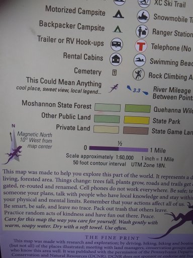
You will want to find this info on your map. The variation of magnetic north is shown in the bottom left corner here.
When orienteering it is also very important to make sure you are in the exact starting spot.
Using triangulation to find your location on the map is another thing to learn. If you can see 2 objects from the map you will get close
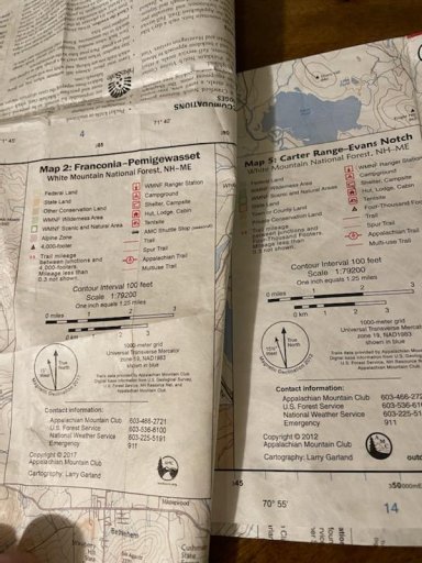
Here's another example. Both are AMC Trail Maps of the White Mountains. But they are maps of different regions, right next to each other, and the cartography was 5 years apart.
Map 5 is copyright 2012, easternmost section of the White Mountains - the Carter Range. 15 and a half degrees of west declination
Map 2 is copyright 2017, more central, Franconia Notch and Pemi Wilderness. 15 degrees even of west declination.
Is it the 5 years difference, of is it just that the Pemi Wilderness and Franconia Notch are just that much further west than the Carter Range?
We could figure that out, but the point is to batch for that stuff and adjust your compass accordingly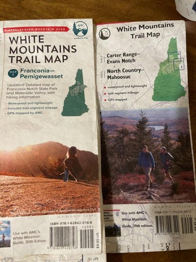


rgallant
Rank III

Advocate I
- 808
- First Name
- Richard
- Last Name
- Gallant
- Ham/GMRS Callsign
- VE7REJ
- Service Branch
- RCAC (Reserve) 75-00
As noted a good compass, good maps of an appropriate scale. On foot and vehicle are pretty different experiences.
As I predate military use of GPS everything we did was map and compass, once you get the hang of it it is simple enough, although many people struggle with tracking distance and switching form vehicle to foot.
A few points that may seem obvious:
As I predate military use of GPS everything we did was map and compass, once you get the hang of it it is simple enough, although many people struggle with tracking distance and switching form vehicle to foot.
A few points that may seem obvious:
- Be aware when reading up, some terms are different in various countries example up here in Canada we bearing and back bearing, the US military used to use azimuth same thing different word
- Map reading is pretty critical being able to translate what you see on the map to the ground around you, understanding contour lines and other markings
- Learn to mark known points - more critical when covering distance in a vehicle. But for example if you hit a small bridge over a creek and know where it on the map make a mark on your map. It represents a place you can use to figure out where you went wrong if you get turned around.
- Try to aim for little targets on route, so if there are markers you can hit between the two points use them
- Knowing your stride is great but have some alternate methods of judging distance
- Finally night, or any weather that restricts you view is very different from day time, your sense of time gets messed up having a good watch really helps

Member III
I learned at a young age to navigate in cub scouts. Later when I was in an ANGLICO company I learned the fine points of precise navigation and Targeting. Later in life I taught weekend camping / orienteering classes to green horns and it was always fun to see them get all turned around at the beginning and after the class be able to navigate correctly. I also taught how to navigate with no compass by using stars or a standard wrist watch or sticks, stones and other things in nature. There are ways to tell time without a watch and ways to determine when the sun will set or knowing these things you can also determine what direction is North.

Member III
Finding the North star... First find either the little or big dipper. Keep in mind both dippers rotate around the North star and in some areas and certain times of the year they can be under the horizon. The up side is normally one of them will be above the horizon.
The North star will be at the end of the handle on the little dipper...
If you find the big dipper draw a line through the two stars opposite the handle one on bottom one on the top they are called Dubhe and Merak. Put your middle finger on one star and the index finger on the other. Extend that span 5 times and you will be at the North star.
After locating the North star draw a line from the star to the horizon and that will be North...
Now if you draw a line from Dubhe through Marak to the North star you can consider this the hour hand. Keep in mind this may not be 12 o'clock but, it will be in the same location 23 hours and 56 minutes later. How can we use this information... Well for example if it is lined up with 12 o'clock today in 23 hours and 56 minutes it will be back in the same spot... But remember it is 4 minutes fast each day so next month it will not be in the same alignment and some night you may not see it...
Just did an impromptu basic compass & map tutorial for my niece and nephew. They love to camp and kayak and fish, but have always done that with thier parents. Thier dad and I have been friends since '85 and went to a local EMS store together to buy our Silva Type 15's probably around 1988 + -See. This is the stuff I wanted to know! DECLINATION. I would have gone out there and ended up in North Nevada trying to get to Idaho. Y'all saved me from living Into The Wild 2!
Anyway, they caught on quick, enjoyed the lesson.
Trail Blazer III
Land Navigation is definitely a skill that seems to be rare. It is fun and can be challenging at times with all the different considerations but is always going to be beneficial especially if your GPS runs out of juice or breaks. I find the most difficult aspect is finding maps. I am only knowledgeable in the MGRS system so lat/long is foreign to me.
It's still a horizontal/ vertical translation, but I imagine maps are tough to come byLand Navigation is definitely a skill that seems to be rare. It is fun and can be challenging at times with all the different considerations but is always going to be beneficial especially if your GPS runs out of juice or breaks. I find the most difficult aspect is finding maps. I am only knowledgeable in the MGRS system so lat/long is foreign to me.

Contributor III
The biggest thing with orienteering is not the compass but your map. Learning how to orient your map to the terrain in your location. How to properly read your map and the map key. Your convenience store maps won't work. You need the topographic maps. The Gazetteer map books for your state are some of the best ones to use. Orienteering is real big in Europe and specifically Germany. No compass, strictly map.
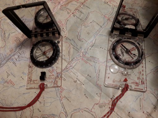
Within the last week or so, I went to Kittery Trading Post and picked up a Suunto MC-2 USGS, a Brunron TruArc 5 and a Brunton TruArc 15 (and a couple Suunto MD Leaders, but those are for the niece and nephew). These are in addition to my very old - but still very functional - Silva Ranger Type 15.
The Bruntons (US made) have an odd new way of adjusting declination without any need for a tool, and both come with a global needle. The Suunto (made in Finland) uses a set screw to adjust declination but it is on the back side of the rotating bezel. While the Suunto offers a global needle, I did not get that option.
This Suunto is closest in size, feel, and functionality to my old Silva. Silva still makes compasses, but they are now "designed in Sweden" and made in China. I am not sure the quality of the new Silvas. With 4 compasses now, I would be hard pressed to justify one more, but I might, just to test the Chonese made Silvas.
While I havent really experienced any issues with any if these new ones, parts of each of them seem less quality than the old Silva, and parts of each seem better, if that makes sense. But none seems quite as good overall. It might just be that I've had the same compass for over 30 years.
Here's the old Silva on the left with the new Suunto on the right


Member III
In Germany and many other places I have lived no compass is not a big thing... But some places like the desert, deep woods like Oregon, Washington or flat lands like Florida it can become a problem. But, like I mentioned before a simple watch or knowing what time it is can be used to determine a heading or even knowing when the sunrises or sunsets can also be used.The biggest thing with orienteering is not the compass but your map. Learning how to orient your map to the terrain in your location. How to properly read your map and the map key. Your convenience store maps won't work. You need the topographic maps. The Gazetteer map books for your state are some of the best ones to use. Orienteering is real big in Europe and specifically Germany. No compass, strictly map.
Bushcraft Padawan has a very good series on land nav basics. I watch it whenever I want a refresher.
Bushcraft Padawan
Bushcraft Padawan

