
Computer has been dead so just saw this, thank you for linking that.Here's 50% off the 5 year plan if you decide to get Gaia. Lifestyle Overland Discount | Gaia GPS
Oklahoma Adventure Trail
- Thread starter Oventure
- Start date
You are using an out of date browser. It may not display this or other websites correctly.
You should upgrade or use an alternative browser.
You should upgrade or use an alternative browser.

Traveler III
- 1,815
- First Name
- Ryan
- Last Name
- Horner
- Member #
16636
- Service Branch
- USAF
Anyone done the south west part from Sayre to Mangum, Mangum to Mt Scott and Mt Scott to Sulphur Springs? Gonna be doing it this weekend with the wifey.
Last edited:

Enthusiast I
- 404
- First Name
- Ryan
- Last Name
- Swank
- Member #
0308
well how did it go?Anyone done the south west part from Sayre to Mangum, Mangum to Mt Scott and Mt Scott to Sulphur Springs? Gonna be doing it this weekend with the wifey.

Some guys from the Toyota group and I did the SouthWest portion of this last weekend. It was dusty but fun, with one nighttime river crossing... about 380 miles in one day. If you're doing any other portions in the next few weeks, let me know. I'd like to do another section this monthBump for anyone that's done this in the past year. Thinking about doing part of the NE section this weekend.

Member III
Might check this thread out.Bump for anyone that's done this in the past year. Thinking about doing part of the NE section this weekend.
OAT trips
I decided to get some real "social distancing" today by doing a day trip on the OAT. Started in Colbert and ended in Hugo. Came across this cool bridge that said it was made in 1905 All the roads were passable but since it had been raining for the last week, there were a few places where it...
Member III
Some guys from the Toyota group and I did the SouthWest portion of this last weekend. It was dusty but fun, with one nighttime river crossing... about 380 miles in one day. If you're doing any other portions in the next few weeks, let me know. I'd like to do another section this month
Might check this thread out.
OAT trips
I decided to get some real "social distancing" today by doing a day trip on the OAT. Started in Colbert and ended in Hugo. Came across this cool bridge that said it was made in 1905 All the roads were passable but since it had been raining for the last week, there were a few places where it...www.overlandbound.com
Thanks guys. I appreciate it. If you guys are looking for a good drive, I did a day trip around Tahlequah last weekend and it was beautiful. There's miles of good driving east of the Illinois river. Ton of little streams and small water crossings. A couple hiking trails in the Nature Preserve as well.I know one OB'er thats doing the section east of 35 and plans to do a trip report when he gets back. He told me last night that the river crossing in the altus wildlife area is a no go. About 4' plus big drop off going in.
Yes that's true, they even have the road completely blocked, you can't get to it. the updated GPX has a drive-around that oneI know one OB'er thats doing the section west of 35 and plans to do a trip report when he gets back. He told me last night that the river crossing in the altus wildlife area is a no go. About 4' plus big drop off going in.
Sorry if this is a stupid question, but where would I find the updated version?Yes that's true, they even have the road completely blocked, you can't get to it. the updated GPX has a drive-around that one
Member III
Here

 advrider.com
Making of the "Oklahoma Adventure Trail"
Oklahoma Adventure Trail This thread will be used for us to build the "Oklahoma Adventure Trail" If anyone would like to help with any section either...
Thanks for sharing! Any advice on the southwestern section around Wichita Mountains National Refuge? We're in a '97 Lexus LX. We're very new to overlanding and I feel a little apprehensive about doing an overnight trip, but we're dying to get away during all of this "quarantine" business. It's the perfect excuse to embark on our second official overland adventure.Yes that's true, they even have the road completely blocked, you can't get to it. the updated GPX has a drive-around that one
Also, is it pretty easy to find a spot to camp overnight around there without getting gruff from law officials during this?
Member III
You might also check with @ryanorr280 He just did that section.Thanks for sharing! Any advice on the southwestern section around Wichita Mountains National Refuge? We're in a '97 Lexus LX. We're very new to overlanding and I feel a little apprehensive about doing an overnight trip, but we're dying to get away during all of this "quarantine" business. It's the perfect excuse to embark on our second official overland adventure.
Also, is it pretty easy to find a spot to camp overnight around there without getting gruff from law officials during this?
Thanks so much for the tip! I’ll reach out to him.You might also check with @ryanorr280 He just did that section.
Enthusiast I
So I was manually inputting the route into Gaia and after an hour and a half the app crashed and I lost everything  This is my first time using the app so I'm making this harder than it should be, I hope .Can anyone point me in the right direction to just download the route straight to the app so I can save it?
This is my first time using the app so I'm making this harder than it should be, I hope .Can anyone point me in the right direction to just download the route straight to the app so I can save it?
Member III
What are you trying to download it to? When I tried to download it to my ipad 1st gen it wouldnt work. But it uploaded in a matter of seconds to my ipad 4. I down loaded straight from the advrider website.So I was manually inputting the route into Gaia and after an hour and a half the app crashed and I lost everything
Enthusiast I
Bro, I didnt even download it. I was painstakingly doing it by handWhat are you trying to download it to? When I tried to download it to my ipad 1st gen it wouldnt work. But it uploaded in a matter of seconds to my ipad 4. I down loaded straight from the advrider website.
I'll try to download it on my new iphone and I'll report back. Thanks for the quick response.Edit:
You're a hero and you didnt even have to break a sweat! Got it downloaded in Gaia

Enthusiast II
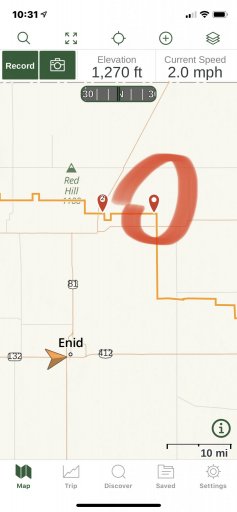
FYI, I drove part of the Great Salt Plains to Perry section yesterday. There is a spot that I was not going to attempt by myself ,marked on the map. Not knowing how else to update the map I added a way point with pics and a note.
Attachments
Member III
- 2,827
- First Name
- Joshua
- Last Name
- Downs
- Member #
20468
- Ham/GMRS Callsign
- KK6RBI / WQYH678
- Service Branch
- USMC 03-16, FIRE/EMS
I can't remeber if they have the "Clayton Trail" on there or not anymore. It's been bulldozed at the Clayton trail and K Trail intersection by the company putting in the wind farm in the area. They shoved a huge tangle of trees down onto the trail making it impassible. Supposedly the road has been "closed" for a long time but there's no signage or anything (the last time I was out there) to indicate that.
We made our first small trek from Davis to Wichita Moutains WR. We ran in to one road that was closed off, but easily got around it. It was marked on the map as “closed for hunting,” so we weren’t totally thrown off by it. We compiled a video of our first overland trip. It was an awesome start!
