
Sorry I missed it, I had a last minute work emergency and needed to be at a jobsite first thing this morning. To top it off, everyone was late by over an hour.
Los Angeles Westside Meetup?
- Thread starter Barclay
- Start date
You are using an out of date browser. It may not display this or other websites correctly.
You should upgrade or use an alternative browser.
You should upgrade or use an alternative browser.


Influencer I

Hey guys. Celebrating my birthday weekend exploring Joshua Tree and the surrounding areas. Looking to check out Berdoo Canyon, Painted Canyon Drive, Old Dale Road, and end my weekend taking Pioneer town towards Big Bear on my way home to Orange County CA on Sunday. This will be my first major weekend trip in prep for Zion and Sedona this summer. Leaving at the crack of dawn next Friday and spending my first night in Agua Caliente just because I have never been. It’s 39 miles from the park. I'll start exploring friday morning. Any suggestions or advice on where to stay or eat? And what else is good to check out around that area? Anyone in the area the weekend of 3/2 - 3/4?
Sent from my iPad using Tapatalk
Sent from my iPad using Tapatalk
Influencer I
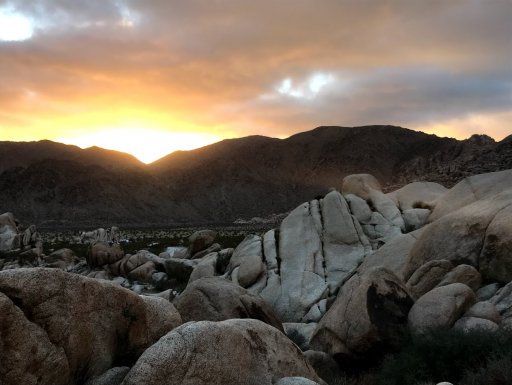
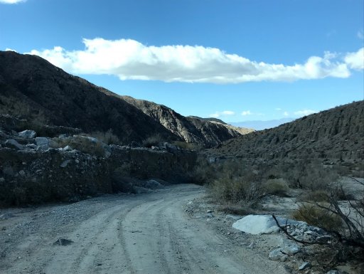
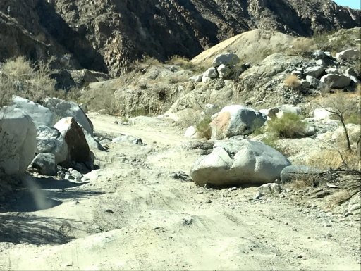
I just did Berdoo Canyon last Monday (North to South), it's a pretty easy except for a couple technical sections. What are you driving? If your car is the one in your avatar pic, the one place I'd worry about is a little S-curve section that has some ~12" rocks without a lot of room to maneuver (of course, they always appear bigger than they really are, so perhaps I'm exaggerating). For reference, I'm in a JKU w/ 4" lift and 35"s, and cleared it fine, but I wasn't sure I would. That section is listed as "rockgarden 2" in the GPX file from https://www.trailsoffroad.com/trails/1128-berdoo-canyon. Also I think it's the part starting at 2:50 on the video, but looks a little different from my memory, so there could have been some additional rocks that fell in. My GPX file and a couple photos attached: indiancove was where we camped, wash is just a cool section where you're driving next to this erosion wall, and waterfall is (I think) the part listed as "waterfall" at the trailsoffroad link. I forgot to take a pic of the S-curve section.
In any case, it's really beautiful but cold out there right now (it snowed!), and take note that the S end is all shooters. AFAIK, there's not a lot of off-roading in Joshua Tree proper, but I'd be interested in Old Dale and Brooklyn Mine as well. For camping, the best spots I've seen are either the official drive-in spots or where you park and hike in for backcountry camping. The North Joshua Tree BLM is pretty crappy; the spots I saw had lots of trash and were not near all the cool rocks to climb on. If you're heading up to Pioneer Town, there's a zillion trails all over the Johnson Valley. Another option would be to take Rattlesnake Canyon up into Big Bear, which would be a more southern route. It'll probably also be super-cold -- I think it's supposed to be snowing in Big Bear this and next weekend. Good luck and have fun!
In any case, it's really beautiful but cold out there right now (it snowed!), and take note that the S end is all shooters. AFAIK, there's not a lot of off-roading in Joshua Tree proper, but I'd be interested in Old Dale and Brooklyn Mine as well. For camping, the best spots I've seen are either the official drive-in spots or where you park and hike in for backcountry camping. The North Joshua Tree BLM is pretty crappy; the spots I saw had lots of trash and were not near all the cool rocks to climb on. If you're heading up to Pioneer Town, there's a zillion trails all over the Johnson Valley. Another option would be to take Rattlesnake Canyon up into Big Bear, which would be a more southern route. It'll probably also be super-cold -- I think it's supposed to be snowing in Big Bear this and next weekend. Good luck and have fun!
Attachments
Thanks for the heads up and advice Barclay. Installing 3" Rough & Country suspension lift before my trip. Still on 31s though. Hopefully 33s by next month.. So Berdoo Canyon Road and Berdoo Canyon Trail are not the same right? I hope the weather wont be too bad. Do you think Ill need chains or tracks? My truck is 4x4.
Sent from my SM-N950U using Tapatalk
Sent from my SM-N950U using Tapatalk
Im using Gaia/Alltrails/Google Maps offline on my iPad Air2 for navigation BTW.Thanks for the heads up and advice Barclay. Installing 3" Rough & Country suspension lift before my trip. Still on 31s though. Hopefully 33s by next month.. So Berdoo Canyon Road and Berdoo Canyon Trail are not the same right? I hope the weather wont be too bad. Do you think Ill need chains or tracks? My truck is 4x4.
Sent from my SM-N950U using Tapatalk
Sent from my SM-N950U using Tapatalk
Influencer I
I find Gaia best for offroading, even though it's UI is kind of clunky, and Alltrails better for hiking. Google Maps will actually route you through some surprisingly difficult places, which surprised me the first time it happened.
I'm not sure if there's a difference between Berdoo Canyon Road and Berdoo Canyon Trail; they come up as the same thing for me on my searches.
I'm not sure if there's a difference between Berdoo Canyon Road and Berdoo Canyon Trail; they come up as the same thing for me on my searches.
Influencer I
I find Gaia best for offroading, even though it's UI is kind of clunky, and Alltrails better for hiking. Google Maps will actually route you through some surprisingly difficult places, which surprised me the first time it happened.
I'm not sure if there's a difference between Berdoo Canyon Road and Berdoo Canyon Trail; they come up as the same thing for me on my searches.
Just realized I didn't answer a couple questions: I don't think you'll need chains unless you end up in high elevation big Bear (CHP might require it if the snow or ice collects) and sand ladders are always a good idea but probably not necessary for Joshua tree. Nothing too sandy there that I hit.
Sent from my iPhone using OB Talk
I agree with you on Gaia... Actually Alltrails showcases hiking trails but of you search for Off Road trails it offers it as well with a variety of maps and more. I have the Alltrails pro. It records your run with altitude levels and time.


Sent from my SM-N950U using Tapatalk
Sent from my SM-N950U using Tapatalk
Influencer I
I agree with you on Gaia... Actually Alltrails showcases hiking trails but of you search for Off Road trails it offers it as well with a variety of maps and more. I have the Alltrails pro. It records your run with altitude levels and time.
Sent from my SM-N950U using Tapatalk
You can record with Gaia as well, up to you which you use. Note that off-road ratings on alltrails is super inconsistent in my experience.
Sent from my iPhone using OB Talk

Advocate II
Just saw this thread. Glad you guys got together.
Don't get hung up on attendance numbers. The fact that you got together is cool enough. I've been to the OC, Simi & IE meets/trail runs. Even did a tour of the Toyota Museum with @VCeXpedition. Sometimes there were 6 people, others there were 60. But there were always smiles and plans made for future fun.
I'm always trying to convince new areas to start these meets, they'll catch on. Just plan in advance, and you'll get more people to come. If I wasn't working weekends in Feb, I'd of been there.
I'll be going out on the Bradshaw Trail run in 2wks with @FrankRoams and a bunch of others. Anyone here RSVP'd to that? I think it's full at 15 vehicles.
