Listing "Submit Your Overland Bound Routes" into regions/areas.

  • HTML tutorial

Who thinks this is either helpful or the current method is sufficient?


  • Total voters
    13

Kyle & Kari Frink

Rank VI
Launch Member

Pathfinder II

4,387
San Diego, California
Member #

6376

So I fully understand that you can search for just about anything on here by searching tags that are annotated by the user who submitted them. Now just like anyone we sometimes forget things like i.e. (tagging where the route is. Also I understand that most members will post the name of the route or sometimes the location in the title [but if your not from the area, you have no idea where that is], and thirdly if the member also posted the GPS location you could find it that way.) But what I am suggesting is that when the member goes to post a new thread of their overland bound route that a drop down menu of sorts is located for the user to go and select 1. the region and 2. a general location such as i.e. ( Southern California/ Northern California and such) along with that in this thread instead of it showing the most recently posted threads in order it would display them by region broken up into "areas" to make it more user friendly for someone to go find a route they are specifically looking for or just a new place to explore in the area they live. Maybe to take it one step further would be maybe that somehow these routes could be linked to a "Trail" marker on the map lol I don't know how difficult that would be to make happen but at a minimum I think it would be super helpful to have a dropdown menu when submitting routes so that a member could access what they want more readily. Just looking to help!
@Michael
 

Crossoverlander

Rank I
Launch Member

Contributor I

233
Indianapolis, IN
First Name
Scott
Last Name
Manners
Member #

19457

I think a map in the app or on the website would be super helpful that had approved gpx routes on the map. Something similar to the REI MTB Project app or AllTrails, you can literally zoom around the map and it has all the mountain bike routes' lines on the map, with a downloadable gpx for it. Just something that could help us find it visually rather than searching by name. Zoom in and around a map in your area and see all the trails people have done or routes would be amazing. you could click the line of the route and all its info pops up, such as length, trail terrain, difficulty etc...It doesn't have to be a working GPS/location-type app that tracks current location, but just a pre-planning type of thing that stores all the gpx linework and routes to plan your next trip!
 

Jim SoG

Forums Manager
Staff member
Moderator
Member
Investor

Educator I

10,890
Reno, NV, USA
First Name
Jim
Last Name
Bro
Member #

12989

Service Branch
USAF DAV
I think a map in the app or on the website would be super helpful that had approved gpx routes on the map. Something similar to the REI MTB Project app or AllTrails, you can literally zoom around the map and it has all the mountain bike routes' lines on the map, with a downloadable gpx for it. Just something that could help us find it visually rather than searching by name. Zoom in and around a map in your area and see all the trails people have done or routes would be amazing. you could click the line of the route and all its info pops up, such as length, trail terrain, difficulty etc...It doesn't have to be a working GPS/location-type app that tracks current location, but just a pre-planning type of thing that stores all the gpx linework and routes to plan your next trip!

We have a map and as people add the trails and such it gets more populated. Maybe a way to auto link it not sure, will ask.

jim
 

Jim SoG

Forums Manager
Staff member
Moderator
Member
Investor

Educator I

10,890
Reno, NV, USA
First Name
Jim
Last Name
Bro
Member #

12989

Service Branch
USAF DAV
So I fully understand that you can search for just about anything on here by searching tags that are annotated by the user who submitted them. Now just like anyone we sometimes forget things like i.e. (tagging where the route is. Also I understand that most members will post the name of the route or sometimes the location in the title [but if your not from the area, you have no idea where that is], and thirdly if the member also posted the GPS location you could find it that way.) But what I am suggesting is that when the member goes to post a new thread of their overland bound route that a drop down menu of sorts is located for the user to go and select 1. the region and 2. a general location such as i.e. ( Southern California/ Northern California and such) along with that in this thread instead of it showing the most recently posted threads in order it would display them by region broken up into "areas" to make it more user friendly for someone to go find a route they are specifically looking for or just a new place to explore in the area they live. Maybe to take it one step further would be maybe that somehow these routes could be linked to a "Trail" marker on the map lol I don't know how difficult that would be to make happen but at a minimum I think it would be super helpful to have a dropdown menu when submitting routes so that a member could access what they want more readily. Just looking to help!
@Michael
In the "Downloadable Routes" forum there is a prefix for selecting what region the route is in and almost all are designated, I requested a "Filter" element for selecting regions, so you could filter out everything but say the "West"........

Jim
 
Last edited:

Crossoverlander

Rank I
Launch Member

Contributor I

233
Indianapolis, IN
First Name
Scott
Last Name
Manners
Member #

19457

We have a map and as people add the trails and such it gets more populated. Maybe a way to auto link it not sure, will ask.

jim
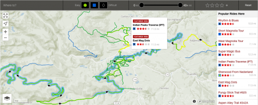
I know it shows starting points of trails. I think it would visually be super awesome if the entire gpx line populated the map, that way when pre-planning a trip you can just scroll around the map and see the physical route. something like REI's MTB Project app like this picture. for easy navigation in finding routes in your area, and click the trail line route to see all its info (difficulty, length etc...)1_dswMMap3GdWEmuEPBsVESw.png
 

RJCanyon

Rank V
Member

Member III

2,766
California, USA
First Name
Bobby
Last Name
Horne
Member #

19131

I know it shows starting points of trails. I think it would visually be super awesome if the entire gpx line populated the map, that way when pre-planning a trip you can just scroll around the map and see the physical route. something like REI's MTB Project app like this picture. for easy navigation in finding routes in your area, and click the trail line route to see all its info (difficulty, length etc...)View attachment 110292
this would be a huge help if they can implement this into the app
 

Crossoverlander

Rank I
Launch Member

Contributor I

233
Indianapolis, IN
First Name
Scott
Last Name
Manners
Member #

19457

this would be a huge help if they can implement this into the app
I don't even think it would be necessary to have GPS tracking/location capabilities within the map or app, save that for when you click on the route and actually download the gpx file onto a device. This could just be helpful as linework on the map to see what is around when pre-planning a trip, then clicking on the line of the route, it gives you its info and the gpx download button (terrain, difficulty <extreme-rock crawling...-...easy awd crossover gravel> , length, time to complete, and a short description etc) Would be amazing to have a huge compilation of routes people have done plastered on the map just for reference.
 
  • Like
Reactions: RJCanyon

MegaBug

Rank VII
Launch Member

Influencer II

6,414
Colwood, BC, Canada
First Name
Matt
Last Name
Lester
Member #

20270

Ah yes... a picture's worth a thousand words. This would be super useful in finding new route ideas and pre-planning. I agree it could be a simple line representation of the route with a link to the gory details.