Dispersed Camping in Missouri

  • HTML tutorial

UploadAdventure

Rank IV
Launch Member

Enthusiast III

1,277
Dixon, MO, USA
First Name
Rich
Last Name
Monsalvo
Member #

21122

A couple more options are the baltimore bend area in Missouri, dispersed camping is allowed, but fires are restricted to established areas only.
How big if the Baltimore bend conversation area? Can you camp on the other side of the railroad tracks?
 
  • Like
Reactions: Broke

Broke

Rank 0
Launch Member

Contributor III

116
Blue Springs, MO, USA
First Name
Adam
Last Name
G
The area is 1,202 acres, limited road access. If memory serves you can not camp between the tracks and the river, but, you can camp next to the river, if you are floating in.


The area between the tracks and the river is part of the big muddy national wildlife refuge. I am trying to find the regulations on what you can do there, and not having much luck.
 
  • Like
Reactions: UploadAdventure

UploadAdventure

Rank IV
Launch Member

Enthusiast III

1,277
Dixon, MO, USA
First Name
Rich
Last Name
Monsalvo
Member #

21122

The area is 1,202 acres, limited road access. If memory serves you can not camp between the tracks and the river, but, you can camp next to the river, if you are floating in.


The area between the tracks and the river is part of the big muddy national wildlife refuge. I am trying to find the regulations on what you can do there, and not having much luck.
That website is awesome. I’m going to have to do some more exploring of that. I wonder if there are any good little trails to drive into to camp.

Looks like a good spot for sure.
 
  • Like
Reactions: Broke

Atc210

Rank IV
Member

Enthusiast III

1,253
Columbia, MO, USA
First Name
Adam
Last Name
D
Member #

25836

As I read through these threads, I find myself wondering if my Gaia GPS is broken. Are these trails on Gaia, if not how can they get added for a one stop shop? I am new to Gaia and MO trail systems so apologize in advance for my ignorance.
 
  • Like
Reactions: Broke

Broke

Rank 0
Launch Member

Contributor III

116
Blue Springs, MO, USA
First Name
Adam
Last Name
G
Gaia is not broken per se, it just doesn't reflect changes that have been made the the motor vehicle access areas. It shows trails and roads no matter the status although I did notice this past weekend that if you pay attention to the legend it does show the end of the official trail. But there is no signage or apparent change to the terrain as a result so it is very easy to end up in an area that is closed to motor vehicles.
At one point this weekend I realized that even though I was on a maintained (roughly) road, adjacent to private property, I was not on a trail or road that was even on Gaia. Was it a landowners road used to maintain fence rows? Old logging access road? I have no idea, and as soon as I realized I was out of bounds I found a safe place to turn around and went back the way I came. It can be very confusing. The only moderately accurate way I have found is to use Avenca with the MVUM as a pdf as the map, but that was not incredibly accurate in its ability to plot your location. I think my next step will be to run Gaia on my phone and Avenca on a tablet or other GPS enabled device. That will require buying a pan-a-vise mount or fabricating a dash bar to use RAM mounts on. At that point I will be looking at the screens more than the scenery...

The previous trip we made to MTNF some locals gave us a paper map of the MVUM and basically said in their interactions with the rangers your attitude about where you are, has a direct impact on how that interaction will go. My goal is to avoid being where I am not supposed to be. Having said that i pack out more than i bring in, don't tear up the roads, and make a strong effort to comply with the restrictions, correcting myself whenever I realize I am out of bounds. Not sure what else can be done, but I am working on improving my navigational systems to avoid any issues.
 
  • Like
Reactions: UploadAdventure

UploadAdventure

Rank IV
Launch Member

Enthusiast III

1,277
Dixon, MO, USA
First Name
Rich
Last Name
Monsalvo
Member #

21122

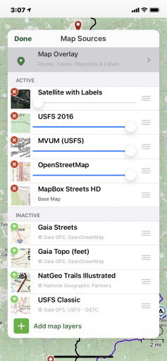
If you click the map layer button on the top right you can add multiple maps
I suggest going premium if you’re going to be exploring more often, Gaia has deals all the time going.
248E6459-5D46-4D72-A91F-9CD2470030F6.png
With the map overlays you can get a pretty good idea of where you’re going.
 
  • Like
Reactions: Broke

Atc210

Rank IV
Member

Enthusiast III

1,253
Columbia, MO, USA
First Name
Adam
Last Name
D
Member #

25836

I have the premium membership just don’t fully understand the overlays yet. The only one I am missing from you post is MapBox Streets HD. It seems to be hidden or potentially no longer available. Which Map Layer is it found under and did it get renamed?

Really appreciate you help.
 
  • Like
Reactions: Broke

UploadAdventure

Rank IV
Launch Member

Enthusiast III

1,277
Dixon, MO, USA
First Name
Rich
Last Name
Monsalvo
Member #

21122

I have the premium membership just don’t fully understand the overlays yet. The only one I am missing from you post is MapBox Streets HD. It seems to be hidden or potentially no longer available. Which Map Layer is it found under and did it get renamed?

Really appreciate you help.
Yeah you have to search through the maps.
You can add them to the layer section.
 
  • Like
Reactions: Broke

Atc210

Rank IV
Member

Enthusiast III

1,253
Columbia, MO, USA
First Name
Adam
Last Name
D
Member #

25836

Read through this thread again and saved the links provided. I have a question though, why is this information not making it to the Overland Bound Maps? We are a community and many of the searches could be streamlined by having a one stop shop or appropriate means to keep the Overland Bound Maps somewhat current. To be honest (take this with a grain of salt as I am new to Overlanding) but the Overland Bound Map was pretty useless during my trip from MO to ID. I found other apps such as onX Offroad, iOverlander and Gaia to have much more information to include marked primitive camping areas and trails.

How does information get added to the Overland Bound Map?
 
  • Like
Reactions: Broke

UploadAdventure

Rank IV
Launch Member

Enthusiast III

1,277
Dixon, MO, USA
First Name
Rich
Last Name
Monsalvo
Member #

21122

Read through this thread again and saved the links provided. I have a question though, why is this information not making it to the Overland Bound Maps? We are a community and many of the searches could be streamlined by having a one stop shop or appropriate means to keep the Overland Bound Maps somewhat current. To be honest (take this with a grain of salt as I am new to Overlanding) but the Overland Bound Map was pretty useless during my trip from MO to ID. I found other apps such as onX Offroad, iOverlander and Gaia to have much more information to include marked primitive camping areas and trails.

How does information get added to the Overland Bound Map?
Fact. Map here isn’t that great.
I’m sure a moderator can get involved and explain some more / add links to a map forum.
 
  • Like
Reactions: Broke