Arizona Overlanders

  • HTML tutorial

1Louder

Rank VI
Launch Member

Member II

4,187
AZ
First Name
Chris
Last Name
K
Member #

1437

Ham/GMRS Callsign
K1LDR
New member! figured I'd sound off here. far east Mesa. hope to meet up with some of you guys.
just got back from camping up in Young
Welcome. Punkin Center to Young is a good trip if you haven't done it yet.
 

Pattio2

Rank II
Launch Member

Enthusiast I

404
Maricopa, AZ, USA
First Name
Patrick
Last Name
McIver
Member #

1912

I was looking at a few roads/trails. I need to find a good map or GPS. Google dosent name all the roads and isn't that accurate in my opinion. Any suggestions?
 

1Louder

Rank VI
Launch Member

Member II

4,187
AZ
First Name
Chris
Last Name
K
Member #

1437

Ham/GMRS Callsign
K1LDR
I was looking at a few roads/trails. I need to find a good map or GPS. Google dosent name all the roads and isn't that accurate in my opinion. Any suggestions?
USFS Raster maps in the app called GAIA are the best. Not available everywhere but most areas on AZ are covered. If there is not a raster map other traditional topo maps are available. You can look at TrailsOffroad.com for ideas. Lots of trails are being mapped. FunTreks books or app (App is big bucks!)

I run Gaia on an iPad with a RAM mount in my FJ. I back it up with my phone.


Sorry if this isn't the best example from the app. I normally wouldn't have the detailed info on the left displayed. You can read a review here: http://www.4xoverlandadventures.com/navigation-app-choice-gaia-gps/

There are also online versions: https://www.gaiagps.com/map/#?lat=33.2808&lon=-111.1645&zoom=15

Not sure if a free account will get you the USFS Raster maps as a layer but it is worth checking out.
 
Last edited:
  • Like
Reactions: Livin the life

Pattio2

Rank II
Launch Member

Enthusiast I

404
Maricopa, AZ, USA
First Name
Patrick
Last Name
McIver
Member #

1912

USFS Raster maps in the app called GAIA are the best. Not available everywhere but most areas on AZ are covered. If there is not a raster map other traditional topo maps are available. You can look at TrailsOffroad.com for ideas. Lots of trails are being mapped. FunTreks books or app (App is big bucks!)

I run Gaia on an iPad with a RAM mount in my FJ. I back it up with my phone.


Sorry if this isn't the best example from the app. I normally wouldn't have the detailed info on the left displayed. You can read a review here: http://www.4xoverlandadventures.com/navigation-app-choice-gaia-gps/
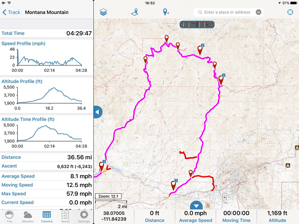
Thank you! I do have GAIA on my iPad mini but I had a hard time figuring out what layers to use. I really appreciate your help! I'm checking it out now.
 

Chris460

Rank 0

Contributor I

60
Hi everyone! I live south of South Mountain. Unfortunately traveling a lot for work at the moment. So more of a remote admirer. Also my rig is currently grounded due to the Takata airbag recall. Really annoying.
 
  • Like
Reactions: Gunnermoose

Gunnermoose

Rank V
Launch Member

Advocate II

2,741
Mesa, Arizona
Member #

1599

AZ people. Myself and @1Louder are planning a run to explore the Paria Plateau Labor Day weekend. It is the area above Vermillion Cliffs. The overall area is located about 2 hours north of Flagstaff around the Marble/Glen Canyon area.

If you are interested please let me know.
 

TN_4Runner

Rank V
Launch Member

Enthusiast III

2,064
Southside, TN, USA
First Name
Bud
Last Name
Bud
Member #

2121

IMG_9059.PNG Just signed up and was looking around and came across this thread. Good to see there is somewhat of a group in AZ.

Live in Gilbert and I have a 2007 Land Rover LR3. Haven't done anything yet beside tired but in the next month it will have a roof top tent and rack.

Hopefully get to go out with a few of you all! [emoji106]

Anyone have anything planned for December2016?
 
Last edited:
  • Like
Reactions: Gunnermoose

TN_4Runner

Rank V
Launch Member

Enthusiast III

2,064
Southside, TN, USA
First Name
Bud
Last Name
Bud
Member #

2121

Ok awesome. Seems like you two are the most active. I would be down to go anywhere but I won't be back in Arizona until the end of November. I'd be down to go anytime I'm home. I'll keep in touch and maybe we can talk closer then to see what we are all doing.
 
  • Like
Reactions: Gunnermoose

TN_4Runner

Rank V
Launch Member

Enthusiast III

2,064
Southside, TN, USA
First Name
Bud
Last Name
Bud
Member #

2121

I know all about that. Too many trips there for me.

I worked in Lebanon for awhile after I retired from the Marines.
Awesome! I was Army for 7.5 years and now I'm doing diplomatic security. Trying to get a hang of this forum thing. Looking forward to doing as many trips as I can when I get back and it would be awesome to go with a group.
 
  • Like
Reactions: Gunnermoose

1Louder

Rank VI
Launch Member

Member II

4,187
AZ
First Name
Chris
Last Name
K
Member #

1437

Ham/GMRS Callsign
K1LDR
We go out all the time.

I'm not a vet but my dad is.
 
  • Like
Reactions: TN_4Runner

Chris460

Rank 0

Contributor I

60
@Gunnermoose if memory serves me right you are also a ham. Do you monitor a particular frequency while out on the trail. I will only be able to do a family day trip but want to go on the air a bit this weekend. Would love to check in with you to see how the trip to the plateau is going.
 

1Louder

Rank VI
Launch Member

Member II

4,187
AZ
First Name
Chris
Last Name
K
Member #

1437

Ham/GMRS Callsign
K1LDR
Just finished another 850+ miles trip up to Vermillion Cliffs/Paria Plateau and further exploration on the eastern edge of the North Rim. New "secret" camping spots have been mapped out. We need to return to the Paria Plateau again because more exploration needs to take place. We were unable to go up Cottonwood Canyon Rd do to bad weather in the area. Next time it will be on the to-do list.