Tips for Paper Maps

  • HTML tutorial

Fozzy325

Rank V
Launch Member

Influencer II

2,808
Calgary, AB, Canada
Member #

15226

I thought of making this thread where I will keep updating this page with relevant tips for Paper maps.

1. Water proofing and ruggedising maps
This technique will reduce weight with each map and waterproof it whilst keeping it flexible.
  • Get one paper map you want to waterproof
  • Buy a roll of Clear Self Adhesive Fablon
  • Layer the Fablon on the front of the map
  • Get an Iron and set it to silk, Iron the back paper side of the map
  • Run the bath and fill it partially full
  • Place map in the Bath and let it soak for 10 min
  • remove from bath and peal the paper away from the Fablon
  • At this point you will notice all the map coloured ink has stayed on the fablon
  • Lay out flat and dry naturally
  • once dry spray the back with hairspray, leave to dry
You will now have a map that is water proof that you can scrunch, fold and you don't need a map case, it will also reduce the weight so you can keep more maps.
You can now also use a sharpie on the map. To clean it you can use an eraser or metal polish swabs. (Metal Polish swabs/wool can then be used to start fires)

2. Folding Paper Maps
Lear n how to fold a map the correct way. By learning how to fold a map the correct way it will reduce the chance of ripping the map when unfolding it. Always fold the map and put it into the map case with your current location in the centre or slightly off centre (Below Centre) with the direction you are travelling closer to the top.
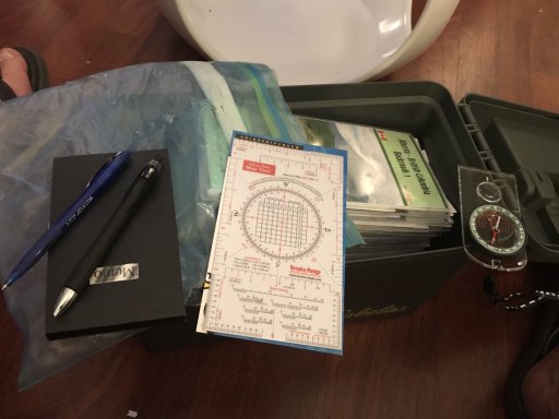
3. Map cases
Make sure you have a double sided map case you has transparent sides. Before getting out of the shelter make sure you fold the map in such a way that your total daily travel is available on the front and back side. This will remove the need to keep on taking the map in and out causing wear and tares.
Make sure the Map case can fit into the Map pocket in the Jacket, (Map pockets are the vertical zipper pockets beside the main zip that looks like it allows access to the inside of the jacket.) THese are not the Breast Pockets.

4. Neighbouring Maps
When going out to an area with 1:25000, and 1:10000 maps it is always a good idea to have the next maps North, West, South, East, NW, SW, NE, SE of the current map you are going to be playing on. If you have to bug out you will have at least the knowledge of the escape routes around you.

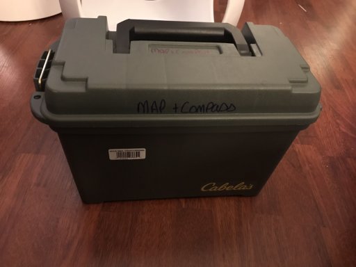
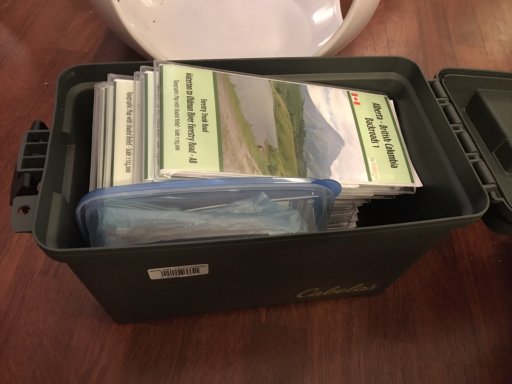
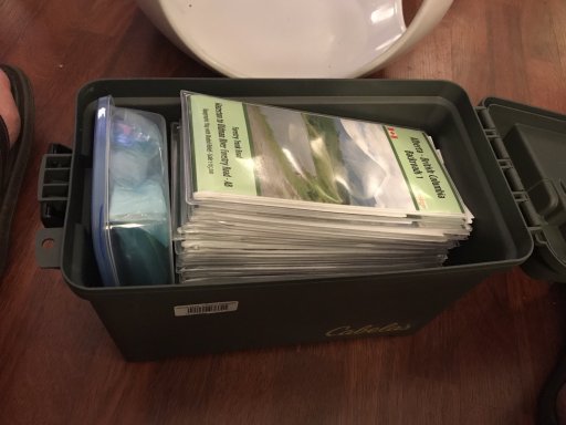
5. Ammo tin map storage
With Correctly folded Maps they will fit exactly into a 5.56 NATO ammo tin, By doing this you can keep at least 20 maps (Flat) in the Ammo Tin. With a 7.62 Nato tin they will fit perfectly on the edge of the map
 

Ron W.

Rank VI
Launch Member

Off-Road Ranger I

3,308
Herriman, UT, USA
First Name
Ron
Last Name
Wilkinson
Member #

4990

Ham/GMRS Callsign
WRQT933
Service Branch
US Navy
Excellent thread. Please keep it up.
 

Plasmajab

Rank IV

Off-Road Ranger I

937
Quinte West, Ontario, Canada
First Name
Ian
Last Name
Howard
Ham/GMRS Callsign
VA3IRA
Mac tac. That's what we use, and the best part of it is that you can write on them with Staetler Permanent markers, and they will come clean with hand sanitizer. So you can put all your gridpoints and bearing and notes on the map, and they will stay. But they erase off once the job is done.
 

Plasmajab

Rank IV

Off-Road Ranger I

937
Quinte West, Ontario, Canada
First Name
Ian
Last Name
Howard
Ham/GMRS Callsign
VA3IRA
Oh, and those pouches you can get (page protectors) can also work the same way if you have templates for grids or bearings and want to resuse them. Or if you have to print your topo map.
 

Nickzero

Rank VI
Launch Member

Influencer II

4,521
Greenville, SC, USA
First Name
Nicholas
Last Name
Dugdale
Member #

12727

I had designed Morse Code cards once. I used this same waterproofing method to assure they wouldn't get ruined out in the field. Cool thing was they were on glow in the dark ink paper! So once laminated cut and perfected I would hand them out to friends and they found them useful at night too.
 
  • Like
Reactions: Retinens803

Rolando

Rank V
Launch Member

Member III

2,796
Lovettsville, VA
First Name
Roland
Last Name
Woldt
Member #

15186

So the other interesting question is where to get good maps. What I've seen at REI and other stores are very specialized maps for hikers, etc. But I have not seen either good overview maps that were not be in a book format, or in a more local scale of 1:50000 or similar.
What do you guys recommend?
 

Fozzy325

Rank V
Launch Member

Influencer II

2,808
Calgary, AB, Canada
Member #

15226

So the other interesting question is where to get good maps. What I've seen at REI and other stores are very specialized maps for hikers, etc. But I have not seen either good overview maps that were not be in a book format, or in a more local scale of 1:50000 or similar.
What do you guys recommend?
Have you tried
https://store.usgs.gov/maps
 

Laud

Rank VI
Launch Member

Influencer I

3,145
Southeast Arlington TX
First Name
Laud
Last Name
Maroney
Member #

7010

Ham/GMRS Callsign
-KG5QHC-
Service Branch
Air Force and Army
Excellent info!!!!

But what is the paper stuff you speak of?
 
  • Haha
Reactions: Matt L.

MOAK

Rank V
Launch Member

Off-Road Ranger I

2,865
Wernersville Public Library, North Reber Street, Wernersville, PA, USA
First Name
Donald
Last Name
Diehl
Member #

0745

Ham/GMRS Callsign
WRPN 506
So the other interesting question is where to get good maps. What I've seen at REI and other stores are very specialized maps for hikers, etc. But I have not seen either good overview maps that were not be in a book format, or in a more local scale of 1:50000 or similar.
What do you guys recommend?
National Geographic; world wide topo maps with single and two track roads, Latitude 40*; primarily Colorado, and 4 corners region; Purple Lizard; eastern seaboard on over into WV and Ohio. I carry all of these and keep ordering more. I also carry many different maps published by the National and State Forest Services and Bureau of Land Management Services. NG, Latitude 40* and Purple Lizard are my Go To sources. The only electronic map I use is the Google Maps app on my i-phone, but only on pavement. Once off pavement I shut down electronic devices and rely on good old fashioned paper maps and seat of the pants navigation.
 

PCO6

Rank V
Launch Member

Member III

2,268
Newmarket, Ontario
First Name
Stew
Last Name
Beatty
Member #

12534

  • Like
Reactions: VI Overlander

PCO6

Rank V
Launch Member

Member III

2,268
Newmarket, Ontario
First Name
Stew
Last Name
Beatty
Member #

12534

Last edited:

titicaca

Rank IV

Enthusiast III

1,135
Calgary
Does anyone use "Backroad Mapbooks"?
Yes. Out in the west Backroad Mapbooks detail is excellent. Despite being a big fan and contributor of OpenStreetMap while panning a trip I noticed it still lacks detail compared to the Backroad Mapbooks.
 
  • Like
Reactions: PCO6

PCO6

Rank V
Launch Member

Member III

2,268
Newmarket, Ontario
First Name
Stew
Last Name
Beatty
Member #

12534

Yes. Out in the west Backroad Mapbooks detail is excellent. Despite being a big fan and contributor of OpenStreetMap while panning a trip I noticed it still lacks detail compared to the Backroad Mapbooks.
I agree. I think they have the whole country covered. :smiley:
 

old_man

Rank V
Launch Member

Member III

2,827
Loveland, Colorado
First Name
Tom
Last Name
Houston
Member #

8300

Ham/GMRS Callsign
WØNUT Extra
For Colorado Maps, there is only one source in my book latitude40maps.com

They are actually cartographers of the highest caliber. Their maps are works of art suitable for framing. They also print on Tyvek or similar so their maps will not tear or get wet.

Take a minute to check them out. You can find their maps at quality outfitters up and down the Rockies, as well as online.

If you want to do the trail of a lifetime, check out their map for White Rim Trail. It is located just west of Moab, Utah. It is 102 miles of dirt starting on the Colorado River Rim, heading down to where it meets the Green River, then heading up the Green River Rim. It is Latitude40's Moab West Trails TOPO map. You can just sit and stare at it for hours. Do a search for pics for White Rim Trail.
 
  • Like
Reactions: MOAK and Matt L.

Matt L.

Rank V
Launch Member

Enthusiast III

1,836
Midland, TX
Member #

7395

Does anyone use "Backroad Mapbooks"? It's a great source for Canadian maps.

Great thread btw!

Wish I had the spiral bound version like these. I use the Delorme Atlas & Gazetteer and they are always falling apart at the seams.
 

Matt L.

Rank V
Launch Member

Enthusiast III

1,836
Midland, TX
Member #

7395

For Colorado Maps, there is only one source in my book latitude40maps.com

They are actually cartographers of the highest caliber. Their maps are works of art suitable for framing. They also print on Tyvek or similar so their maps will not tear or get wet.

Take a minute to check them out. You can find their maps at quality outfitters up and down the Rockies, as well as online.

If you want to do the trail of a lifetime, check out their map for White Rim Trail. It is located just west of Moab, Utah. It is 102 miles of dirt starting on the Colorado River Rim, heading down to where it meets the Green River, then heading up the Green River Rim. It is Latitude40's Moab West Trails TOPO map. You can just sit and stare at it for hours. Do a search for pics for White Rim Trail.
These maps look great.
I did the White RIm in 2015. It is amazing!