

Hi folks,
I'm planning a 3-5 day trip into the wastelands of SE Oregon. Having done OBDR Route 4 last year and dabbled with a few routes in the meantime, I've got a few goals in mind for this trip:
When I started planning this, I began with a rough route in mind - meet in Bend, travel south down to the Hart Mountain National Antelope Refuge so we can all feel like real South African overlanders on the savannah, do some red-neckin in the dune of Christmas Valley on the way, pretend we're the first people at Burning Man at the Alvord Desert, and head due North back to the glistening blacktop of Highway 20 - and home.
Here's what that looks like, roughly. At the time, Google Earth's Panoramio layer was still enabled so I cross referenced with satellite and topo to identify relevant points of interest in a loop. Admittedly, I bias toward abandoned and weathered structures, but look at that topography! Arid desert, alkali lakes, stoic rock formations, sand dunes, frickin CAVES?! It's a GD wonderland.

Here's the KMZ
Next I started to break out trail days and routes. Let me tell you, this is the tedious part. Since I'm committed to keeping us on dirt, I'm carefully cross referencing 4WD roads from the USGS topo maps and then corroborating the location from satellite. I'm also biasing toward roads that look crappier, knowing that there is almost always an alternate and parallel route that is pretty smooth. I have no way of knowing what will and will not be gated, so I fully expect our way to be blocked and group routefinding to commence. If we're lucky, some of us might even get stuck so we can use our expensive recovery gear!
Day 1 starts off with an easy 63.3mi off-pavement journey. I'm thinking we'll meet up in Bend on the morning of the first day, knowing we'll require some fudge time to get on the trail. Perhaps breakfast beers as well. Once we're on the trail we'll start with a run up through the active Pine Mountain Observatory, sadly too early for any tours. A moderate descent leads us to picking through 4WD roads and a slight detour up to China Hat OHV area and lookout, which will hopefully yield some nice views and stimulating obstacles. Depending on the group's comfort level, we may instead opt to access the Fox Butte Lookout via Lava Cicle Cave, a seldom visited lava tunnel. From Fox Butte we drive like we're in Baja over power line access roads to Derrick Cave and the site of our first camp in what appears to be a secret clearing in the middle of a huge lava field. My hope is that we get to do our tour of Derrick Cave at night.

Here's the KMZ
After morning calisthenics (wait, what did he say?!) and large quantities of bacon, we'll embark on Day 2. Day 2 will be a bigger day. We'll start by shooting the gap between two ancient lava fields, eventually arriving at Ice Cave - another large lava tube - and eventually the famous Crack in the Ground. Yes, that is a noun, no it has nothing to do with a trailer park. Of course Hole in the Ground is another story. Christmas Valley delivers lunch and a refuel to bolster our spirits for a short leg across the sand at the Christmas Valley Sand Dunes. That's right folks, get your Defender and keffiyeh ready: we're dune running.
After that we follow a long stretch of true overland desolation, passing such landmarks as Dead Horse Lake (not a lake) and Snipe Lake (also not a lake). By-the-by we arrive at our campsite on the shores of beautiful Lake Albert, which will hopefully still be there when we visit. Thats just over a 100mi run, so we'll see how everyone is feeling.
Here's the KMZ
I'm tempted to have us run a little longer on Day 1 to make it to the hot springs at Hart Mountain for Camp 2, but as I mentioned all I know about these roads is that something in space took a photo of them sometime in the last couple years. I also don't have a trip date yet and moisture could heavily impact our travel velocity.
We'll get an early start on Day 3 for a 90-100 mile run. We'll be cutting perpendicularly across some significant ridges as we climb into the Antelope Preserve, so I expect some interesting off roading. We should arrive at Hart Mountain hot springs around lunch for a quick soak before we drop down into the Preserve itself, meandering through dried up watering holes as we descend off from the slopes of Hart Mountain. We'll end the day with a visit to Shirk Ranch and a climb up what may or may not be a quite technical jeep trail up a secluded side canyon al0ng a stream. I have absolutely no doubt we'll wake up with a herd of antelope silhoutted against the morning sun on the canyon cliff edge. If we're not feeling up to a disused jeep trail at the end of a day, 10 more miles delivers us to an alternative camp above the Spaulding Ranch on the other side of the valley from Shirk where we will opine on the historical relationship of these two pioneers and their remote homesteads.

Here's the KMZ
Next up, I'll add days 4 and 5 as I get to them.
So that's where YOU come in! If you have any information or experience with this area, I'd love to hear it. Not-to-miss destinations? Precautionary tales? Let's hear them! If you want to come, let me know when you are free! Right now I'm thinking June - July - August timeframe, biasing towared June as I'd like to have a little moisture in the soil left before the region gets broiled like my morning frittata.
***UPDATE***
Trip dates:
Thursday, June 28 - Sunday, July 1, 2018
Meet:
9AM at the BP in Bend near CVT (note CVT opens at 9AM in case of gear crisis/upgrade fever)
304 NE Greenwood Ave, Bend, OR
https://goo.gl/maps/Z6hBkbef2mA2
Group Gear:
TBD when we have a final attendee list (will update this post). I always bring a groover, no poop holes allowed on my trips. I include chainsaw on the group gear list and will bring one.
Meal Plan:
TBD when we have a final attendee list (will update this post). I like to divide meal responsibility so people/pairs alternate meal responsibility for the group. Gives everyone a chance to enjoy eachother's fine trail cooking and helps bring everyone together. Typical is group breakfast, BYO lunch, group apps, group dinner, and group dessert. BYO beverages.
Etiquitte and Preparedness:
-Be pepared and don't be an asshole.
-If you haven't yet, or you're a newbie, take a moment to review the checklists from NWOL for stuff you should bring and NOT expect anyone else to have for you. Take some of this with a grain of salt and don't go out and buy a hi-lift, chainsaw, camp chef, etc.
-If you have all season tires on your rig, consider this your opportunity to upgrade to a good A/T tire. We're going to be 400 or so miles on dirt, gravel, and rocks and a couple of flats will result in leaving your rig somewhere it's hard to get back. A/T tires are built for lower pressure operation and have tougher tread and sidewalls to stand up to abuse.
-Bring containers for 2 gallons of water per person per day. We will have a few opportunities to refill, but this can often be fairly inconvenient.
-Fuel range shouldn't be an issue on this trip, but it's not a bad idea to bring some extra. Expect 100 miles or so off road (YMMV) at low speed between fuel stations.
-As an old Eagle Scout, I'm into LNT or Tread Lightly - we'll be packing out all waste (yes, I do mean ALL) and doing trash patrols at campsites.
-On the trail, safety is our top priority and we work together to make sure everyone has a great time and completes the trip.
Communications:
This trip is HAM friendly! KF7UNK right here, I'll post a band plan when we get closer if we have other HAMs. I don't have (or want) a CB so if you've been considering it, now is a great time to get your Technician's license!
Navigation:
All routes will be posted in Gaia with public access in the next few weeks. Highly recommend you purchase the app so you can follow along.
!!!Important!!!
I need final commitment to the trip no later than June 8 to give me time to put together the meal plan and group gear list. Please, be honest with yourself and only commit if you can make it. If you can't, we'll catch you next year.
I'm planning a 3-5 day trip into the wastelands of SE Oregon. Having done OBDR Route 4 last year and dabbled with a few routes in the meantime, I've got a few goals in mind for this trip:
- Maximize off-road/dirt time, even if it's obviously less efficient than paved routes.
- Bias toward likely more difficult roads (ie, keep it spicy!)
- Plan the trip completely from topos/satellite images
- Include a healthy helping of destinations - lookouts, caves, hot springs, etc - it's more fun with a mission!
When I started planning this, I began with a rough route in mind - meet in Bend, travel south down to the Hart Mountain National Antelope Refuge so we can all feel like real South African overlanders on the savannah, do some red-neckin in the dune of Christmas Valley on the way, pretend we're the first people at Burning Man at the Alvord Desert, and head due North back to the glistening blacktop of Highway 20 - and home.
Here's what that looks like, roughly. At the time, Google Earth's Panoramio layer was still enabled so I cross referenced with satellite and topo to identify relevant points of interest in a loop. Admittedly, I bias toward abandoned and weathered structures, but look at that topography! Arid desert, alkali lakes, stoic rock formations, sand dunes, frickin CAVES?! It's a GD wonderland.
Here's the KMZ
Next I started to break out trail days and routes. Let me tell you, this is the tedious part. Since I'm committed to keeping us on dirt, I'm carefully cross referencing 4WD roads from the USGS topo maps and then corroborating the location from satellite. I'm also biasing toward roads that look crappier, knowing that there is almost always an alternate and parallel route that is pretty smooth. I have no way of knowing what will and will not be gated, so I fully expect our way to be blocked and group routefinding to commence. If we're lucky, some of us might even get stuck so we can use our expensive recovery gear!
Day 1 starts off with an easy 63.3mi off-pavement journey. I'm thinking we'll meet up in Bend on the morning of the first day, knowing we'll require some fudge time to get on the trail. Perhaps breakfast beers as well. Once we're on the trail we'll start with a run up through the active Pine Mountain Observatory, sadly too early for any tours. A moderate descent leads us to picking through 4WD roads and a slight detour up to China Hat OHV area and lookout, which will hopefully yield some nice views and stimulating obstacles. Depending on the group's comfort level, we may instead opt to access the Fox Butte Lookout via Lava Cicle Cave, a seldom visited lava tunnel. From Fox Butte we drive like we're in Baja over power line access roads to Derrick Cave and the site of our first camp in what appears to be a secret clearing in the middle of a huge lava field. My hope is that we get to do our tour of Derrick Cave at night.
Here's the KMZ
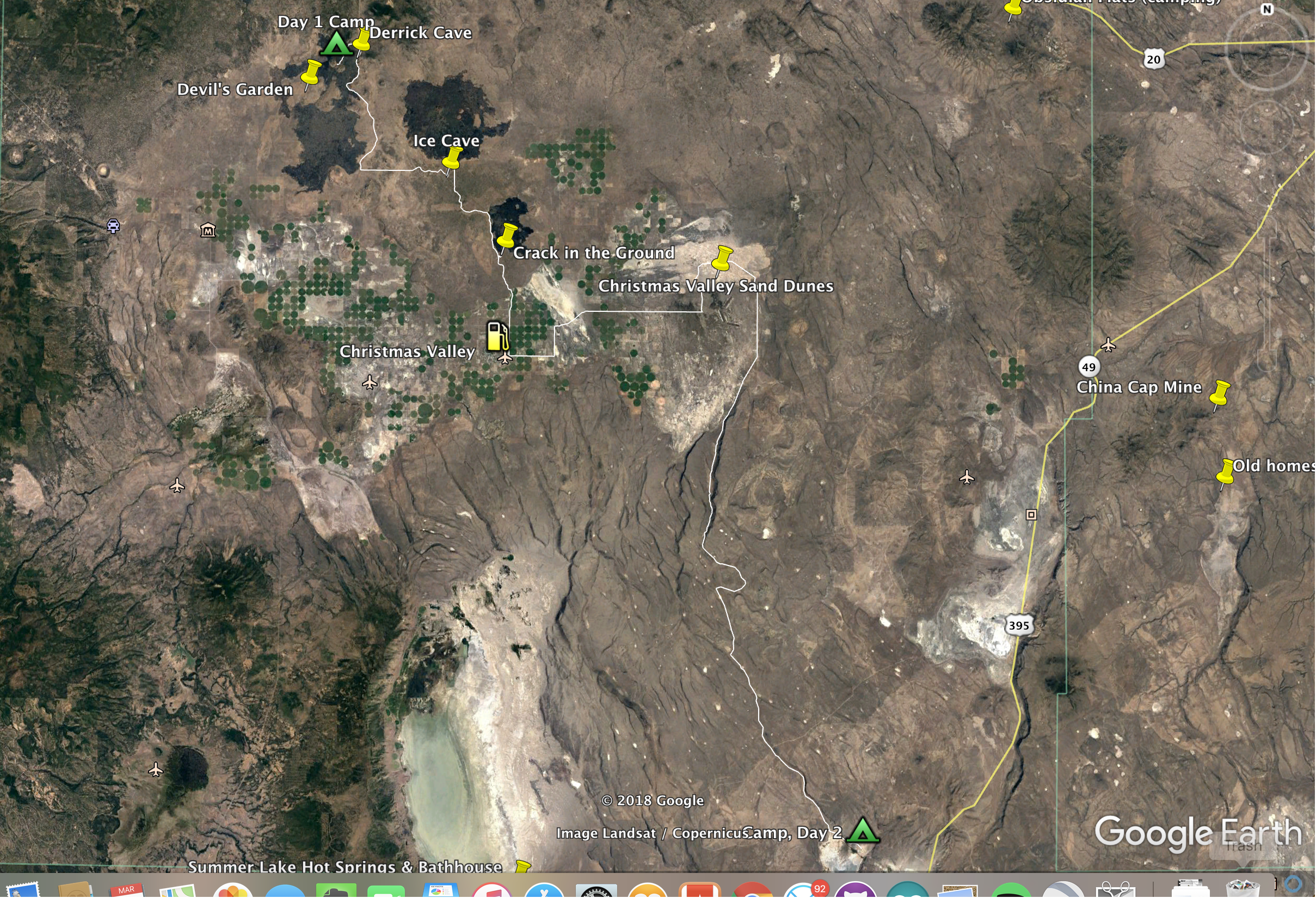
After morning calisthenics (wait, what did he say?!) and large quantities of bacon, we'll embark on Day 2. Day 2 will be a bigger day. We'll start by shooting the gap between two ancient lava fields, eventually arriving at Ice Cave - another large lava tube - and eventually the famous Crack in the Ground. Yes, that is a noun, no it has nothing to do with a trailer park. Of course Hole in the Ground is another story. Christmas Valley delivers lunch and a refuel to bolster our spirits for a short leg across the sand at the Christmas Valley Sand Dunes. That's right folks, get your Defender and keffiyeh ready: we're dune running.
After that we follow a long stretch of true overland desolation, passing such landmarks as Dead Horse Lake (not a lake) and Snipe Lake (also not a lake). By-the-by we arrive at our campsite on the shores of beautiful Lake Albert, which will hopefully still be there when we visit. Thats just over a 100mi run, so we'll see how everyone is feeling.
Here's the KMZ
I'm tempted to have us run a little longer on Day 1 to make it to the hot springs at Hart Mountain for Camp 2, but as I mentioned all I know about these roads is that something in space took a photo of them sometime in the last couple years. I also don't have a trip date yet and moisture could heavily impact our travel velocity.
We'll get an early start on Day 3 for a 90-100 mile run. We'll be cutting perpendicularly across some significant ridges as we climb into the Antelope Preserve, so I expect some interesting off roading. We should arrive at Hart Mountain hot springs around lunch for a quick soak before we drop down into the Preserve itself, meandering through dried up watering holes as we descend off from the slopes of Hart Mountain. We'll end the day with a visit to Shirk Ranch and a climb up what may or may not be a quite technical jeep trail up a secluded side canyon al0ng a stream. I have absolutely no doubt we'll wake up with a herd of antelope silhoutted against the morning sun on the canyon cliff edge. If we're not feeling up to a disused jeep trail at the end of a day, 10 more miles delivers us to an alternative camp above the Spaulding Ranch on the other side of the valley from Shirk where we will opine on the historical relationship of these two pioneers and their remote homesteads.
Here's the KMZ
Next up, I'll add days 4 and 5 as I get to them.
So that's where YOU come in! If you have any information or experience with this area, I'd love to hear it. Not-to-miss destinations? Precautionary tales? Let's hear them! If you want to come, let me know when you are free! Right now I'm thinking June - July - August timeframe, biasing towared June as I'd like to have a little moisture in the soil left before the region gets broiled like my morning frittata.
***UPDATE***
Trip dates:
Thursday, June 28 - Sunday, July 1, 2018
Meet:
9AM at the BP in Bend near CVT (note CVT opens at 9AM in case of gear crisis/upgrade fever)
304 NE Greenwood Ave, Bend, OR
https://goo.gl/maps/Z6hBkbef2mA2
Group Gear:
TBD when we have a final attendee list (will update this post). I always bring a groover, no poop holes allowed on my trips. I include chainsaw on the group gear list and will bring one.
Meal Plan:
TBD when we have a final attendee list (will update this post). I like to divide meal responsibility so people/pairs alternate meal responsibility for the group. Gives everyone a chance to enjoy eachother's fine trail cooking and helps bring everyone together. Typical is group breakfast, BYO lunch, group apps, group dinner, and group dessert. BYO beverages.
Etiquitte and Preparedness:
-Be pepared and don't be an asshole.
-If you haven't yet, or you're a newbie, take a moment to review the checklists from NWOL for stuff you should bring and NOT expect anyone else to have for you. Take some of this with a grain of salt and don't go out and buy a hi-lift, chainsaw, camp chef, etc.
-If you have all season tires on your rig, consider this your opportunity to upgrade to a good A/T tire. We're going to be 400 or so miles on dirt, gravel, and rocks and a couple of flats will result in leaving your rig somewhere it's hard to get back. A/T tires are built for lower pressure operation and have tougher tread and sidewalls to stand up to abuse.
-Bring containers for 2 gallons of water per person per day. We will have a few opportunities to refill, but this can often be fairly inconvenient.
-Fuel range shouldn't be an issue on this trip, but it's not a bad idea to bring some extra. Expect 100 miles or so off road (YMMV) at low speed between fuel stations.
-As an old Eagle Scout, I'm into LNT or Tread Lightly - we'll be packing out all waste (yes, I do mean ALL) and doing trash patrols at campsites.
-On the trail, safety is our top priority and we work together to make sure everyone has a great time and completes the trip.
Communications:
This trip is HAM friendly! KF7UNK right here, I'll post a band plan when we get closer if we have other HAMs. I don't have (or want) a CB so if you've been considering it, now is a great time to get your Technician's license!
Navigation:
All routes will be posted in Gaia with public access in the next few weeks. Highly recommend you purchase the app so you can follow along.
!!!Important!!!
I need final commitment to the trip no later than June 8 to give me time to put together the meal plan and group gear list. Please, be honest with yourself and only commit if you can make it. If you can't, we'll catch you next year.
Last edited:


