Old Nipissing Road - Ontario

  • HTML tutorial

PCO6

Rank V
Launch Member

Member III

2,268
Newmarket, Ontario
First Name
Stew
Last Name
Beatty
Member #

12534

My wife and I travelled on parts of the Old Nipissing Road this past weekend and I'd recommend it to anyone. We did parts of it and plan to go back to do it from one end to the other. We camped at Grundy Lake Provincial Park for the first part of the week and then Oastler Lake PP for the remainder of it. From Oastler we went to Magnetawan and then headed south from there to Hwy. 518 (about 31 km). It's a beautiful road as seen in Ontario Overland's photos above.

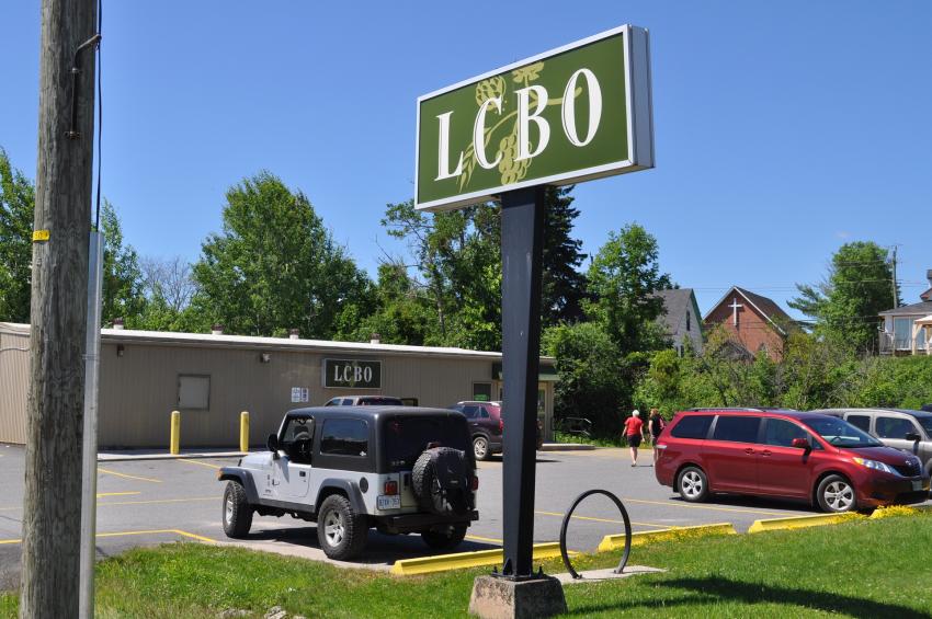
This was our starting point in Magnetawan … don't judge me (lol). To non-Ontarians, the LCBO is the Liquor Control Board of Ontario. It's our archaic, socialistic way of dispensing booze. They open at 10:00 am and we hit the road at about 10:10 with an unopened bottle of rye (whiskey) in the back of the Jeep.


At Hwy. 518 we got off of the Old Nipissing Road and headed west to Isabella Lake which is just west of Orville to locate my grandparent's old cottage. The lake was pretty neat to see as I hadn't been there in almost 50 years. We're going to go back and kayak to the actual site next year.

We returned to Hwy 518 and The Old Nipissing Road to continue our planned trip south to Rosseau (about 24 km). This is the tougher trail part of the Old Nipissing Road and it didn't end well for us. We made it south to just east of Ronsford Lake (about 10 km). We met 4 people on 2 quads and they "strongly recommended" that we turn back. They encountered trees across the trail that they had a hard time getting around. They had to go through the woods to do it. We met another quad driver on our return trip to Hwy 518 and he said the same. I guess the good news is that we drove on the trail for about 20 km. We got to see the hills and rocks from the opposite direction on the way back so we were happy.

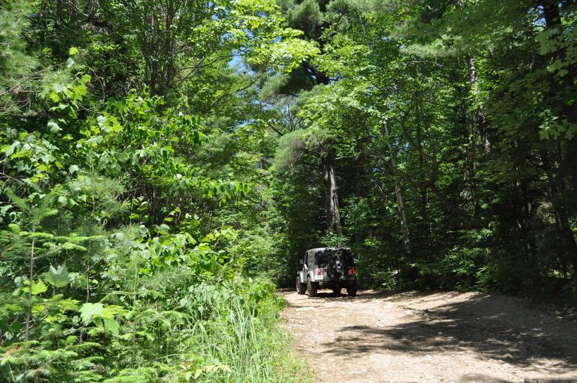
I should have taken more pics of the trail but this is it. There were parts of it where branches were rubbing up against both side of the Jeep.


We also encountered a deer on the trail part. It jumped out of the woods about 40 ft. ahead of us and was neat to see. I told my wife if we slowed down a bit we might find some bears. That didn't go over well.

BTW - we used Backroad Map Books, Cottage Country edition maps and they were easy to follow.
http://www.backroadmapbooks.com/backroad-mapbooks/ontario-backroad-maps/cottage-ontario-backcountry-maps
 
  • Like
Reactions: EJD

Ontario Overland

Rank V
Launch Member

Pathfinder I

2,268
Hanover,Ontario, Canada
First Name
Mike
Last Name
Cerutti
Member #

0939

Sounds like a great trip @PCO6! I’d love to try an run the section south of the 518. I keep hearing conflicting reports of the passability to Rosseau, I’ve seen a few videos from the dual sport guys, it looked pretty tight.
 

PCO6

Rank V
Launch Member

Member III

2,268
Newmarket, Ontario
First Name
Stew
Last Name
Beatty
Member #

12534

Thanks "OO". It was fun while it lasted! I've heard that too. The ATV guys we ran into knew what they were talking about and said sometimes it's good but you can't always count on it. The weather was good for us. I'm not sure I'd like to do it in the spring though. Our biggest concern was meeting a vehicle (Jeep, Toyota, etc. - not an ATV or trail bike) coming the other way. Turning around, backing up or even getting off the trail a bit to pass would have been tough.
 
Last edited:

fjk

Rank 0
Launch Member

Traveler I

60
Kitchener, ON
Member #

16208

@Ontario Overland: Your post here inspired me to explore this during my vacation at the beginning of the July. We were camped @ Restoule provincial park so we (my dad and I in my Jeep) explored from Commanda to Magnetawan one day. After the fact, I realized I did a terrible job at getting photos (but I had the video camera on the windshield running the whole time, so maybe I'll get around to posting some of that).

My tracks from the day:
2018-07-06-OldNipissingRoadNorth_Tracks.jpg
And a few bits of the very north end we covered two days before, en passant:
2018-07-04-OldNipissingRoadNorth_Tracks.jpg
You can see there were only a few sections I didn't/couldn't navigate (starting from the north end):
- From Niagara Road to Alsace Rd.: From the north side, there's a bit of road -- but didn't actually try it because I didn't realize that was part of the track when I drove it. From the south/Alsace Rd. side, tt's a very skinny quad trail now although Google Maps shows a "road". We did explore a couple kms of it though from the south/Alsace Rd. side, though, before bailing.
- The small section between Alsace Rd and Old Nipissing Rd. North out of Commanda is not accessible (or at least I couldn't find it and I believe there's a river crossing there making it impassible).
- Old Nipissing Rd. South out of Commanda to Jerusalem Rd. is also largely inaccessible -- but here, again, we did explore a a few kms of it from the south/Jerusalem Rd. side. At that point, the trail was getting too skinny and mucky and I didn't want to get stuck. (I was flying solo and the deer flies were atrocious and it was 40 degrees in the shade.)

On Rye Rd between Granite Hill Rd. and Jerusalem Rd. we encountered a very lost transport truck (18 wheeler with a full 53' trailer).
2018-07-06-OldNipissingRoad_LostTransport.JPG
We were baffled and astonished that he got through there. As we drove it, we could see where is front axle tracks were barely on the road going through the outside of many bends while the trailer tracks were hanging off the road on the inside! The very bewildered driver was quite happy to receive directions for a route back to pavement to get to Port Loring. We think he got off Hwy 11 @ South River instead of getting off at Trout Creek. So much for that "shortcut" from Hwy. 11!

I was able to cross the bridge on Jerusalem Rd. Apparently they repaired the railings AND widened the railings. I'd suggest you bring a spotter though. It's barely wide enough for a full size vehicle and you definitely don't want to drop a tire off the beams, but it was certainly strong enough (there's large steel beams below the wooden surface). As always, tread wisely.

20180706_122031.jpg

Just past the bridge, I too, found that old car:
IMG_6801_resize.JPG

Once we got back to the Old Nipissing rd. track, we headed north along the impassible quad trail towards Commanda as far as I cared to (it got pretty mucky a few kms in -- even during a drought). That section is 4x4 only, and expect to lose a bit of paint as it's really only quad sized in a few places. So I turned around and continued south towards Rye. We explored around Rye, checked out the cemetery there, read up on the various (and very informative) history placards along the way (look for randomly place white placards).

Just south of Rye there's a snowmobile trail that peels off to the right which follows the old Nipissing track. A 4x4 can do it (and we did, in fact, cover this whole section stopping once to remove a couple small fallen trees). I'd call it a level 2 trail (based on the OF4WD ratings). During wet seasons I would not recommend travelling it. This trail drops you off in "downtown" bummer's roost! I continued south along Parceley Road out of Bummer's Roost until we came across the placard for "Wattenwyle". At that spot, there's a road that peels off to the right there which is a 1-track gravel road that follows the old Nipissing road track further south to meet up with Youthdale Rd (a private camp road) where it branches off Nipissing Rd north. I'd rate that section a 1+ -- I followed a pickup truck pulling a trailer with quads on part of it.

From there, it's an easy gravel road pretty much all the way to 124 with a few more informational placards along the way. We found the historic marker in Magnetewan for the Nipissing-Rosseau road, had some lunch and some ice cream and started meandering our way back via other interesting looking side roads and bypasses of the "impassable" parts we actually went through. And we were back at camp for dinner!

Totally worth the drive! Looking forward to the southern half -- when I get to it!
 

PCO6

Rank V
Launch Member

Member III

2,268
Newmarket, Ontario
First Name
Stew
Last Name
Beatty
Member #

12534

Great write up fjk! We might have been out there at the same time except we were on the section south of Magnetawan (see post #21). We also plan to go back but to do the northern section. I might tackle the Seguin Falls south to Rosseau section again. That was the part we had to abandon due to fallen trees that were blocking the trail. BTW - we definitely didn't see any tractor trailers!
 
  • Like
Reactions: Ontario Overland

fjk

Rank 0
Launch Member

Traveler I

60
Kitchener, ON
Member #

16208

Great write up fjk! We might have been out there at the same time except we were on the section south of Magnetawan (see post #21). We also plan to go back but to do the northern section. I might tackle the Seguin Falls south to Rosseau section again. That was the part we had to abandon due to fallen trees that were blocking the trail. BTW - we definitely didn't see any tractor trailers!
Thanks! Bring your saw next time -- I needed it twice that day! Perhaps we could plan a trip for the southern part sometime later this year? I'm still building out my camping setup, so not quite ready for true overlanding yet.

Cheers!

Sent from my Pixel using OB Talk mobile app
 
Last edited:
  • Like
Reactions: Ontario Overland

PCO6

Rank V
Launch Member

Member III

2,268
Newmarket, Ontario
First Name
Stew
Last Name
Beatty
Member #

12534

Thanks! Bring your saw next time -- I needed it twice that day! Perhaps we could plan a trip for the southern part sometime later this year? I'm still building out my camping setup, so not quite ready for true overlanding yet.

Cheers!

Sent from my Pixel 3 using OB Talk mobile app
I had my wife with me. If she had seen me loading my chain saw into the Jeep she would have refused to go! lol

It would be a fun trip to make with a group.
 
  • Like
Reactions: fjk