

Member III
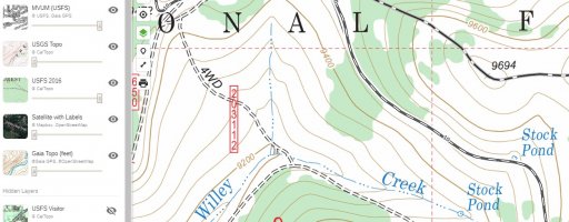
Ok, newbie question. So I'm planning my first day trip to learn a bit and see what is nearby. My question is about legal roads to use. In the first picture below you'll see a Gaia map where I've got two layers active, the Motor Vehicle Use Map and the USFS map. You'll notice a road labeled "4WD" and numbered 203112. When I look at map legend for the USFS map it says the double dashed line is "Unimproved, 4 wheel drive."
Now the next image I have hidden the USFS map layer and you can only see the MVUM. You'll notice that 203112 is gone. Does this mean that 203112 is not legal to drive on? I nabbed the most recent PDF from the USFS and it agrees with what is shown below, that 4WD route is not listed. In fact, there a many, many of these 4WD routes that aren't on the MVUM. Looking on satellite imagery with Google Earth does show a track there and in many locations that aren't on the MVUM. Not wanting to get busted my first time exploring, do I need to stick to the alternating black/white roads marked on the MVUM or can I go on the unimproved roads on the USFS map from CalTopo?
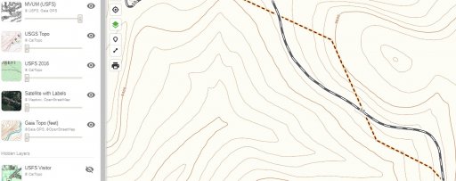
Now the next image I have hidden the USFS map layer and you can only see the MVUM. You'll notice that 203112 is gone. Does this mean that 203112 is not legal to drive on? I nabbed the most recent PDF from the USFS and it agrees with what is shown below, that 4WD route is not listed. In fact, there a many, many of these 4WD routes that aren't on the MVUM. Looking on satellite imagery with Google Earth does show a track there and in many locations that aren't on the MVUM. Not wanting to get busted my first time exploring, do I need to stick to the alternating black/white roads marked on the MVUM or can I go on the unimproved roads on the USFS map from CalTopo?


