US Northwest I want to do the TAT (Trans American Trail) in 2021

  • HTML tutorial

armyRN

Rank V
Launch Member

Member III

1,683
Longview, WA
First Name
Paul
Last Name
Dickinson
Member #

22047

Ham/GMRS Callsign
KI7TSP
Here's the deal. I want to do the TAT in 2021; I have been wanting to for years & I'm not getting any younger (I'm 60 years young). I'm no longer working full time, and it is getting to the point "If not now... when?". I live in WA state.

Link: TransAm Trail – with Sam Correro


TAT map.PNG

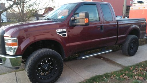
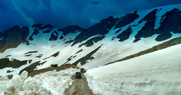
We're talking over 5,000 miles. We'll start in WV (see map above), and then once in ID take the Pacific Ocean Spur to OR and then back to WA. Would be fun to do the Shadow of the Rockies section. They figure 200 miles/day, so figure we'll be gone at least a month. And that's not including the few days to get to the starting point in WV. This isn't a race - I want to enjoy it, but I'm also not going to dawdle. It can be done in a 4x4 Jeep-sized vehicle (might want to reconsider if taking a full-size vehicle) according to what I've read.

So who's done the TAT? Words of advice? I'm all ears.

Anyone else ever wanted to do the TAT but didn't want to take the lead on it? Who would be interested in joining me? I have no problem taking the lead on this.

The start date may depend on when the NWOR is scheduled (dates aren't posted yet), but right now I'm thinking starting the TAT in WV early June (so add in the travel days to get to the starting point). Gotta start planning sometime - can't wait till the last minute.

Overland Adventure.1.jpg
 
Last edited:

Enthusiast III

1,116
South Dayton, NY, USA
First Name
Ronald
Last Name
Howard
Member #

26138

Service Branch
USMC 85'-89'
I am also planning on doing at least part of the TAT this next summer....starting up in PA/NY area and following it for about 10 days before I head back home. I have done camping trips before but almost always local, this will be my first time going actually overlanding that distance. I will be driving a full size rig tho....2008 F250 SuperDuty. From the videos I have seen I should be fine on the Eastern part of the Country, it's not until I get out west that it becomes harder. I will be doing this basically solo, but not alone. No other vehicle.
 

Attachments

Neal A. Tew

US Rocky Mountain Local Expert
Mod Team
Member
Member

Member III

3,817
Pueblo West, CO
First Name
Neal
Last Name
Tew
Member #

12384

Ham/GMRS Callsign
N1TEW
I was kicking around doing CO & UT next year. CO portion passes not far from me so I've done much of it, but not in one go.

You just need to be careful not to get to CO too early in the season because some of the best passes could still be closed. It all depends on how much snow we get between now and then. I think you may squeak through mid June if things go your way.
 

armyRN

Rank V
Launch Member

Member III

1,683
Longview, WA
First Name
Paul
Last Name
Dickinson
Member #

22047

Ham/GMRS Callsign
KI7TSP
I was kicking around doing CO & UT next year. CO portion passes not far from me so I've done much of it, but not in one go.

You just need to be careful not to get to CO too early in the season because some of the best passes could still be closed. It all depends on how much snow we get between now and then. I think you may squeak through mid June if things go your way.

Noted. Thanks!
 
  • Like
Reactions: Neal A. Tew

Neal A. Tew

US Rocky Mountain Local Expert
Mod Team
Member
Member

Member III

3,817
Pueblo West, CO
First Name
Neal
Last Name
Tew
Member #

12384

Ham/GMRS Callsign
N1TEW
This was either California Gulch or Hurricane Pass mid-June last year. It had only been open a day or two.


Keep me posted. I might be game to tag along out here for a state or two if you're interested.

I'd recommend you have someone ahead of you in radio contact when you get to all the tight switchbacks if you're pulling a trailer....
 
  • Like
Reactions: srotier

armyRN

Rank V
Launch Member

Member III

1,683
Longview, WA
First Name
Paul
Last Name
Dickinson
Member #

22047

Ham/GMRS Callsign
KI7TSP
My GPS thingy I'm using on my phone is GAIA. I'm fairly new to using GPS. But I can download a file and upload it into GAIA on my computer and it will show up on GAIA on my phone. It was really easy to follow (GPS tracks) when I did the Pacific Crest Overland Route (PCOR). So the good folks at TAT sent me a free test track to download (for NM) to see if it would work with my GAIA account, and it does. So as I/we get closer to the departure date, I'll purchase for download the TAT bundle, with the Pacific Ocean Spur, and the Shadow of the Rockies connection. It'll be just over $100, but after my experience using this sort of thing doing the PCOR, I am a believer in GPS (with having paper maps as a backup of course).

It would be fun not to do this solo, but it has never stopped me in the past.
 
Last edited:

armyRN

Rank V
Launch Member

Member III

1,683
Longview, WA
First Name
Paul
Last Name
Dickinson
Member #

22047

Ham/GMRS Callsign
KI7TSP
This was either California Gulch or Hurricane Pass mid-June last year. It had only been open a day or two.


Keep me posted. I might be game to tag along out here for a state or two if you're interested.

I'd recommend you have someone ahead of you in radio contact when you get to all the tight switchbacks if you're pulling a trailer....
That would be great. Keep checking on this thread for updates. A trip like this you need to start planning early.

I would love to go through Colorado on this trip (I spent a couple years stationed at Ft Carson CO back in the early 80's). I know some of the trails in CO are one-way and they don't recommend trailers (Black Bear Pass - is that the one I'm thinking of?). I haven't researched yet if the route the TAT takes you through involves any of those.

One of the modifications I want to do to my Jeep before the trip is put a 2WD Low modification to the transfer case specifically for tight switchbacks when going downhill.

I plan on sticking with the official TAT maps and route and such as per the TAT website by Sam Correro.
 
Last edited:

Neal A. Tew

US Rocky Mountain Local Expert
Mod Team
Member
Member

Member III

3,817
Pueblo West, CO
First Name
Neal
Last Name
Tew
Member #

12384

Ham/GMRS Callsign
N1TEW
That would be great. Keep checking on this thread for updates. A trip like this you need to start planning early.

I would love to go through Colorado on this trip (I spent a couple years stationed at Ft Carson CO back in the early 80's). I know some of the trails in CO are one-way and they don't recommend trailers (Black Bear Pass - is that the one I'm thinking of?). I haven't researched yet if the route the TAT takes you through involves any of those.

One of the modifications I want to do to my Jeep before the trip is put a 2WD Low modification to the transfer case specifically for tight switchbacks when going downhill.

I'm close enough to the back side of Ft. Carson that they rattle my windows!

Black Bear is the only one-way trail that comes to mind. It's not on the TAT route, but you will be very close to it if you want a side trip. It's often not open before July 4th, however.

I made a front axle disconnect for 2-LO and I absolutely LOVE IT on those switchbacks!
 

daklakfoto

Rank IV
Launch Member
Member

Traveler III

1,277
Orange County
First Name
Huy
Last Name
Tran
Member #

24257

I love to follow and may tag along when you around CA,NV, or AZ. Unfortunately, i may not have chance to do the full trip yet.
 
  • Like
Reactions: Neal A. Tew

armyRN

Rank V
Launch Member

Member III

1,683
Longview, WA
First Name
Paul
Last Name
Dickinson
Member #

22047

Ham/GMRS Callsign
KI7TSP
  • Like
Reactions: Neal A. Tew

Neal A. Tew

US Rocky Mountain Local Expert
Mod Team
Member
Member

Member III

3,817
Pueblo West, CO
First Name
Neal
Last Name
Tew
Member #

12384

Ham/GMRS Callsign
N1TEW
Are you going to stop for a couple days in places such as Ouray, CO and Moab, UT? I highly recommend it.
 

armyRN

Rank V
Launch Member

Member III

1,683
Longview, WA
First Name
Paul
Last Name
Dickinson
Member #

22047

Ham/GMRS Callsign
KI7TSP
I'm close enough to the back side of Ft. Carson that they rattle my windows!

Black Bear is the only one-way trail that comes to mind. It's not on the TAT route, but you will be very close to it if you want a side trip. It's often not open before July 4th, however.

I made a front axle disconnect for 2-LO and I absolutely LOVE IT on those switchbacks!
This is what I'll be getting for my transfer case (eventually even if I don't take the TJ on this one):

Link: TJ: NP231-J 2Low 2WD Low-Range Shift Sector Kit - TeraFlex

I have a Detroit locker in my TJ's rear Dana 44 axle, and an Aussie in the front. I need something like this for tight turns when I don't need it in 4WD.
 
Last edited:

Neal A. Tew

US Rocky Mountain Local Expert
Mod Team
Member
Member

Member III

3,817
Pueblo West, CO
First Name
Neal
Last Name
Tew
Member #

12384

Ham/GMRS Callsign
N1TEW
I'm close enough to the back side of Ft. Carson that they rattle my windows!

Black Bear is the only one-way trail that comes to mind. It's not on the TAT route, but you will be very close to it if you want a side trip. It's often not open before July 4th, however.

I made a front axle disconnect for 2-LO and I absolutely LOVE IT on those switchbacks!
This is what I'll be getting for my transfer case:

Link: TJ: NP231-J 2Low 2WD Low-Range Shift Sector Kit - TeraFlex

I have a Detroit locker in my rear axle, and an Aussie in the front. I need something like this for tight turns when I don't need it in 4WD.

Many moons ago I had a built CJ with a Detroit front and rear, tera-low in the Tcase with a twin stick. That's what made me fall in love with 2 LO.
 

armyRN

Rank V
Launch Member

Member III

1,683
Longview, WA
First Name
Paul
Last Name
Dickinson
Member #

22047

Ham/GMRS Callsign
KI7TSP
Are you going to stop for a couple days in places such as Ouray, CO and Moab, UT? I highly recommend it.
I need to look at the TAT map and compare it to a CO map. If I do the CO piece ("Shadow of the Rockies"), then I won't be going through UT or Moab. And I don't know if doing the CO piece means I'll miss Ouray (my CO geography is poor). Part of length-of-stops will depend on if I'm with a group or going solo.

I did the Easter Safari in Moab back in 2011(?) after a tour to Iraq. I had a great time - it was beautiful out there.
 
  • Like
Reactions: Neal A. Tew

armyRN

Rank V
Launch Member

Member III

1,683
Longview, WA
First Name
Paul
Last Name
Dickinson
Member #

22047

Ham/GMRS Callsign
KI7TSP
Many moons ago I had a built CJ with a Detroit front and rear, tera-low in the Tcase with a twin stick. That's what made me fall in love with 2 LO.
My Willys has the pill removed from the transfer case so I have 2WD low as an option with the twin stick Spicer 18. I love it.

Truth be told, I'd love to do the TAT with the Willys and trailer (that was always my dream - doing the TAT with the Willys and trailer). And it hasn't been ruled out. Driving it from WA to WV would be a pain; but once "On the trail" I don't think it would be a problem - I just gotta get'm out there.

Someone will ask:

1946 Willys CJ2A (with 3A windshield frame). 1973 2000cc Pinto engine, T90 tranny (with "T90C" gears), Spicer 18 transfer case with Warn OD. Rancho 2.5" lift with Rancho 5000 shocks. Dana 25 front/Dana 44 rear both with 5.38 gears and Lock-Rights. Saginaw manual steering. Manual disc brakes front/11" drums rear. 31x10.5x15" tires on 15x8" rims. Ramsey 6000lb winch. 69 Firebird seats. Full cage. Valley swing-away spare tire carrier with 5-gallon Jerry can and High-Lift and axe along with the spare. Wired for an electric brake controller for the trailer. And a bunch of other stuff. Homemade trailer based off a 4' HF trailer frame.

Willys and trailer.6 (2).jpg

Willys and trailer.7 (2).jpg
 
Last edited:

Neal A. Tew

US Rocky Mountain Local Expert
Mod Team
Member
Member

Member III

3,817
Pueblo West, CO
First Name
Neal
Last Name
Tew
Member #

12384

Ham/GMRS Callsign
N1TEW
Are you going to stop for a couple days in places such as Ouray, CO and Moab, UT? I highly recommend it.
I need to look at the TAT map and compare it to a CO map. If I do the CO piece ("Shadow of the Rockies"), then I won't be going through UT or Moab. And I don't know if doing the CO piece means I'll miss Ouray (my CO geography is poor). Part of length-of-stops will depend on if I'm with a group or going solo.

I did the Easter Safari in Moab back in 2011(?) after a tour to Iraq. I had a great time - it was beautiful out there.
I forgot you mentioned doing SOTR. That does change things.
 

armyRN

Rank V
Launch Member

Member III

1,683
Longview, WA
First Name
Paul
Last Name
Dickinson
Member #

22047

Ham/GMRS Callsign
KI7TSP
I forgot you mentioned doing SOTR. That does change things.
In looking at the map, there's enough there for two trips with minimal overlap (and those parts that overlap look like they'd be worth a second trip).

I just need a serious overlanding trip in 2021. I'm sure I'm not the only one.

TAT map.PNG
 
Last edited:
  • Like
Reactions: Neal A. Tew

armyRN

Rank V
Launch Member

Member III

1,683
Longview, WA
First Name
Paul
Last Name
Dickinson
Member #

22047

Ham/GMRS Callsign
KI7TSP
Any particular reason why you're planning to take it westbound?
Good question.

1. That's how it was kinda designed, and I always figured I go that direction.

2. (and probably the main reason) I live in WA. I'd rather "sprint" out to the starting point (straight highway as much as possible from WA to WV), do the TAT route (figure about a month-long overlanding +/-), and then once I get to the end (in OR - taking the Pacific Ocean Spur) I'm not too far from home. By then I'll be ready to get home, and home won't be thousands of miles away. I'm just over the OR border into WA.