gps mapping help

  • HTML tutorial

david.lemke

Rank 0

Contributor I

60
i am looking at getting a portable gps and mapping programs to run off a small laptop or tablet, do you guys do something like this, if so what map apps should i be looking into and what type of portable gps and hardware works good together??????

i want these maps to be downloadable to a usb or mini sd card for use when not in internet areas or phone service areas.....which i love but the wifey has to be on her phone every second.....lol

but anyways, i am new here and not up to date with todays tech savy people, im old school trying to learn new things, computers are not good with me but i ca fix your rig or fab stuff all day long

thanks in advance for helping
 

Nomad

Rank III

Enthusiast III

868
Depends on the country your in for canada and android phones or tablets I find Canada Topo works pretty good...
 

WUzombies

Rank V
Launch Member
Supporter

Advocate II

2,261
Central Texas
Member #

0703

i am looking at getting a portable gps and mapping programs to run off a small laptop or tablet, do you guys do something like this, if so what map apps should i be looking into and what type of portable gps and hardware works good together??????

i want these maps to be downloadable to a usb or mini sd card for use when not in internet areas or phone service areas.....which i love but the wifey has to be on her phone every second.....lol

but anyways, i am new here and not up to date with todays tech savy people, im old school trying to learn new things, computers are not good with me but i ca fix your rig or fab stuff all day long

thanks in advance for helping
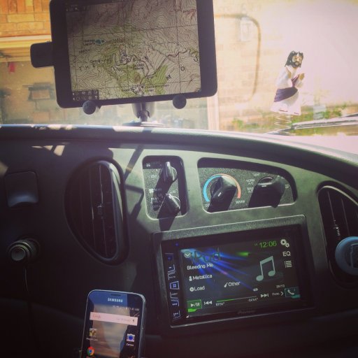
I use the BadElf GPS antenna (available for iWhatever and Android). I have the Garmin app and "Topo Maps." I download the high res USGS topo scans by the sections. You can set waypoints, etc.

image.jpg
 

WUzombies

Rank V
Launch Member
Supporter

Advocate II

2,261
Central Texas
Member #

0703

  • Like
Reactions: david.lemke

TxTerra

Rank V
Founder 500
Launch Member

Influencer II

2,853
prosper, tx
Member #

#0335

im using backcountry navigator on a galaxy s5 (android). its great! it has a crap ton of features and a pretty good learning curve to go with it, but its def worth it.

you have a large selection of maps to choose from (some are free, and some you have to have a annual subscription to download). You can also record your gps track and upload it as a gpx file to view on another tablet, computer, phone, etc
 

Overland-Indiana

Overland Bound - Midwest Regional Ambassador
Launch Member

Influencer II

3,316
Kokomo
Member #

0750

I need to get some form of GPS (other than my Garmin lol) I just don't visit very remote locations to really make use of it. Most places a simple compass can get me out of where I am, if i get lost. I do keep paper maps of places i visit often though, they stay in a small plastic tote in the Jeep.
 

KD7WCD

Rank VI
Founder 500
Member
Investor

Influencer I

3,002
Tempe, AZ, USA
First Name
Jayson
Last Name
Adamsen
Member #

399

Ham/GMRS Callsign
KD7WCD
I need to get some form of GPS (other than my Garmin lol) I just don't visit very remote locations to really make use of it. Most places a simple compass can get me out of where I am, if i get lost. I do keep paper maps of places i visit often though, they stay in a small plastic tote in the Jeep.
I love paper maps. I use to make my own with "Topo" and a large format printer I have. But more and more I find myself just using Backcountry Navigator on my Android tablet. As long as you think ahead and download the areas you will be in before you get out or Cell or WiFi range. It takes about a tenth of the time than printing a map and you can add waypoints and tracks in real time.

Put I do still love the fell and touch of a real paper map.
 
  • Like
Reactions: Overland-Indiana

Overland-Indiana

Overland Bound - Midwest Regional Ambassador
Launch Member

Influencer II

3,316
Kokomo
Member #

0750

I love paper maps. I use to make my own with "Topo" and a large format printer I have. But more and more I find myself just using Backcountry Navigator on my Android tablet. As long as you think ahead and download the areas you will be in before you get out or Cell or WiFi range. It takes about a tenth of the time than printing a map and you can add waypoints and tracks in real time.

Put I do still love the fell and touch of a real paper map.
Maybe i need to give Backcountry Navigator a try.
 

KD7WCD

Rank VI
Founder 500
Member
Investor

Influencer I

3,002
Tempe, AZ, USA
First Name
Jayson
Last Name
Adamsen
Member #

399

Ham/GMRS Callsign
KD7WCD
Maybe i need to give Backcountry Navigator a try.
They did have a free demo version if you want to try it out. I think is it is pretty sweet and user friendly if you have played around with similar software. They do have a pretty good looking help section online. On one thing I do find frustrating about it is the file management. Moving files for different trips and versions of trips back and forth seems cumbersome but I think that has as much to do with the Android platform as this software.