Gauging interest in El Camino del Diablo (AZ, 3 day)

  • HTML tutorial

Barclay

Local Expert Southern CA
Launch Member
Member

Influencer I

3,325
Los Angeles
Member #

10140

Ham/GMRS Callsign
K6BDO
I'm investigating a 3 day El Camino del Diablo trip this fall (Oct/Nov); I haven't run this trail since about '95 (in a CJ5!). I'd like to gauge interest in a <10 rig trip. (10+ rigs require a special permit.)

- It's an "easy" trail, but 4x4 is required for some of the sand washes depending on conditions. The hardest pieces range from deep silty sand to muddy pits based on recent weather. (Mud is rare unless there was a recent monsoon.)
- This trail comes extremely close to the US/Mexican border; border patrol encounters are entirely probable. If you have issues with that, I recommend not attending.
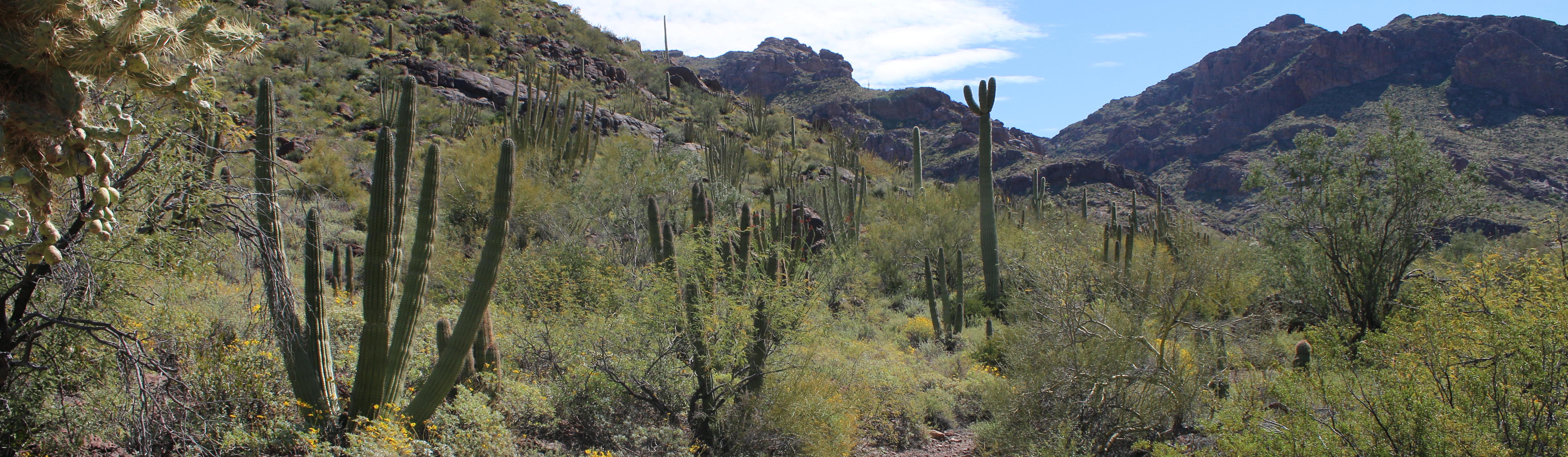
- That said, it's extremely isolated (and beautiful). Self sufficiency and pack-in/pack-out required. My recommendation is 1 gal of water/person/day, minimum. Assume no facilities, and no cell.
- I'm not asking for commits yet, but eventually I will have to get a hard yes/no. There's a lot of logistics involved around permitting with the Yuma and Ajo offices, including a portion that goes through a live-fire air force range. Everyone 18+ must have a permit, or be accompanied by an adult. I still have a bit of research to see if Cabeza Prieta requires permits now, and what the current details are, but in any case, there really won't be the possibility of a "surprise late arrival," because if you're not permitted on the range, you're assumed to be a target for the air force. Best of luck with that. :)

Let me know if the Oct/Nov timeframe is possible for you (I realize that's pretty broad, I'll narrow it down as soon as I can), and I'll see if I can get this thing going.

-B
 

Barclay

Local Expert Southern CA
Launch Member
Member

Influencer I

3,325
Los Angeles
Member #

10140

Ham/GMRS Callsign
K6BDO
Ok, did a bit more research. Some good news:
- It looks like you can do permitting online now, as opposed to having to physically stop at the Marine Corp base in Yuma, and then the Air Force base in Ajo, like in the bad old days. (Whoo!) Attendees will have to create an account at Home - Luke AFB iSportsman Service - iSportsman, watch a safety video, and apply for a permit (all of which is free). This permit should cover all the lands the trail goes through (at least, the east/west portion I plan on, technically the historical trail continues north past Yuma.)
- We will have to check in online before departing Ajo.
- That said, permits are mid-year to mid-year, which means if you get one now, it will expire before the fall. I'll wait to post an RP until after the mid year (and once I have a better handle on dates.) Getting the permit will be a hard requirement.
- The expected route would be E to W, meaning meet in Ajo, AZ, and end at Yuma, AZ.

-B
 

mep1811

Rank IV

Pathfinder I

1,212
El Paso, Texas
First Name
Michael
Last Name
Perez
Just got back from a trip in Feb. Permitting is super easy now. We had great weather and only one flat tire. Five trucks is about max to fit in the campsites along the route. if you don't have Mexican cell service in your cell phone, it is best to shut off your phone or risk a high phone bill.

Attached is a link to some articles I've written for different magazines. There are two Camino del Diablo articles . The Devils Highway and Highway Men : An Overland Adventure along the Devils Highway. I hope you enjoy them and the others.


Last edited:

Barclay

Local Expert Southern CA
Launch Member
Member

Influencer I

3,325
Los Angeles
Member #

10140

Ham/GMRS Callsign
K6BDO
Just got back from a trip in Feb. Permitting is super easy now. We had great weather and only one flat tire. Five trucks is about max to fit in the campsites along the route. if you don't have Mexican cell service in your cell phone, it is best to shut off your phone or risk a high phone bill.

Attached is a link to some articles I've written for different magazines. There are two Camino del Diablo articles . The Devils Highway and Highway Men : An Overland Adventure along the Devils Highway. I hope you enjoy them and the others.


Awesome, thanks for the the update! Given that it's been ~25 years since I've been there, would you be willing to pass along some GPS coordinates for some of the larger camping spots? IIRC there weren't too many, and you're not supposed to camp very far off the road.
 

mep1811

Rank IV

Pathfinder I

1,212
El Paso, Texas
First Name
Michael
Last Name
Perez
Thanks . Here is a segment that did not make the latest article.


Planning your Adventure

Getting there:


Depending on your location, the Camino del Diablo can be run East to West or vice versa. The starting and ending points depending on your direction, is Ajo, Arizona and Yuma, Arizona.

While Yuma is a good-sized city, Ajo is a small town with limited amenities so one should plan supplies accordingly.

Upon completing the Camino, it is only a matter of jumping on either Interstate 10 or Interstate 8 to head home.

Preparation:

As with any off-road trip, performing a map recon is essential in obtaining a 30,000-foot view of the trip. In performing this recon, you see that this trip traverses the Organ Pipe Cactus National Monument, Cabeza Prieta National Wildlife Refuge and Barry M. Goldwater Air Force Range. You will need to plan ahead and get permits.

If you are in a group of five or more, you will need a group permit. If you are towing trailers, the wildlife refuge will need pictures. It is always best to call ahead and find out exactly what they require for your specific trip. The number for the Cabeza National Wildlife Refuge is (520)-387-6483.

There are numerous online sources of information about the Camino you can access. (See resources section.)

Cell phone coverage:

The Camino is remote and there is virtually no cellular service. Proximity to the Mexican border does result in cell phones registering on Mexican towers (TELCEL). If you do not have Mexican cell service on your cellular plan you could incur hefty expenses operating on TELCEL. It would be best to either shut off your phone or put it on airplane mode until you reach either end.

Gear:

There are no services on the Camino. Bring recovery gear, spare tire, first aid kits, everything you need off-road.

Border Patrol, federal wildlife officers and range wardens patrol the Camino but their job is not to provide road service to the unprepared. They will call help for you, and that help will be costly.

Bring clothing for all types of weather. In the desert, the weather can change drastically in a matter in hours. Bring cold weather gear and rain gear.

Due to pervasive illegal immigration activity, travelers on the Camino should have a plan for such encounters. Border Patrol agents will ask if you are armed and every agent, I’ve spoken to has always affirmed that decision.

Firearms:

Those possessing, transporting, or carrying firearms on national wildlife refuges must comply with all federal, state and local laws.

Arizona is a constitutional carry state. All citizens, 21 or over, who can legally own a firearm, can carry a handgun openly or concealed without a permit or license. This applies to both residents of the state and those just visiting. No target shooting allowed.

There is no firewood along the Camino so you are encouraged to bring your firewood. Please only use existing fire rings.

In addition to paper copies of your permits, a picture of the permits on your phone is a good idea if the paper copy disappears.

Do not completely trust a GPS. There are maps available of the Camino area that will offer a better understanding of the trails and surrounding areas.

Weather:

Weather in the desert is unpredictable. Always plan for both warm and cold weather. It also rains in the desert and when it rains there is the danger of the road flooding and flash floods in arroyos.

You can check weather conditions by checking the weather in Ajo and Yuma, AZ. That will give you a good idea of weather conditions on the east and west sides of the Camino area.

Travel in the summer is not recommended due to the triple digit temperatures. Late fall to late spring are the best times to travel.


Resources:


http://www.cohp.org/personal/images/Desert_Peaks_Thanksgiving_2014/documents/CPNWR_Visitor_Regulations.pdf
 

er waddell

Rank VI
Member
Investor

Influencer I

3,815
Bay Colony Street, Las Vegas, Nevada 89131, United States
First Name
Earl
Last Name
Waddell
Member #

27544

Ham/GMRS Callsign
KJ7GYU
Service Branch
United States Army
I am interested in this!!
Which 3 days of the week would this occur? I am off Friday, Saturday, and Sunday. Trying to decide how much vacation time to save.
Read, understand, and comply with ALL gear requirements mentioned by mep1811.
 
  • Like
Reactions: Jim (Placerville)

oneleglance

Rank V

Contributor II

1,453
Phoenix, AZ, USA
First Name
LANCE
Last Name
BLAIR
Ham/GMRS Callsign
KE7NKP
I have been running the Camino since 2007 and it is only 1/2 the fun it used to be since the border wall construction resulted in some dirt super highways as you get close to Tule Well.
The part from Ajo to mid way is still the remote feel and you will love it.
I would highly recommend Christmas Pass and some of the Northern tracks to get extra play time as you can now run the entire thing in 1 day.
I like to camp at Bates Well, Tule Well and then pick a random other area....make sure you climb Tinajas Altas if you are reasonably fit as the higher natural water depressions (tanks) are really cool.
There are graves and other cool bits of history along the way but make sure NOT to touch at metal objects as there are live fire exercises.
Oh and lastly please take an American Flag for the Boy Scout Monument behind the adobe cabin at Tule Well.
 

1Louder

Rank VI
Launch Member

Member II

4,187
AZ
First Name
Chris
Last Name
K
Member #

1437

Ham/GMRS Callsign
K1LDR
I have been running the Camino since 2007 and it is only 1/2 the fun it used to be since the border wall construction resulted in some dirt super highways as you get close to Tule Well.
The part from Ajo to mid way is still the remote feel and you will love it.
I would highly recommend Christmas Pass and some of the Northern tracks to get extra play time as you can now run the entire thing in 1 day.
I like to camp at Bates Well, Tule Well and then pick a random other area....make sure you climb Tinajas Altas if you are reasonably fit as the higher natural water depressions (tanks) are really cool.
There are graves and other cool bits of history along the way but make sure NOT to touch at metal objects as there are live fire exercises.
Oh and lastly please take an American Flag for the Boy Scout Monument behind the adobe cabin at Tule Well.
Still scenic but pretty much a wide-open dirt road that a Civic could navigate. It is a real shame. I agree with the northern routes that are no a part of the official trail but are in the permitted areas.
 
  • Like
Reactions: Jim (Placerville)

Barclay

Local Expert Southern CA
Launch Member
Member

Influencer I

3,325
Los Angeles
Member #

10140

Ham/GMRS Callsign
K6BDO
So far the way this year is turning out, I may not end up with the time off to do it this year. Will update if that changes.