jerdog53
Rank V

Enthusiast III
I reason I got the Garmin Montana was because I could switch it between the bike and the Rover using completely different modes.
Enthusiast III
Is this for Apple only? Can't find in play store & nothing on Google search.You can also use an app called "rammblr" it uses Google maps and tracks your movement so no need to download trails.
Just a cheaper alternative to buying a gps.
Sent from my SAMSUNG-SM-N920A using OB Talk mobile app
Autocorrect threw in a second "n". Ramblr is in the play store, not sure about what apple has.Is this for Apple only? Can't find in play store & nothing on Google search.
Sent from my LG-D851 using OB Talk mobile app

Enthusiast III


Enthusiast III
I didn't realize all the options available to me. I was happy with Gaia GPS and Google Maps offline. Good info here
Enthusiast III

Member II
2301
The best offline map is 'Off-Road Trail Guide' it's similar to Gaia with better features. Beta testing now.
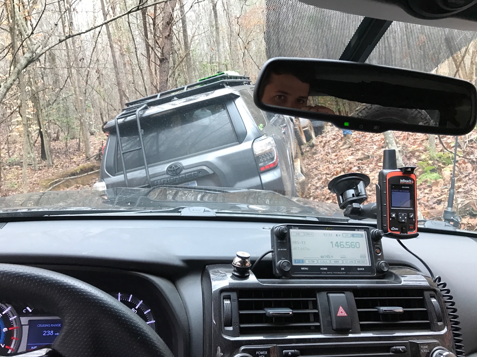
For those using InReach at GPS, after linking via BluTooth, is there any additional step? I'd like to put it in airplane mode and use the offline map with just Bluetooth. Haven't been able to test yet.
Sent from my iPhone using OB Talk
Great to know! I have a delorme and had NO clue it could do that! Thank you for the info!The Delorme (now Garmin) inReach Explorer with an iPhone 6 Plus, rocks! Just download all maps to your phone or tablet and you are good just about anywhere with the Earthmate, or GAIA apps. Of course the added piece of mind that you have a two way communication SOS beacon device that works via the Iridium satellite system is just the icing on the cake! Just got it setup so I haven't tried the tracking feature yet. What's really cool is it allows you to post your GPS location to a webpage or social media where your friends can follow along with you while out on the trail.
View attachment 16905
Also going to be replacing the Arkon phone holder seen in the above pic with one of these that is designed to specifically fit the inReach SE/Explorer models available at B&H for $59 (no tax, free expedited shipping).
****UPDATE and product name correction 03/14/17***
I finally got around to purchasing and installing the new Delorme/RAM (not Arkon) mount from B&H. And like most RAM mount products I've purchased in the past, this mount is extremely well built, and will hold your device firmly in any position for years of use. You have the choice to use the cup holder attachment/mount, or you can just screw your RAM ball base mount to fit your desired surface or application. I happen to already own a ProClip mount, so I just screwed the RAM base ball mount direct onto it and I must say I'm very happy with the results. A bonus is that you can just leave the device plugged in and setup your InReach to power on and off in sync with an external power source (aka your 12v accessory receptacle).


Trail Blazer I
Wondering what everyone is running as far as navigation with tracking. What do you recommend & why?
Sent from my LG-D851 using OB Talk mobile app
Enthusiast III

Enthusiast I

Explorer I
2951
I dont know how many of us overland on a motorcycle too, but I have the Garmin Zumo 665. Weather proof to be in the driving rain, and works with gloves. Also has satellite Weather and Traffic. Bought this after dodging the tornado that hit Joplin, MO stopping every 50 miles or so to look at the radar on the phone. For the tablet I have a GlobalSat ND-105C allows GPS on non GPS devices or can be used to supplement.


