• Guest, we will be conducting site maintenance this week and some downtime is expected. At this time Rally Point and the Member Map will also become an app-only feature for long-term security and stability. A few days after this maintenance, a major upgrade revision to the forum site will occur.
  • HTML tutorial

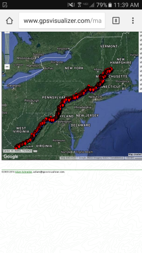
Crazy Appalachia Idea.

Litedrizzle

Rank 0

Traveler I

I'd be willing to help with Wv don't know everything but know a few people who could tell me what we need to know and in my opinion I'd prefer south to north if we just take the interstate down and trail ride all the way up

Sent from my SM-N915V using OB Talk mobile app
 

Clymber

Rank 0

Traveler I

I assume you would like to keep as close as possible to the AT. Do you want to stay on non paved roads or trails. In NH/VT they are either Class 6 NH or class 4 VT. Do you mind plain dirt roads
 

First State Overland

Rank V
Launch Member

Influencer II

It would be awesome if we picked a route where small offroad trailers could go too, but I'd still be up for it without the trailer.
 

MA_Trooper

Rank VI
Launch Member

Influencer II

It's going to be tough to know 100% whether a trailer can make it or not because there will likely be some going off book moments. I want to have a solid route planned but I also want to leave some room for general exploring and route finding in the field. That said, we won't know for sure until we have some semblance of a route. Soon. I want to hang with some folks and get a couple conference calls going with locals to hash stuff out.
 

Scout

Rank V
Launch Member

Pathfinder I

I'm liking this. Sounds like it'll give me plenty of time to get my truck set up. New wheels and tires due in a week.
 

MA_Trooper

Rank VI
Launch Member

Influencer II

Ok. I want to start having some conversations with folks soon. I know a few of you have mentioned wanting to help. I would like to find a way to hit all the states in the east on this run, understanding that a couple may just not be possible due to proximity to the mountains. I still want to try. Anyhow, those of you who live or have a good deal of experience with the trails in the Appalachian vicinity, I want you folks to get in touch with me or make yourselves know. I saw one for West Virginia and Virginia and I believe there was someone who mentioned having some experience in VT. That's a great start. I will look back through this thread and get in touch with folks who already expressed ability to help. If you have trail info, camp info or just general knowledge of some of the areas please let me know. If you know of some good resources with up to date maps and info on trails and soft roads let me know. This thing won't happen without some support from all of you. Thanks for your help so far and thanks for the help still to come.
 

Chris W

Rank IV
Launch Member

Influencer II

I'd be more than happy to help plan out the section through CT. There isn't any legal off-roading in the state, but we can try to stay off pavement as much as possible through the NW corner along the AT.
 

04land

Rank V
Launch Member

Enthusiast III

I'm trying to get over to Walpack NJ where the Appalachian runs through a small part of New Jersey. As many of you probably know this part was also done by Mid-Atlantic Expeditions and mapped out.
 

TerryD

Rank VI
Launch Member

Member III

Are you looking to just put a straight line up the map and try to stick to dirt and trails along the way our are you going to snake along where the trails are? That'll make a difference in where you enter and exit states and what areas you pass through I'd think.
 

MA_Trooper

Rank VI
Launch Member

Influencer II

A little of both. It would be nice to hit some trails and also swing through some historic sites along the way. But I want to try to stick in the shadows of the mountain range, so to speak.
 

ed060784

Rank V
Founder 500
Launch Member

Enthusiast III

Hey Chris I own NE-OVEX inc (New England Overland Expeditions ) and I have very good coverage with detailed tracks of the New England area from ME , NH, Some VT ,MA and a lil bit in CT, i also have the Trans NJ trip
I live in NE MA and if you need any help feel free to reach me via FB or email


Sent from my iPhone using Tapatalk
 

MA_Trooper

Rank VI
Launch Member

Influencer II

Hey Chris I own NE-OVEX inc (New England Overland Expeditions ) and I have very good coverage with detailed tracks of the New England area from ME , NH, Some VT ,MA and a lil bit in CT, i also have the Trans NJ trip
I live in NE MA and if you need any help feel free to reach me via FB or email


Sent from my iPhone using Tapatalk
Thanks. I will probably reach out to you soon.
 

rixham

Rank V
Launch Member

Off-Road Ranger I

I like this idea. If you need any help with logistics, let me know.

-r
 

Infidel439

Rank I

Enthusiast I

That would be awesome
Chris, I'm a new member and have not been out on the trails yet. But as far as a route through Virginia I immediately thought of the Tail of the Dragon at Deals Gap, 318 turns in 11 miles! It's a big to do in Virginia especially with motorcycles and sports cars, so why not add to it! Since I'm so new I can't post links, so type in your browser tailofthedragon.com. It starts in TN and NC working up the the Blue Ridge Parkway. There's even an off the path hike that can be done to Crabtree Falls (water fall look out), again type roanokeoutside.com hiking water falls.
 

Bjorn44

Rank V
Launch Member

Off-Road Ranger II

Im definitely following this thread!!!! I know of a few trails in Virginia.

Sent from my SM-G920P using Tapatalk
 

Al_Maryland

Rank 0

Contributor II

Interested. I will be following this thread. Hopefully your trip in 2018 will be late summer as I will be working out of state early in the year.
 

dziner

Rank V
Launch Member

Pathfinder I

I'm in Harrisburg, PA with a good bit of knowledge of what's here in central PA. Michaux State Forest is located in the southern portion of the Pennsylvania and offers some dirt roads from route 34, west and south into Maryland. A lot of our mountain ranges seem to run east/west, and as such a lot of the roads through our forests also run that direction.

Tuscarora State Forest offers some dirt roads with the help of several miles of pavement to go from Newville, PA area north towards Lewistown, PA. Then you have Rothrock and Bald Eagle State Forest. Bald Eagle State Forest will probably get you further north and east. Then maybe transfer into Tiadaghton State Forest, Sprout State Forest, and Susquahannock State Forest. I've never been in any of these, but they make up a majority of north central Pennsylvania.

I'd estimate traveling through Michaux, then getting into Tuscarora to Lewistown area would be a full day. Really not sure about the northern reaches.

Let me know if I can be of any help for the Pennsylvania section.
 
Top