A couple days exploring Cherokee, Pisgah and Nantahala Nat'l Forest
- Thread starter TerryD
- Start date
You are using an out of date browser. It may not display this or other websites correctly.
You should upgrade or use an alternative browser.
You should upgrade or use an alternative browser.
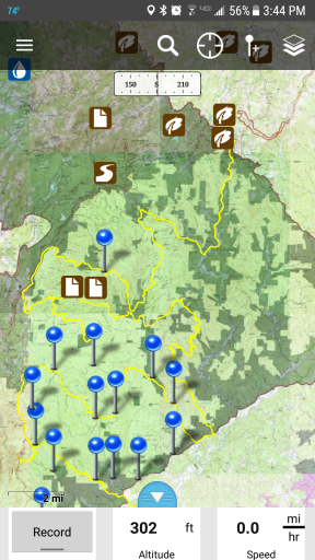
Here's about 150 miles of mostly forest service dirt and gravel. It starts in Blowing Rock in case you need to supply with some expensive tourist type stuff and winds around the area including Wilson Creek, Table Rock and Linville Gorge.
This is my first time of uploading a file so I hope it works.........
This is my first time of uploading a file so I hope it works.........
Attachments

Here's about 150 miles of mostly forest service dirt and gravel. It starts in Blowing Rock in case you need to supply with some expensive tourist type stuff and winds around the area including Wilson Creek, Table Rock and Linville Gorge.
This is my first time of uploading a file so I hope it works.........
Rock and roll!!! Worked great! Thanks much.
Attachments

Member III
Doh, thought I was replying to justjames. Hah. Is it a Gmaps link?
I thought that was a link to the map in google maps. Let me work on it some tonight. I'm going to be around the computer filling out some QSL cards and I'll try to get a link to it up. I had shared it somewhere (thought it was here) so people could access it to add routes to it or download it.
Member III
Try this @Trailex
Click on the little box with the arrow in the upper right corner of the map
When it comes up in drive, click "Open in Google My Maps" at the top of the page. (You may have to be signed into Google for this to work properly.)
Holy Smokes, the wonders of the incanet! Thx again
Member III
Here's about 150 miles of mostly forest service dirt and gravel. It starts in Blowing Rock in case you need to supply with some expensive tourist type stuff and winds around the area including Wilson Creek, Table Rock and Linville Gorge.
This is my first time of uploading a file so I hope it works.........
I added these tracks to my map! Some of it was already on there but we're gong to have to do several trips there in the future to check it all out. Thanks!
Your expanding GMap is great!I added these tracks to my map! Some of it was already on there but we're gong to have to do several trips there in the future to check it all out. Thanks!


Member III
Well, the trip is coming up soon. I upgraded my front coilovers and I'm doing a little shake down run this weekend with a group of other Xterras near Woodstock, Va.
Gonna start checking out gear and packing soon. Thanks for all the help with the maps and info on the area everyone!
Gonna start checking out gear and packing soon. Thanks for all the help with the maps and info on the area everyone!

Here's about 150 miles of mostly forest service dirt and gravel. It starts in Blowing Rock in case you need to supply with some expensive tourist type stuff and winds around the area including Wilson Creek, Table Rock and Linville Gorge.
This is my first time of uploading a file so I hope it works.........
Just imported the file into LocusPro. THANKS!
Had a few of these planned/routed out but not as one route.
Not sure what I did when I imported it though. It saved the route line with the details I gave it but it seems to have created a waypoint at every instance your device saved trip data.
LOL, now I have a route with a gagillion arrows on it.
Humm............. I can't remember if that was done on Gaia or Garmin. Either way, have fun!Just imported the file into LocusPro. THANKS!
Had a few of these planned/routed out but not as one route.
Not sure what I did when I imported it though. It saved the route line with the details I gave it but it seems to have created a waypoint at every instance your device saved trip data.
LOL, now I have a route with a gagillion arrows on it.
Try this @Trailex
Click on the little box with the arrow in the upper right corner of the map
When it comes up in drive, click "Open in Google My Maps" at the top of the page. (You may have to be signed into Google for this to work properly.)
@TerryD , very cool! My wife and I live in Knoxville, but are from Sylva and have family in Newland. We are circling back to the overland setup as our kid is finally old enough and this map helps set up a Knox to Newland to Sylva circuit for multiple trips! Thanks!

Contributor III
Here's about 150 miles of mostly forest service dirt and gravel. It starts in Blowing Rock in case you need to supply with some expensive tourist type stuff and winds around the area including Wilson Creek, Table Rock and Linville Gorge.
This is my first time of uploading a file so I hope it works.........
Thank you so much I am planning a large trip around March or April and this helps a lot how long is this and how long did it take you and where did you camp thanks for your help again
Try this @Trailex
Click on the little box with the arrow in the upper right corner of the map
When it comes up in drive, click "Open in Google My Maps" at the top of the page. (You may have to be signed into Google for this to work properly.)
WOW! This is exactly what I was looking for! My gf and I where planning a trip down there in October. Is there a way for me to have this map offline on a Iphone? I am technologically challenged.
Contributor III
WOW! This is exactly what I was looking for! My gf and I where planning a trip down there in October. Is there a way for me to have this map offline on a Iphone? I am technologically challenged.
Gaia gps allows you to down load
