
Love your Avatar! Nothing better than watching a good Dog work....or having fun.....Wrong country.
Windshield Pics...
- Thread starter BlackBear
- Start date
You are using an out of date browser. It may not display this or other websites correctly.
You should upgrade or use an alternative browser.
You should upgrade or use an alternative browser.


Advocate III
"There's a road, in Oklahoma
Straighter than a preacher
Longer than a memory
And it goes, forever onward
Been a good teacher
For a lot of country boys like me..."
~Steve Earle, Nowhere Road

I made this image years ago. I love it. Was just east of Boise City, Oklahoma on US 412 after a winter storm had laid down a thick sheet of ice over everything.
This stretch was about fifty miles of straight, thick, ice, like a skating rink. You got up to speed and didn't dare touch the brakes or turn the wheel.
---------------------------

Storm in the Borderlands during some gravel travel.
-------------------------------

Loaded up and rolling through the Dakotas.
---------------------------

After the storm in the borderlands.
.
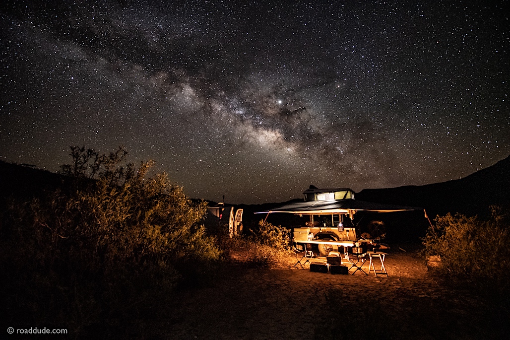
 roaddude.com
Straighter than a preacher
Longer than a memory
And it goes, forever onward
Been a good teacher
For a lot of country boys like me..."
~Steve Earle, Nowhere Road
I made this image years ago. I love it. Was just east of Boise City, Oklahoma on US 412 after a winter storm had laid down a thick sheet of ice over everything.
This stretch was about fifty miles of straight, thick, ice, like a skating rink. You got up to speed and didn't dare touch the brakes or turn the wheel.
---------------------------
Storm in the Borderlands during some gravel travel.
-------------------------------
Loaded up and rolling through the Dakotas.
---------------------------
After the storm in the borderlands.
.
Roaddude - On the Road In North America - ROADDUDE
Roaddude - Traveling Photographer/Writer/Artist On the Road In North America. Gear, reviews, people, places, and culture.
Last edited:
We went to OK when my Son was at Ft, Sill, I loved it, big sky, almost like being at sea, because you see to the horizon . But the funniest thing was Mt. Scott at 3,000 something as a mountain. Here , that's barely a foot hill....
Advocate III
We went to OK when my Son was at Ft, Sill, I loved it, big sky, almost like being at sea, because you see to the horizon . But the funniest thing was Mt. Scott at 3,000 something as a mountain. Here , that's barely a foot hill....
I know the Lawton and Duncan area quite well. There's an awesome and engaging museum in Duncan on the Chisholm Trail.
Yeah, when most of the terrain around is flatter'n hell, anything that sticks up a ways is noticeable. Top of Mt Scott is just under 3,000 feet but actually only sticks up from the surrounding landscape about 800 feet.
Yes, we went to the museum and the one on the Ft. Sill base and the graveyard there too, We also had one of those giant Hamburgers at that place by the nature reserve...

Enthusiast III
- 1,597
- First Name
- Bud
- Last Name
- McLaren
- Member #
18512
- Ham/GMRS Callsign
- KN6EBY
- Service Branch
- Firefighter/Paramedi

Enthusiast III
.JPG")


Member II


Enthusiast III


Enthusiast II
- 539
- First Name
- Cory
- Last Name
- Leicht
- Member #
20908
- Ham/GMRS Callsign
- GMRS WREZ615


Pathfinder III


Expedition Master III
View attachment 128412View attachment 128413View attachment 128414View attachment 128415View attachment 128416
Had some fun at tie rod today.
What area? for these photos. The Union Pacific usually date stamped all their access portals, at least those I have seen between LV south past Primm CA area, and some North towards the Utah border. If you go South where LV BLVD and the RR tracks parallel...aka, crosses the I-15, you can follow the tracks a little North, and find a old stone building that sits above the tracks. I wonder if it was a security point during WWII, like other areas had. Have you ever seen the gun emplacement bunkers built around the dam during that time also?
Last edited:


Enthusiast II
- 539
- First Name
- Cory
- Last Name
- Leicht
- Member #
20908
- Ham/GMRS Callsign
- GMRS WREZ615
What area? for these photos. The Union Pacific usually date stamped all their access portals, at least those I have seen between LV south past Primm CA area, and some North towards the Utah border. If you go South where LV BLVD and the RR tracks parallel...aka, crosses the I-15, you can follow the tracks a little North, and find a old stone building that sits above the tracks. I wonder if it was a security point during WWII, like other areas had. Have you ever seen the gun emplacement bunkers built around the dam during that time also?
So we took the old 15 hwy aka Las Vegas Blvd south from the M Resort and turned west on Sloan. Took Sloan for about 1-2 miles just before the mining company is (i think it’s a mining company) and then we tuned left into the desert and on a fairly maintained road. We came to the railroad tracks and we approached the tunnel. Latitude 35.9385 Longitude -115.2244 is about the location we went under the tracks.
Expedition Master III
So we took the old 15 hwy aka Las Vegas Blvd south from the M Resort and turned west on Sloan. Took Sloan for about 1-2 miles just before the mining company is (i think it’s a mining company) and then we tuned left into the desert and on a fairly maintained road. We came to the railroad tracks and we approached the tunnel. Latitude 35.9385 Longitude -115.2244 is about the location we went under the tracks.
I thought that might be the area. Saw what looked like..........
PS. .....A little history......
It is a Gypsum mine {Sloan NV} (strip mine), as are the other 2 in our area. The Big one in Blue Diamond (strip mine) off Hwy 160 west, and the other off Lake Mead Blvd (strip mine) on the other side of Sunrise Mountain near the Lake. The original Mine was done by tunneling. The old ballast line can be seen on Hwy 160 as it crosses near Buffalo Rd, and little parts of it not buried under new construction heading west. The original RR line went out thru what is now Rhodes ranch development. The tunnel entrances have mostly been blasted shut. This is where the recent LV OB member meetup was done just a few weeks ago. The Blue diamond mine used the Union Pacific RR line spur through the 60's and then started using trucks to transport finished wallboard when they switched to on premise manufacturing, and no longer shipped raw material by rail hopper car. The early tunnel mine used a spur that branched off to the mountain base, before the latter spur to Blue Diamond was built, and you can still see the building foundations in the area below the original mine . The building of the southern part of Rhodes Ranch obscured all traces of the original ballast spur line.
Where the OB meet & greet was held (Fort Apache area), there seems to be a dirt/gravel road bed. That is part of the original spur line, at the old mine site. It went up past the foundation footings and looped itself back around so hopper cars could be loaded by a gravity shoot/belt loader apparatus, and the engine did not have to use a "Y" to turn around on to be at the front of the 'consist' when heading back to the main line at Arden, NV (Rainbow Blvd/south of 160) near where the new Walmart was just put in.
Last edited:
Enthusiast III

Heading to an amazing beach... USAL Beach. Bring an ax or chainsaw, lots of trees.

Steward I
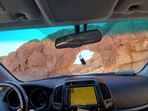
 The only tracks ahead of me were coyote tracks. Death Valley, 11/29/19.

