Wheeling trail to camping near Hetch Hetchy? (ish)

  • HTML tutorial

Drftsub

Rank V
Launch Member

Advocate I

1,653
Boulder Creek, CA
Member #

3397

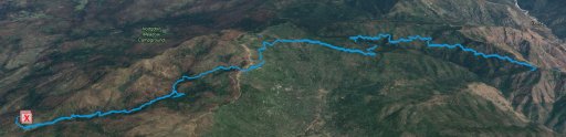
See the route we took in my post a few down from here.

So,
My wife is doing a backpacking trip w her friends coming up in a few weeks that I will not be joining (bad knees, no large hikes for me) where they will be doing just a quick 20 mile 1 night deal and I was going to try to find a nice trail to camping, ideally near some water in the area.

They are starting at Hetch Hetchy, but I can venture to the not too far area as I will be dropping her w the friends along their way and grabbing my buddy (his wife is also doing the hike) for this.

Any suggestions?

Thanks all!
 
Last edited:

Egan

Rank VI
Launch Member

Member III

3,084
93610
First Name
Egan
Last Name
Burgess
Member #

2639

You could try the route below and camp at Briceberg. It is a decent campground right on the Merced River. You might want to call ahead and make sure the route is open there is a lot of storm damage and downed trees in the area. If any of the trails are closed there are alternative routes. There are lots of interlinking forest service roads, fire roads and off road trails. Highway 120 is also closed between Hetch Hetchy and Yosemite Valley. In addition to the route below I have also added link to thread on the forums taht is a route in the general area. If you are interested let me know and I might be able to assist with a .kml file.

https://www.google.com/maps/dir/Briceburg,+CA+95345/37.8132121,-119.8846023/@37.713727,-119.9586893,12z/data=!4m39!4m38!1m35!1m1!1s0x8096c7d2e4e6237b:0x5ad8f07eb4a24d4!2m2!1d-119.964882!2d37.604504!3m4!1m2!1d-119.9675259!2d37.6058728!3s0x8096c7d4aa99a25f:0x6c72bb28a00f762c!3m4!1m2!1d-119.951725!2d37.6710031!3s0x8096c595bc9ca1d9:0x25a7991037105291!3m4!1m2!1d-119.9513966!2d37.6756998!3s0x8096c5bd86f079a7:0x16388c92b1397f2e!3m4!1m2!1d-119.9457228!2d37.6766806!3s0x8096c5a4f3b96ae5:0x90d69065f4faaca8!3m4!1m2!1d-119.8839176!2d37.7958716!3s0x8096db89e29b90c9:0x88fff0fe9d47a222!3m4!1m2!1d-119.8785524!2d37.8010836!3s0x8096db89e29b90c9:0x88fff0fe9d47a222!1m0!3e0

https://overlandbound.com/forums/threads/coulterville-to-curry-villiage-via-trumbull-peak-and-foresta.3421/
 

Egan

Rank VI
Launch Member

Member III

3,084
93610
First Name
Egan
Last Name
Burgess
Member #

2639

Here is the file. Like I said I would definitely call and check on closures also I would go on Cal Topo and use the USFS overlay and check for alternative routes in case there are closures or downed tree. If there are down tree you could bring a chainsaw or decent bow saw would do the trick. I have not been on any of these trails since early fall so that is why I am being cautious.
 

Attachments

Egan

Rank VI
Launch Member

Member III

3,084
93610
First Name
Egan
Last Name
Burgess
Member #

2639

Awesome. Thanks sir, I'll bring the saw along just in case


Sent from my iPhone using OB Talk
Let me know ehn you are going, maybe I can meet you somewhere along the trail.
 

Drftsub

Rank V
Launch Member

Advocate I

1,653
Boulder Creek, CA
Member #

3397

Heading up June 23 evening to drop the wife at Hetch Hetchy, will camp there w her crew for Friday night and then they / I will head out the next AM.

Trying to decide where the best camping spot would be, and if I should run down the trail sat, camp, then return Sunday to pick her up or just take main roads to the start and run one way .

I need to dig through GPS a bit and figure out what the best plan is.
 

Egan

Rank VI
Launch Member

Member III

3,084
93610
First Name
Egan
Last Name
Burgess
Member #

2639

The main road from the Hetch Hetchy area down into Yosemite Valley is closed. Briceberg is just 15 miles from the Yosemite Valley Entrance to the Park, so that route is not going to work. Unfortunately that is the shortest paved route. From Briceberg you could take 140 west to Mariposa and then 49 North to 120 East back to Hetch Hetchy. It is a nice drive but it would be about the same amount of time as just taking the off road route. If you just wanted to explore the off road area on Saturday and camp closer to Hetch Hetchy their are many camp grounds a little closer to Hetch Hetchy. I added a couple links below.

https://www.fs.usda.gov/recarea/stanislaus/recreation/camping-cabins/recarea/?recid=14927&actid=29
https://www.fs.usda.gov/recarea/stanislaus/recreation/camping-cabins/recarea/?recid=14939&actid=29
https://www.google.com/maps/place/Dimond+O/@37.8562922,-119.8778918,13.35z/data=!4m5!3m4!1s0x8096dc1f27abd4f5:0x1938953825b2b87f!8m2!3d37.8634139!4d-119.8695248
 

Drftsub

Rank V
Launch Member

Advocate I

1,653
Boulder Creek, CA
Member #

3397

Thanks again for the info!

I have no problem spending a bunch of time on dirt, and would prefer it honestly. So it seems the best plan is to head down the trails, and then back up on Sunday. to pick her up. Is there any allowed unimproved camping in the area you are aware of?

Thanks!
 

Egan

Rank VI
Launch Member

Member III

3,084
93610
First Name
Egan
Last Name
Burgess
Member #

2639

You should be able to camp in most many in the area, it is National Forest land.
 

Egan

Rank VI
Launch Member

Member III

3,084
93610
First Name
Egan
Last Name
Burgess
Member #

2639

I hope you have good time.
 

Drftsub

Rank V
Launch Member

Advocate I

1,653
Boulder Creek, CA
Member #

3397

HFR to TP.JPG

So, just in case anyone is watching this. We did in fact find many road closures so here is the route we took. It was great, but getting down to the Merced river / Briceburg was impossible from 5 corners. Many roads have closures right now due to washouts etc. The trail to Trumbull Peak looked like it had been quite a while since someone had traveled it and required quite a bit of trail clearing for access. My Tacoma definitely felt very big for the trail in many places. For any others venturing out there, bring a chainsaw (I am very glad I had mine with me) but the views and payoff are great. Overall we ended up finding a spot off of Hardin Flat Rd. that we could wheel back into and found a good creek with granite base to camp off of for Saturday night.

Overall it was a great trip, thanks for the help with the route @Egan !
Trumbull Peak Top.jpg
Trumbull Peak Trip 2.jpg
Trumbull Peak Trip.jpg
 

Attachments

Egan

Rank VI
Launch Member

Member III

3,084
93610
First Name
Egan
Last Name
Burgess
Member #

2639

I am glad to hear you had a good time. Too bad you could not get to the river, The views heading down to Briceburg are really beautiful. The last time I went to Trumbull Peak I was in my Excursion and it was tight but i did not have to clear the trail and that was in October. I knew the winter weather was going to make it more difficult.