Western US - Full Circle

  • HTML tutorial

jdunk

Rank VI
Founder 500
Member
Investor

Pathfinder II

4,387
King County, Washington, United States
First Name
Josh
Last Name
Duncan
Member #

0446

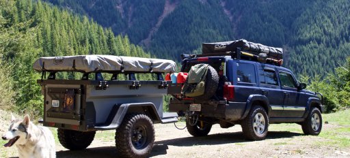
For the vast majority of people that don’t follow me on YouTube, you probably didn’t see that I’m working on a trip around the west of the United States in late September, early October.

There are a few places on my list that I know I’m going to stop at. Otherwise, I really don’t have any set route.

The key locations are going to be Hollister California, the Fall Overland Bound Rally, Green Valley Arizona, and Dallas Texas.

I think I am going to have around 3 weeks, possibly a little more for this trip. I expect that is going to make exploration a little difficult, but I imagine that where there is a will…

My plan is to cross through 4 different Overland Bound regions and 9 states and try to get a little taste as to what the areas are like.

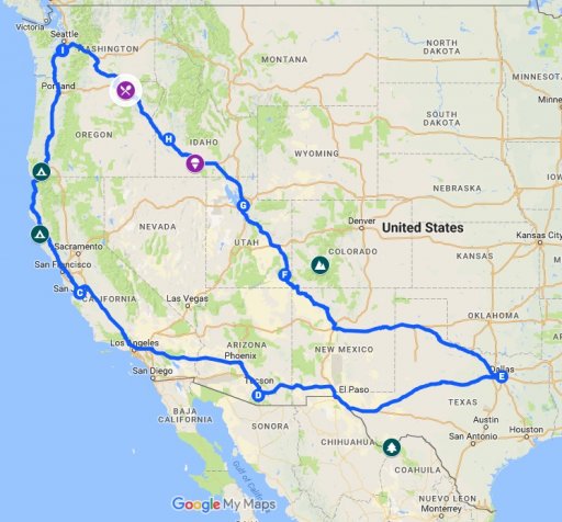
I’m going to keep track of suggestions and try to keep an updated approximation of my “planned” route. ( Google Map )

I would love to set up some meets and camps with local Overland Bound members along the way!

Any recommendations on routes, places to eat, places to camp would be amazing. The goal will be to set up Rally Points along the way based on timing, and input from people on the trip. So please, let me know what’s out there

I look forward to exploring more of the United States, and meeting the amazing people that live there!

IMG_4135 (1).jpg

map.jpeg
 
Last edited:

Steve

lost again...
Founder 500
Launch Member

Traveler III

4,312
Lorain County, OH, USA
First Name
Steve
Last Name
None
Member #

202

I'm looking forward to seeing the final route and stops! Who knows, we may cross paths again, depending on daughter's travel plans back to Seattle.

A couple suggestions: For that long slog on I-84 in SW Idaho, take the scenic bypass on US 30 between Bliss and Twin Falls. The Thousand Springs area is amazing, and Hagerman has an interesting fossil museum and wildlife area. A good spot for a lunch stop. But don't eat too much! Cloverleaf Creamery in Buhl has some of the best ice cream I've ever had. And pick up some chocolate milk for later. You'll thank me!

But instead of starting in Bliss, get off at the exit further south for Tuttle/Rt E 2350 S. Just a minute or two off the interstate is Malad Gorge State Park. Our first visit was going to be a short lunch break, but we ended up spending the afternoon exploring. Really a cool hidden gem!

If you end up in Pendleton at dinner time, I highly recommend The Prodigal Son Brewery and Pub. Good food, and atmosphere, and tasty beverages. We've stopped three times now!


Hmmm, eating and drinking seems to be a theme in my suggestions. :)
 
  • Like
Reactions: Quicksilver

jdunk

Rank VI
Founder 500
Member
Investor

Pathfinder II

4,387
King County, Washington, United States
First Name
Josh
Last Name
Duncan
Member #

0446

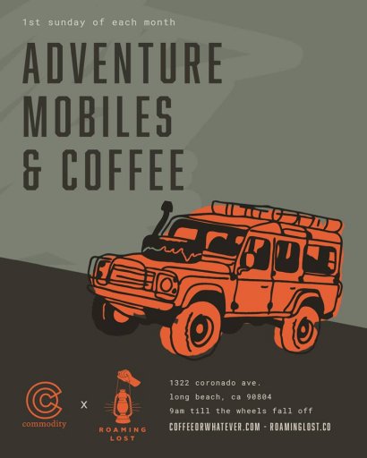
If for some crazy reason you're in LA area 1st Sunday of the month we have this lil get together...View attachment 57079
Noted! I will have to see how it works out with the Fall Rally.

I'm looking forward to seeing the final route and stops! Who knows, we may cross paths again, depending on daughter's travel plans back to Seattle.

A couple suggestions: For that long slog on I-84 in SW Idaho, take the scenic bypass on US 30 between Bliss and Twin Falls. The Thousand Springs area is amazing, and Hagerman has an interesting fossil museum and wildlife area. A good spot for a lunch stop. But don't eat too much! Cloverleaf Creamery in Buhl has some of the best ice cream I've ever had. And pick up some chocolate milk for later. You'll thank me!

But instead of starting in Bliss, get off at the exit further south for Tuttle/Rt E 2350 S. Just a minute or two off the interstate is Malad Gorge State Park. Our first visit was going to be a short lunch break, but we ended up spending the afternoon exploring. Really a cool hidden gem!

If you end up in Pendleton at dinner time, I highly recommend The Prodigal Son Brewery and Pub. Good food, and atmosphere, and tasty beverages. We've stopped three times now!


Hmmm, eating and drinking seems to be a theme in my suggestions. :)
Putting them on the map now!
 

WheelMe

Rank V
Launch Member

Enthusiast III

1,473
Aptos, California
First Name
Patrick
Last Name
Hung
Member #

9818

I live about 45 minutes from Hollister, CA, and highly recommend the Hollister SVRA for your visit; however, you may need to unhitch your trailer for most of the trails - lots of tight turns with trees and branches.

If you're spending at least a week in California, I'd also recommend that you head north to the Mendocino County coast, specifically camp on Usal Beach, continue north next day along the "Lost Coast" trails, and finally head back inland to camp at/near Humboldt Redwoods State Park. These trails are mostly easly-dirt, trailer-friendly, and away from the crowds, so good times (I camped for three nights on this run, taking it pretty easy).
 

jdunk

Rank VI
Founder 500
Member
Investor

Pathfinder II

4,387
King County, Washington, United States
First Name
Josh
Last Name
Duncan
Member #

0446

I live about 45 minutes from Hollister, CA, and highly recommend the Hollister SVRA for your visit; however, you may need to unhitch your trailer for most of the trails - lots of tight turns with trees and branches.

If you're spending at least a week in California, I'd also recommend that you head north to the Mendocino County coast, specifically camp on Usal Beach, continue north next day along the "Lost Coast" trails, and finally head back inland to camp at/near Humboldt Redwoods State Park. These trails are mostly easly-dirt, trailer-friendly, and away from the crowds, so good times (I camped for three nights on this run, taking it pretty easy).
Thanks for the info. I've added Usal Beach and Humboldt Redwoods State Park to my planning map. Hollister Hills was already on the map, as I have family in the area, and am trying to combine visits and exploration as part of this trip.

I'm very interested in Usal Beach. Are there any specific areas that you can actually camp on the coast?
 

WheelMe

Rank V
Launch Member

Enthusiast III

1,473
Aptos, California
First Name
Patrick
Last Name
Hung
Member #

9818

One can camp directly on the beach (at Usal Beach), or in the brushes just inside of the sand. For disbursed camping further north and along the trail, call the visitor center that I described in my writeup below in a different thread:

https://www.overlandbound.com/forums/threads/1st-overland-trail.14492/#post-218504

Scroll up in this same thread and you'll see some photos of Usal Beach and ensuing trails.

I just noticed that you're based in Washington... I supposed that you'll be driving north -> south? In that case you'll hit the Humboldt State Park first (right by Hwy. 101), and continuing west from there toward the tiny town of Honeydew, then south to Shelter Cove, and finally Usal Beach.
 
  • Like
Reactions: Dana Ramos

jdunk

Rank VI
Founder 500
Member
Investor

Pathfinder II

4,387
King County, Washington, United States
First Name
Josh
Last Name
Duncan
Member #

0446

Laud

Rank VI
Launch Member

Influencer I

3,145
Southeast Arlington TX
First Name
Laud
Last Name
Maroney
Member #

7010

Ham/GMRS Callsign
-KG5QHC-
Service Branch
Air Force and Army
I may have an option or three for ya in TEXAS, depending on how much time you have.
I have to recommend anything in the Big Bend Region...NP, SP, WMA. I am not a Gulf beach guy, so I can't speak for PINS.
We just completed circumnavigating the State. I've got a large selection of backroads and campsites if you need to kill some time and not slay Interstates.
 
  • Like
Reactions: Eric Neal

jdunk

Rank VI
Founder 500
Member
Investor

Pathfinder II

4,387
King County, Washington, United States
First Name
Josh
Last Name
Duncan
Member #

0446

I may have an option or three for ya in TEXAS, depending on how much time you have.
I have to recommend anything in the Big Bend Region...NP, SP, WMA. I am not a Gulf beach guy, so I can't speak for PINS.
We just completed circumnavigating the State. I've got a large selection of backroads and campsites if you need to kill some time and not slay Interstates.
I would love anything you have! Big Bend is already on the list. I expect that I'm going to be mostly in western Texas for this trip.

Once I start getting good information on recommendations for places to visit and stay, I'm going to start adjusting the routes and try to figure out some timelines.

I've added a screen grab of the google map I'm using to plan. It only has a basic route right now, but I expect it to change.
 

brien

Sonoran Space Program
Staff member
Moderator
Member

Off-Road Ranger I

3,402
Tucson, AZ
First Name
Brien
Last Name
Wankel
Member #

3553

Ham/GMRS Callsign
K7XPO
I'm glad to see you're including Baja Arizona on your trip. So many people come through the state but don't ever seem to head south of Phoenix. We have a lot of really cool stuff down here (I'm based out of Tucson) and I'd be happy to meet up, join you for a few days, or just pass on coordinates and routes. My family and I love exploring the borderlands and the sky islands and can definitely give points of interest and good camp spots. Here's a little writeup I did a while back on the borderlands in a different thread:

I explore south and east of Tucson quite a bit and can share some GPS tracks if you like. From SR-86 out of Why,AZ you can take 286 South toward Sasabe, AZ, then east on Arivaca Sasabe Rd and take it all the way to Arivaca, AZ. Stop at Arivaca Mercantile for resupply of fuel and groceries (NOTE they are only open 7AM-7PM M-F, 8AM-6PM Sun). From Arivaca you can head south out of town on S 5th Ave, then about a 1/2 mile south of town, turn east on to Ruby Rd. Just stay on Ruby Road through all it's twists it will eventually turn into a dirt road a mile or so before leading you into the Coronado National Forest. Once in the forest there are dispersed campsites to be found everywhere.

If you want to experience a bit of history, I recommend making a stop at the Ruby, AZ ghost town. follow the very small sign to turn south off of Ruby Road onto the property, there is a caretaker there that will ask for $10-12 per adult for access and then provide you with a map of the town which you are free to self-explore as much as you want. (http://rubyaz.com/) For an extra $8/night you can camp there, although you still need to be fully self-sufficient. No water is provided, but there are usable/stocked outhouses around the town.

Continue east on Ruby Rd, you'll pass more dispersed campsites and side-trails, eventually you will come to Peña Blanca Lake, there are a few drive-up campsites there, not sure how busy they get. The campsites and picnic areas around the lake have pit toilets available.

Continue east on Ruby Rd a bit more and you'll come to I-19. north to Tucson, south to Nogales. Nogales is the best/closest place to resupply if needed. The next real civilization to the east is roughly 60 more miles of dirt roads.

Choose your own adventure:
A) If you are stocked up: continue east on Ruby Rd across 1-19 for about a mile and a half. Turn south on either Calle Zapotec or Via Frontera to jog down onto S River Rd. follow S River Road east until HWY-82. Cross HWY 82 and S River Rd turns into Duquesne Rd.

B) If you need supplies, head south to Nogales, get goods, then take HWY-82 out of town heading northeast. Follow 82 for a few minutes until you see Duquesne Rd / S. River Rd. Turn east onto Duquesne Rd.

From HWY-82, follow Duquesne Rd east, there are LOTS of places to see here, some right on Duquesne Rd, some a short detour away. Things to look up: Mowry Mine, Duquesne Ghost Town, Washington Camp, Lochiel, Fray Marcos De Niza Historical Landmark, Santa Cruz River headwaters, trails directly along the US/Mexico border fence. Lots of great dispersed camping all over the place

Duquesne Rd will eventually turn into FR-61/Duquesne Rd which will eventually turn into Lochiel Rd. Keep working your way eastward and eventually you'll intersect with W Montezuma Canyon Rd which you can follow east toward Coronado National Memorial. You'll pass up and over Montezuma Pass which is a great view, and then drop down into the Memorial where you'll find hiking trails, Coronado Cave, and at the east end a Ranger station with bathrooms, water, a small museum about the area and a gift shop. NOTE: If you are a patch collector, the Coronado National Memorial patch is really pretty, one of my favorite park patches.

After leaving Coronado National Memorial, S Coronado Memorial Rd will eventually intersect with HW-92 Left (which leads north) will take you to Casa Grande a few minutes away - great place to gas up and restock food if needed. Right turn on 92 will take you east towards Bisbee. Between Casa Grande, Naco, and Douglas, there are forest service roads that go along the border, cleverly named "Border Rd" and "International Ave" on the maps, but I have not been down them myself yes so I have no verification if they go all the way through. Last time we were headed that way we opted to take 92 to Bisbee, AZ (which is a really neat little historic town) and then take 80 to Douglaz, AZ from there.

Once you make it to Douglas, AZ, as noted in the comment above, you can take Geronimo Trail all the way to NM. I highly recommend making a couple hour stop a the Slaughter Ranch on Geronimo Trail east of Douglas. We stopped there on a whim and it was really cool. It's a massive historic ranch with something like 24 artesian wells. I think it was a $5 donation to get access to the area and a booklet with a self guided walking tour and lots of information about the history. Very cool. one note: The caretakers also foster abused dogs on the property, so no outside dogs are allowed. if you have a dog with you on your trip, you'll likely have to skip this stop.

Here's a few GPS tracks that we mapped, I have more if you have specific interests. I am fairly familiar with the borderlands, especially the section between Nogales and Sierra Vista and the section east of Douglas. I'm happy to provide specific GPS coordinates for good campsites we've found as well.

https://www.gaiagps.com/datasummary/track/f516647e-969c-4a74-b879-b7afa67cc94d/

https://www.gaiagps.com/datasummary/track/faa45d5cfe3d88cc80cd1f2d87e478f6/

https://www.gaiagps.com/datasummary/track/f0f5adf07761daf0eb8294cb8e37e445
We can also share coordinates for some of our favorite campsites in the number of sky islands that are scattered all over Baja Arizona - Chiricahuas, Dragoons, Santa Ritas, Santa Catalinas, Tumacacori Highlands, Guadalupe Mountain, etc, etc.
 

jdunk

Rank VI
Founder 500
Member
Investor

Pathfinder II

4,387
King County, Washington, United States
First Name
Josh
Last Name
Duncan
Member #

0446

I'm glad to see you're including Baja Arizona on your trip. So many people come through the state but don't ever seem to head south of Phoenix. We have a lot of really cool stuff down here (I'm based out of Tucson) and I'd be happy to meet up, join you for a few days, or just pass on coordinates and routes. My family and I love exploring the borderlands and the sky islands and can definitely give points of interest and good camp spots. Here's a little writeup I did a while back on the borderlands in a different thread:


We can also share coordinates for some of our favorite campsites in the number of sky islands that are scattered all over Baja Arizona - Chiricahuas, Dragoons, Santa Ritas, Santa Catalinas, Tumacacori Highlands, Guadalupe Mountain, etc, etc.
This is fantastic information. I will reach out for sure. I'd be interested to know what your top couple campsites, view points, etc. are. It would help to narrow down the list!
 

Dana Ramos

Rank VI
Launch Member

Influencer I

3,507
Alta, WY
First Name
Dana
Last Name
Ramos
Member #

3498

Ham/GMRS Callsign
KJ7EXK
Josh,

4 spots that are pretty close to your route and worth the detour:

Lost Coast, CA
Big Sur, CA
Owyhee Canyonlands, OR
Flaming Gorge, UT

And I see you have a potential side trip to Bruneau, ID, do it! The sand dunes and the gorge there are awesome.

And it looks to be out of your way but if you end up near the Tetons LMK!
 

jdunk

Rank VI
Founder 500
Member
Investor

Pathfinder II

4,387
King County, Washington, United States
First Name
Josh
Last Name
Duncan
Member #

0446

Josh,

4 spots that are pretty close to your route and worth the detour:

Lost Coast, CA
Big Sur, CA
Owyhee Canyonlands, OR
Flaming Gorge, UT

And I see you have a potential side trip to Bruneau, ID, do it! The sand dunes and the gorge there are awesome.

And it looks to be out of your way but if you end up near the Tetons LMK!
Thanks! I assume the Tetons you're referring to are in Wyoming?
 

Dana Ramos

Rank VI
Launch Member

Influencer I

3,507
Alta, WY
First Name
Dana
Last Name
Ramos
Member #

3498

Ham/GMRS Callsign
KJ7EXK
Thanks! I assume the Tetons you're referring to are in Wyoming?
Wydaho actually. They're right on the border of ID and WY. The Idaho side has a lot more gravel roads/two-tracks and FS dispersed type camping. The Wyoming side is mostly NPS w/paid campgrounds but there are a few good spots right outside of Grand Teton/Yellowstone too.
 

jdunk

Rank VI
Founder 500
Member
Investor

Pathfinder II

4,387
King County, Washington, United States
First Name
Josh
Last Name
Duncan
Member #

0446

Wydaho actually. They're right on the border of ID and WY. The Idaho side has a lot more gravel roads/two-tracks and FS dispersed type camping. The Wyoming side is mostly NPS w/paid campgrounds but there are a few good spots right outside of Grand Teton/Yellowstone too.
I'm not sure I'm going to make it that far Northeast on this particular trip. Though if I do I will certainly come back and get some more info on the area!
 

Kent R

Executive Director
Staff member
Mod Team
Moderator
Member

Pathfinder III

5,200
El Dorado, Ca
First Name
Kent
Last Name
Reynolds
Member #

1632

Ham/GMRS Callsign
K6KNT
Service Branch
Retired Firefighter
For the vast majority of people that don’t follow me on YouTube, you probably didn’t see that I’m working on a trip around the west of the United States in late September, early October.

There are a few places on my list that I know I’m going to stop at. Otherwise, I really don’t have any set route.

The key locations are going to be Hollister California, the Fall Overland Bound Rally, Green Valley Arizona, and Dallas Texas.

I think I am going to have around 3 weeks, possibly a little more for this trip. I expect that is going to make exploration a little difficult, but I imagine that where there is a will…

My plan is to cross through 4 different Overland Bound regions and 9 states and try to get a little taste as to what the areas are like.

I’m going to keep track of suggestions and try to keep an updated approximation of my “planned” route. ( Google Map )

I would love to set up some meets and camps with local Overland Bound members along the way!

Any recommendations on routes, places to eat, places to camp would be amazing. The goal will be to set up Rally Points along the way based on timing, and input from people on the trip. So please, let me know what’s out there

I look forward to exploring more of the United States, and meeting the amazing people that live there!

View attachment 57077

View attachment 57087
When you get a date for Hollister please advise I bet some members of the Sierra Foothills, Lost Boys Santa Cruze, San Jose meet-ups would meet you there. If you are interested Ill coordinate.
 

VCeXpedition

Rank V
Launch Member

Off-Road Ranger I

2,932
Torrance, L.A., Cal., Earth
First Name
Dan
Last Name
Rich
Member #

0582

Ham/GMRS Callsign
K6DHR
I'll keep an eye on this and maybe there's a chance to connect and do some camping in our Southwest!

This kind of planning is great fun, sounds like you're enjoying this part of it. Have fun. One day I'll be able to do 3 weeks at a crack.


Dan.
 

Ron W.

Rank VI
Launch Member

Off-Road Ranger I

3,308
Herriman, UT, USA
First Name
Ron
Last Name
Wilkinson
Member #

4990

Ham/GMRS Callsign
WRQT933
Service Branch
US Navy
I live in the Salt Lake City area. When you get closer to final plans let see if we can get together. I grew up in Nogales, AZ (66 miles south of Tucson) and lived for 10 years in Phoenix. If you don't have to go to Phoenix I recommend going to Gila Bend, from I-10, and catching I-8 east. This will take you back to I-10 between Phoenix and Tucson. Stop at Picacho Peak.
 
  • Like
Reactions: jdunk and brien