

Enthusiast I
Thinking of doing a trip down to VA from NJ on the 2nd. Going through virginia and comming up through wv. No more than 4 days. If anyone has reccomendations or would like to join please let me know. 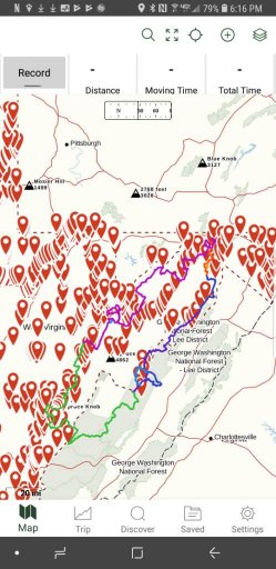
Enthusiast I

Member III
Enthusiast I
https://www.gaiagps.com/public/TAfanGVd5MDFfFG8x1qtrzwE/TAfanGVd5MDFfFG8x1qtrzwE?layer=mapquestaerialDo you have a better copy of the map or GPX I could load in google? I may be able to offer some options down in the Bath/ Highlands Co region.

Off-Road Ranger II
6330
Is it mostly motorcycle trails?TerryD will have good info for you and you might also want to check the Mid-Atlantic BDR. https://ridebdr.com/MABDR
Member III
Enthusiast I
Thank you! I will look into it@Adam Borchardt your GaiaGPS description lists that your route passes Dolly Sods. I believe I once read that the Pass is closed/gated in winter. -Just a heads up that you may look into.
My info from here:
https://expeditionportal.com/forum/threads/dolly-sods-wv-winter-crossing.184456/
It was created for adventure bikes but I have done Va and WVa in my truck, no problem.Is it mostly motorcycle trails?

Influencer I
Trucks should have no problem, I have done section 2 and 3 in my truck and on my bike with no issue.Is it mostly motorcycle trails?
Member III
I'd like to know about those if you're inclined to share.Looks like you have most of the good stuff covered from H-Burg south from what I know of that area. I would like to spend some more time exploring up there this summer myself. Are you familiar with Flag Pole knob and the Union Springs trail?
Member III
Both can get pretty crowded because of the amount of folks who know about it. The trail from Switzer Lake to the top of the mountain has one kinda rough spot but if you swing wide left, you'll miss most of it. There's also a water hole near the top that can get pretty deep when it's been raining. It's hard bottom and not much to it really.I'd like to know about those if you're inclined to share.
Great info, thanks for sharing it.Both can get pretty crowded because of the amount of folks who know about it. The trail from Switzer Lake to the top of the mountain has one kinda rough spot but if you swing wide left, you'll miss most of it. There's also a water hole near the top that can get pretty deep when it's been raining. It's hard bottom and not much to it really.
The Union Springs side is usually not as crowded but has some more difficult obstacles. Nothing my open/open X has had any trouble with though. There are a few muddy spots on the way up that I personally avoid and a bunch of water holes on the trail that are just dirty water. There's places to camp all along the trail, this time of year I would try to avoid any of the ridge spots because of the temperature drop you get at those altitudes and pretty steady winds.
If you continue along from the field west, you'll come to Reddish Knob and the FS road that leads over to West Augusta. There's a BUNCH of camping along that road and even North River Campground that I spent a night in two years ago. There's fishing around that area as well.

Traveler III
I get back from Iceland the 4 Th I will be around the 5th if you are in the area may I can join you , I use to live about 10 min from trail head and spent many years in the area .Great info, thanks for sharing it.
Enthusiast I

Enthusiast III
Member III
So I'm not a fan of that Gaia basemap. Looks mostly like a route I worked out for myself a few years ago from Millboro north. The ride over to Lake Moomaw is mostly paved but it's nice over there. Not sure how much camping is open this time of year though.

Pathfinder III
Enthusiast III

