Understanding Off-Road Signs?

  • HTML tutorial

HighSierraOverland

Rank III
Launch Member

Advocate II

761
Fresno, CA
Member #

4552

Can anyone give a better explanation, or more detailed information on the backroad/off-road signs we run across on trails. I'm not sure if there is a specific name for them, but they are the ones that sit probably 2-3ft off the ground. The small brown, thin column like ones.

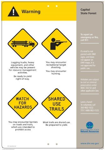
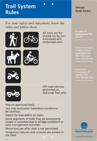
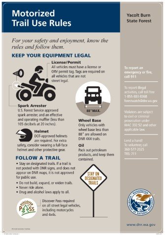
Usually they have the road names written (such as 6SX) on them along with what is allowed on them (OHV, horses, etc), but I've noticed occasionally I'll run across some that have different markings that I'm not used to. For instance when you are traveling on some of these roads, you'll have a ton of the markers on both sides, but they appear to just have solo or double digit numbers. Are those private land? I thought I read one time it was for horse trailers? Or people who own horses? Really not sure if that's right.

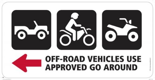
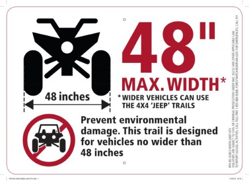
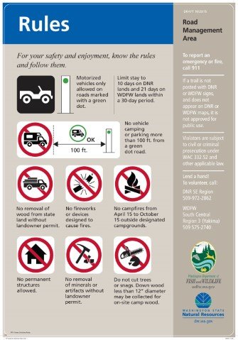
Additionally, the one that shows a sedan style car with a cross through it. Is that for more lower sitting cars? Vehicles in general? I noticed one had that, but it literally had nothing more, nothing allowing horses, OHV, etc.

Hopefully I'm not being too short with explaining it. I can always take pictures if necessary, but I assume most of you would know what I mean.

Hopefully there's something online that explains this all and I've completely missed it.
 

HighSierraOverland

Rank III
Launch Member

Advocate II

761
Fresno, CA
Member #

4552

My gut feeling tells me the same, but the fact that they have nothing else for vehicles is what worries me. Satellite view you can definitely see tire tracks.
 

NW David

Rank IV
Launch Member

Advocate II

1,293
Gig Harbor, WA
Member #

4721

TBH after perusing the site, There wasn't a whole lot of information there for what you were asking.

So I called the DNR directly and they said that there really isn't a off-road sign consolidated list like the DOT has for road signs.

The lady I spoke to at the DNR said she would dig me up something if she can. More to follow


Sent from my iPhone using OB Talk
 

HighSierraOverland

Rank III
Launch Member

Advocate II

761
Fresno, CA
Member #

4552

I noticed most were the pretty standard signs you'd see on the road. I emailed my contact in the National Forest, but he takes a little bit to respond sometimes. I'm sure someone here will know as well once they start getting home from work.
 
  • Like
Reactions: NW David

NW David

Rank IV
Launch Member

Advocate II

1,293
Gig Harbor, WA
Member #

4721

yea, you would think the DNR would be just as thorough as the DOT.

Either way i see a new Boot camp article in the near future regarding this.
 

druff6991

Rank IV
Launch Member

Advocate II

1,118
Carlsbad NM
Member #

4542

My gut feeling tells me the same, but the fact that they have nothing else for vehicles is what worries me. Satellite view you can definitely see tire tracks.
Well I mean trucks and jeeps can leave the tire tracks. And usually when it excludes cars, it's implied that trucks and jeeps are required. Just my take on it

Sent from my SAMSUNG-SM-G891A using OB Talk mobile app
 

HighSierraOverland

Rank III
Launch Member

Advocate II

761
Fresno, CA
Member #

4552

So I went out that way after getting too damn curious. I found another one eventually on another road, as the first one was a bit worn. It says, "Not Recommended." I went down it ZERO problems in the CR-V, and honestly if you knew how to drive you could probably make it in a Civic too. Not all roads are that way I'm sure, but at least that was easy to find out thanks to a newer sticker.

Though one road had it, and then 50ft away at the gate said "Road closed to all motor vehicles." Thought that was a bit odd, apparently it's only for hiking and horses, but clearly it's a road. Odd.
 

The other Sean

Rank V
Launch Member

Pathfinder I

2,271
Minneapolis
Member #

2292

These things are going to vary state by state and even county by county. One thing to take in to consideration is weather or not the area is considered open unless marked or considered closed unless marked open.
 

Lifestyle Overland

Rank VI
Founder 500
Member

Pathfinder II

4,387
United States
First Name
Kevin
Last Name
McCuiston
Member #

0102

If you're traveling in a National Forest you are required to possess a MVUM (Motor Use Vehicle Map) which will list all the LEGAL trails, what types of travel is permitted on those trails, as well as any seasonal travel restrictions. You can pick these up from the local ranger station or download them (PDF) from the National Forest's official website. There are also a few apps that are now being recognized as acceptable substitutes for hard copies and pdfs, but I recommend getting the official version from the ranger station if at all possible. (electronics can die, apps can crash, etc.)
 

NW David

Rank IV
Launch Member

Advocate II

1,293
Gig Harbor, WA
Member #

4721

Impressively I did get a yesterday though I now see the need to alter my OB notification settings. I almost missed her email. Here is what she said. I removed her contact info for her privacy and safety.

Hello, David,

Is this the type of information you are looking for? If so, I can send you the appropriate sign for the various landscapes you are interested in using.

Typically, on each landscape, there would be signs on a kiosk telling users what modes of transportation are allowed or not allowed on trails, along with what is banned in the area. I recall one of your questions dealt with the red circle and cross. That means the portrayed activity is not allowed. A trail is never closed due to difficulty. It is open or closed for particular uses. We are currently working towards a ranking system, to denote the difficulty of particular trails.

I hope this helps. Please let me know if I am close or way off on answering your questions.

The military side of me cringed, the realist laughed and said you knew this would happen and the optimist still hopes there is more. So I inevitability replied with. Again names taken out

WADNR Employee,

Thank you so much for your help and fast reply! Sadly no that isn't what I was looking for.

Not to be ungrateful, I was hoping to locate something more comprehensive. Similar to the DOT's manual on traffic control devices.

POC Contact Information: DOT employee

https://mutcd.fhwa.dot.gov/services/publications/fhwaop02084/

I know hyperlinks and government don't always mesh but that is a (link to a) DOT brochure with a very complete listing of the various US road signs and their respective meanings.
I think we may be out of luck for the moment but I can see the need for DNR for each state to collaborate and get something. IMO It's less about knowing them all and more about where to find the info when I need it.

For the record it felt less long winded while I was typing.


Sent from my iPhone using OB Talk
 
  • Like
Reactions: HighSierraOverland

Wolfy

Rank V

Advocate I

1,723
Reno
The brown signs with white numbers vertically are forest road markers. The road numbering is usually something lis 6S30 or 29N450b.

They are a sequence based on location in a map grid. The S or N meaning north or south of some transect. All the roads in a grid will have the same prefix with a sequential suffix and spur roads will have a letter designation. I don't know the schema specifically, but that's how it seems to work in the west.

The sedan slash means no street vehicles. Or you will get stuck or some such. I believe they put those on unimproved roads or roads that are not maintained. Whereas roads that are specifically maintained as jeep trails will get the jeep icon. I don't see that one much anymore.

-M
 
  • Like
Reactions: BCBrian

HighSierraOverland

Rank III
Launch Member

Advocate II

761
Fresno, CA
Member #

4552

These things are going to vary state by state and even county by county. One thing to take in to consideration is weather or not the area is considered open unless marked or considered closed unless marked open.
Really? I would have thought the National Forest land would all follow the same types of signage and what not. Obviously State Parks and what not I could see being different, but that's good to know.

If you're traveling in a National Forest you are required to possess a MVUM (Motor Use Vehicle Map) which will list all the LEGAL trails, what types of travel is permitted on those trails, as well as any seasonal travel restrictions. You can pick these up from the local ranger station or download them (PDF) from the National Forest's official website. There are also a few apps that are now being recognized as acceptable substitutes for hard copies and pdfs, but I recommend getting the official version from the ranger station if at all possible. (electronics can die, apps can crash, etc.)
Interesting, didn't realize that was a requirement. I can understand for private land and what not, but it's pretty easy here for the most part to tell. I always never travel down one if I'm not sure. However since pulling them, I noticed the road that said "no motor vehicle access," is actually listed as being able to be driven on according to the map. So what does one do in that case?

The brown signs with white numbers vertically are forest road markers. The road numbering is usually something lis 6S30 or 29N450b.

They are a sequence based on location in a map grid. The S or N meaning north or south of some transect. All the roads in a grid will have the same prefix with a sequential suffix and spur roads will have a letter designation. I don't know the schema specifically, but that's how it seems to work in the west.

The sedan slash means no street vehicles. Or you will get stuck or some such. I believe they put those on unimproved roads or roads that are not maintained. Whereas roads that are specifically maintained as jeep trails will get the jeep icon. I don't see that one much anymore.

-M
From what the Ranger told me this morning, the sedan slash is just for low clearance vehicles. Even though the CR-V is a "street vehicle" I didn't have any issues. Or are street vehicles only referred to as low vehicles? Just trying to get all the correct terminology down.
 
  • Like
Reactions: NW David

NW David

Rank IV
Launch Member

Advocate II

1,293
Gig Harbor, WA
Member #

4721

If you're traveling in a National Forest you are required to possess a MVUM (Motor Use Vehicle Map) which will list all the LEGAL trails, what types of travel is permitted on those trails, as well as any seasonal travel restrictions. You can pick these up from the local ranger station or download them (PDF) from the National Forest's official website. There are also a few apps that are now being recognized as acceptable substitutes for hard copies and pdfs, but I recommend getting the official version from the ranger station if at all possible. (electronics can die, apps can crash, etc.)
I don't think you are "required" to have them but I will make sure ask the DNR employees that too. Lord knows I don't want to be caught with my pants down
 

NW David

Rank IV
Launch Member

Advocate II

1,293
Gig Harbor, WA
Member #

4721

ALCON,

I was excited to see that she had responded to me again later this morning.

Hello, David,
Well, I have asked around and it seems we don’t have what you are looking for. We use many of the National Park icons, which are fairly universally known. We have many icons that our graphics person creates as well. As I stated before, on most landscapes, a sign will state what is allowed and not allowed. Typically, the icon will be used to reinforce the words, but we normally would not use an icon alone. It would always be in conjunction with some verbiage, or a legend to explain the meaning. What I sent yesterday was an example of a sign used on a particular landscape. We do have all of these signs (over 500 individual), but they are not linked to the external website, so you could not view them. I would have to send you each one. If you have a particular landscape area in mind, I could send the appropriate signs.

I know this isn’t the answer you’d hoped for, but I’m sorry to say, it’s all I’ve got. If you have more specific questions about a particular icon or a particular landscape, please don’t hesitate to get in touch with me again.


I’m including a few individual signs for you.

RTC2-4_Be_Safe_12x18-D_jpg.jpgRTC-5-Go-Around-B-24x12_jpg.jpgRP6-50-18x24-No-Driving-In-Ditches_jpg.jpgRP6-19_24x36_Advance%20Riders_jpg.jpgRP4-85-12x8_5-Width-Limit-ATV_jpg.jpgRP3-1-Cap-For_18x26_Area%20or%20Rec%20Site%20Warnings_jpg.jpgRP2-SP-1_18x26_Trail%20System%20Rules_jpg.jpgRP2-18x26-Yacolt-Moto-1-Trail-Rules_jpg.jpgRP1-Green-Dot_18x26%20Area%20Rules-C_jpg.jpg
After reading her correspondence, I gave her a call to verbally to thank her for all of her assistance and what a pleasant experience that was. She was understanding of what was needed and very helpful. But ultimately there is not Overarching Document similar to the DOT, and with government budgets being what they are she also lamented that there probably isn't going to be one in the near future. :fearscream:

Good news like what @Lifestyle Overland was saying each park will have a station and that station should have the printouts/pdf pamphlet. And if theres a will theres a way to get what you need. Though at least not in Washington state it confirmed to be not required on state parks or national forests. Thank goodness too cause if they were, I have been doing it wrong. pucker factor... gone!

There is something here called the Discover, forestry service and national parks passes/permits that you ARE required to have when traveling on those respective lands. maybe that was what was intended?

regardless, I certainly learned a lot. I just hope I was able to help
 
  • Like
Reactions: HighSierraOverland

Lifestyle Overland

Rank VI
Founder 500
Member

Pathfinder II

4,387
United States
First Name
Kevin
Last Name
McCuiston
Member #

0102

Interesting, didn't realize that was a requirement. I can understand for private land and what not, but it's pretty easy here for the most part to tell. I always never travel down one if I'm not sure. However since pulling them, I noticed the road that said "no motor vehicle access," is actually listed as being able to be driven on according to the map. So what does one do in that case?
Apparently the MVUM is the legal document... so that's a tough one. I've also had the opposite problem where the road is obviously used, but not on the map. At the end of the day they can write you a ticket based on the map. So use your own judgement. I've met rangers on these "unlisted" roads and they just waved as they drive by... but New Mexico is terrible at updating their documents. Makes it tough on us trying to do the right thing.
 
  • Like
Reactions: HighSierraOverland

Lifestyle Overland

Rank VI
Founder 500
Member

Pathfinder II

4,387
United States
First Name
Kevin
Last Name
McCuiston
Member #

0102

I don't think you are "required" to have them but I will make sure ask the DNR employees that too. Lord knows I don't want to be caught with my pants down
I can't find a document that states the requirement myself, but I've been asked if we have one by several rangers in the past, as have others on this forum. The rangers have verbally stated it's a requirement so I err on the side of preparedness. :)
 
  • Like
Reactions: NW David