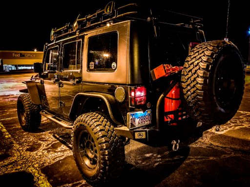
trailspinTV's 6 Weeks on the TAT

  • HTML tutorial

trailspinTV

Rank VI
Launch Member

Influencer II

3,698
Peoria, IL
Member #

8207

Hey OB friends, I just wanted to start an official thread about my upcoming trip on the Trans America Trail (route from east coast to west coast all off-road) so that it is easier to coordinate with other OB members in case they want to join in. The goal here is to create an official overland route, document it with pictures, video, GPX files, weather and terrain reports and more. In my research, I found it difficult to plan this properly due to the lack of information regarding a 4x4 vehicle on the trail, since it was originally designed for dual sport motorcycles.

We plan to post daily (or as close to daily as possible) vlog-style videos on our YouTube channel, which will contain information regarding the section we tackled that day in the description of the video. We are also planning on free camping only, which may take us a bit off of the trail each night, but we felt it was important to mark these locations for those who would prefer to avoid camping fees. Details all the way down to what gas stations offer a propane refill or exchange, how much gas is at each stop, and which places allow you to fill your water storage will be included for every checkpoint.

This trip has been my main focus for the past few months, as I've been building up my Jeep more quickly than I had hoped ($$$) to make sure that a single vehicle can complete the trip safely without the support of another vehicle in the event of a snag. I am hoping that you all would have some input as far as what kind of data we should collect, since we plan to make all of this information readily available here and through our website. I basically want to make it as easy as possible to pick the route up at any point along the trail, and help overlanders know exactly what they're up against to be as prepared as possible. If this isn't your style, you don't have to pay any mind. But, if going prepared or satiating your curiosity about this particular trail is something you're interested in, please follow along. Of course, we'd love to hear from you!

In the next post, I'll be adding our schedule from April 29th to May 16th, where we'll be arriving in Flagstaff for Overland Expo West May 18th through the 20th. From there, we'll be backtracking to Moab and then continuing on the actual trail through Utah, Nevada, and ending on the coast of Oregon. If time allows, I'll either head down the Pacific Coast Highway, or wrap around the other direction to head through Idaho, Montana, and South Dakota on my way back to Illinois. The second half of the trip is still loosely scheduled at this point, but as it gets built I will be posting additional checkpoint dates to the post below this one.

So that you can find our channel, here is a link to our latest "VLOG" discussing what I think of the 4" X-Series Lift from Rough Country and Falken's 35" mud terrain tires as we tested them both for the first time at Badlands Off-Road Park in Indiana:


trailspinTV

Rank VI
Launch Member

Influencer II

3,698
Peoria, IL
Member #

8207

Here is the schedule. Anyone from Overland Bound is welcome to meet us along this route at any point. We obviously can't guarantee that these dates will be concrete, as we may hit some snags along the way, but we'd like to encourage you guys to join us and have some fun. We'd love to do some rig walkarounds and feature them on our channel as well, so even if you can only join us for a few hours, we'd love to have you!

SCHEDULE

4/29/18 - TAT Section 01 Cape Hatteras NC to Stella NC - 125 miles

4/30/18 - TAT Section 02 Havelock NC to Newton Grove NC - 111 miles
4/30/18 - TAT Section 03 Newton Grove NC to Candor NC - 98 miles
4/30/18 - TAT Section 04 Candor NC to Statesville NC - 105 miles


5/1/18 - TAT Section 05 Statesville NC to Bakersville NC - 125 miles
5/1/18 - TAT Section 06 Bakersville NC to Maggie Valley NC - 107 miles
5/1/18 - TAT Section 07 Maggie Valley NC to Deals Gap NC - 96 miles


5/2/18 - TAT Section 08 Deals Gap NC to Charleston TN - 103 miles
5/2/18 - TAT Section 09 Charleston TN to Pelham TN - 111 miles
5/2/18 - TAT Section 10 Pelham TN to Goodspring TN - 119 miles-


5/3/18 - TAT Section 11 Goodspring TN to Counce TN - 96 miles
5/3/18 - TAT Section 12 Counce TN to Ripley MS - 96 miles
5/3/18 - TAT Section 13 Ripley MS to Tillatoba MS - 127 miles


5/4/18 - TAT Section 14 Tillatoba MS to Crenshaw MS - 66 miles
5/4/18 - TAT Section 15 Crenshaw MS to Marvell AR - 65 miles
5/4/18 - TAT Section 16 Marvell AR to Beebe AR - 98 miles
5/4/18 - TAT Section 17 Beebe AR to Hector AR - 129 miles


5/5/18 - TAT Section 18 Hector AR to Oark AK - 68 miles
5/5/18 - TAT Section 19 Oark AK to Lincoln AR - 110 miles
5/5/18 - TAT Section 20 Lincoln AR to Adair OK - 95 miles
5/5/18 - TAT Section 21 Adair OK to Dewey OK - 75 miles


5/6/18 - TAT Section 22 Dewey OK to Newkirk OK - 91 miles
5/6/18 - TAT Section 23 Newkirk OK to Alva OK - 109 miles
5/6/18 - TAT Section 24 Alva OK to Buffalo OK - 87 miles
5/6/18 - TAT Section 25 Buffalo OK to Liberal KS - 104 miles


5/7/18 - TAT Section 26 Liberal KS to Boise City OK - 117 miles
5/7/18 - TAT Section 27 Boise City OK to Trinidad CO - 153 miles


5/8/18 - TAT Section 28 Trinidad CO to La Veta CO - 72 miles
5/8/18 - TAT Section 29 La Veta CO to Westcliffe CO - 104 miles


5/9/18 - TAT Section 30 Westcliffe CO to Sargents CO - 116 miles
5/9/18 - TAT Section 31 Sargents CO to Lake City CO - 93 miles


5/10/18 - TAT Section 32 Lake City CO to Dove Creek CO - 155 miles

5/11/18 - TAT Section 33 Dove Creek CO to Moab UT - 137 miles


5/12/18 - TAT LA Section 01 Moab UT to Monticello UT - 102 miles

5/13/18 - TAT LA Section 02 Monticello UT to Hite Marina - 116 miles
5/13/18 - TAT LA Section 03 Hite Marina to Bullfrog Marina - 106 miles


5/14/18 - TAT LA Section 04 Bullfrog Marina to Boulder UT - 91 miles
5/14/18 - TAT LA Section 05 Boulder UT to Escalante UT - 41 miles
5/14/18 - TAT LA Section 06 Escalante UT to Big Water UT - 97 miles


5/15/18 - TAT LA Section 07 Big Water UT to Kanab UT - 81 miles

5/16/18 - Kanab to Flagstaff - 204 miles
 

Phil Preston

Rank V
Launch Member

Enthusiast III

2,259
Shelbyville, KY USA
First Name
Phil
Last Name
Preston
Member #

9245

Ham/GMRS Callsign
KN4LET
Service Branch
First Responder
I'll be subscribing and following along as well. This is a trip I plan to take in a year or 2 with my son, so I'm very interested.
 
  • Like
Reactions: trailspinTV

trailspinTV

Rank VI
Launch Member

Influencer II

3,698
Peoria, IL
Member #

8207

I'll be subscribing and following along as well. This is a trip I plan to take in a year or 2 with my son, so I'm very interested.
I hope we can be informative and make it as easy/fun as possible! Thanks for following along. We're eager for feedback so feel free to reach out through here, via comments on YouTube, or you can even email me at brandon@trailspin.tv and I'll get right back to you.
 

Keboh

Rank III
Launch Member

Advocate II

628
Kansas City
Member #

9891

Following this, as well. We are going from Oklahoma to Moab more-or-less using the TAT in late June. This would be really helpful for ideas on routes!
 
  • Like
Reactions: trailspinTV

Kent R

Executive Director
Staff member
Mod Team
Moderator
Member

Pathfinder III

5,200
El Dorado, Ca
First Name
Kent
Last Name
Reynolds
Member #

1632

Ham/GMRS Callsign
K6KNT
Service Branch
Retired Firefighter
Ill be watching looks like a very doable schedule
 
  • Like
Reactions: trailspinTV

Etoimos

Rank V
Launch Member

Member III

2,779
Peyton, CO
First Name
Keith
Last Name
Upton
Member #

11810

I'll be following along as well. I've looked at the TAT a couple of times and also noticed the lack of non motorcycle details. It's too bad you are planned to reach Westcliffe CO in the middle of the week. My mom has a place down there and if it was over a weekend, we could me you for a night of camping and show you a fun trail and a mountain lake. You could also do a day trip over to the Great Sand Dunes from there.
 

Keboh

Rank III
Launch Member

Advocate II

628
Kansas City
Member #

9891

I'll be following along as well. I've looked at the TAT a couple of times and also noticed the lack of non motorcycle details. It's too bad you are planned to reach Westcliffe CO in the middle of the week. My mom has a place down there and if it was over a weekend, we could me you for a night of camping and show you a fun trail and a mountain lake. You could also do a day trip over to the Great Sand Dunes from there.
I traced as much of the TAT through CO using street view on Google Maps and there are definitely a few single-track trails it has you go on.

I made a track that follows the TAT mostly but diverts off where necessary for my planned trip this summer. If I have time, I'll post it up.
 

trailspinTV

Rank VI
Launch Member

Influencer II

3,698
Peoria, IL
Member #

8207

I'll be following along as well. I've looked at the TAT a couple of times and also noticed the lack of non motorcycle details. It's too bad you are planned to reach Westcliffe CO in the middle of the week. My mom has a place down there and if it was over a weekend, we could me you for a night of camping and show you a fun trail and a mountain lake. You could also do a day trip over to the Great Sand Dunes from there.
We'll keep this in mind and see how it all plays out. We may opt to avoid Overland Expo which would change a chunk of that schedule and whatever schedule was to follow. Hard to justify spending that much money on tickets just to be tempted to buy more gear we won't have room for. I mean, the classes are cool and all, but that's a lot of dough.
 
  • Like
Reactions: Eric Neal

trailspinTV

Rank VI
Launch Member

Influencer II

3,698
Peoria, IL
Member #

8207

I traced as much of the TAT through CO using street view on Google Maps and there are definitely a few single-track trails it has you go on.

I made a track that follows the TAT mostly but diverts off where necessary for my planned trip this summer. If I have time, I'll post it up.
I keep hearing that "95% of the TAT can be done in a 4x4" so I'm guessing CO is where things get tricky. I'm going to have to do the same research myself, but if you've already come up with something, that would be incredibly helpful as we're already pretty swamped in planning the rest of it. It's making less and less sense to hit Overland Expo as it's a huge diversion, and gives us less time to explore UT and CO in our allotted 6 weeks.
 

Keboh

Rank III
Launch Member

Advocate II

628
Kansas City
Member #

9891

I keep hearing that "95% of the TAT can be done in a 4x4" so I'm guessing CO is where things get tricky. I'm going to have to do the same research myself, but if you've already come up with something, that would be incredibly helpful as we're already pretty swamped in planning the rest of it. It's making less and less sense to hit Overland Expo as it's a huge diversion, and gives us less time to explore UT and CO in our allotted 6 weeks.
I'll post up our planned route (and alt. routes) when I have time this week. Should get you all the way through CO more-or-less following the TAT. Just have to remember to do it after work!
 

WIGGLE

Rank V
Launch Member

Enthusiast II

1,428
Carmel, IN
Member #

10385

Following! We'll be setting out on our TAT trip April 20th and wrapping up our first section (all the time I can take off work) on April 28th. Good luck with your trip, I'll be posting some updates as we go so hopefully they'll help you guys out on your trip too.
 
  • Like
Reactions: trailspinTV

trailspinTV

Rank VI
Launch Member

Influencer II

3,698
Peoria, IL
Member #

8207

Only 11 days left until the start of the Trans America Trail. This is so CRAZY! Months of planning and the date is sneaking up on me. Just added the rear bumper and tire carrier a few days ago, and the quick fists for the axe and shovel last night. This has been so much fun to build, and it's been a wild 6 months!

I hope you guys follow along at our YouTube channel, as we'll be doing as-daily-as-possible video uploads of the trip. 6 weeks, just us, our rig, and the dirt. On on!

DBBB IG edited 4.jpg
 

Phil Preston

Rank V
Launch Member

Enthusiast III

2,259
Shelbyville, KY USA
First Name
Phil
Last Name
Preston
Member #

9245

Ham/GMRS Callsign
KN4LET
Service Branch
First Responder
Watching as well, all info will be welcomed as I will start my new build for my son and I to do the same trip when the Jeep diesel is released later this year. Safe travels!


Sent from somewhere in time...
 

skip371

Rank 0

Contributor I

60
This is a trip I did last year as far as Moab. Although clearly you have put a great deal of planning in this, probably more than I did, I will try to briefly make a few comments. this is a beautiful and really awesome adventure. The nature of the trip really depends on The weather/rain. When dry you can make the trip to colorado in a subaru 4x4. When wet, some parts have the most challenging mud Ive ever been through for miles, i ran into a number of flooded roads and washed out bridges so be prepared to detour if its been raining- my experience is that you are going too early to make it from Salida , CO to Moab- for me the high mountain passes were still snowed in and were impassable. GPSKevin has already prepared a gps route that is available and Sam Corelli at TranAmtrail has really all the maps noting milage camping areas, gas stations/lodging .
He even has contacts in The western US who have opened there ranch/ farm for camping for those traveling the TAT. I camped on the Moore farm in Oklahoma... super nice family.
Have a great time and keep us posted. I am headed out to Salida in July to finish part of the TAT and the heading north on the continental divide trail to canada:). Hope to meet you on the trail.


Sent from my iPhone using Tapatalk