Tablets and tablet software

  • HTML tutorial

nickburt

Rank VII
Launch Member

Creator III

5,613
Wallasey, Wirral. UK
First Name
Nick
Last Name
Burt
Member #

2714

I'm currently running an Ipad Air (GPS/WiFi and GSM - or run it off my 'phone's hotspot - 'phone has a much bigger data (3 and 4G) roaming allowance), with a variety of mapping and navigation apps. Which app(s) I use sometimes depends on where we are and what we're doing, or depends on the mood I'm in!!

I've been looking at the Delorme InReach, and have pretty much decided it's worth the investment and one of the monthly subscriptions having watched some friends of our tour Africa for 10 months using one, it was just great the way it works for the follower, and from talking to them, coupled to an Ipad in the truck, it was easy to use for them on the road.

I'm also looking at either swapping the Ipad, or supplementing it with a GPS Globe GlobeXplorer, but not sure it'll do much more than the trusty Ipad, except it's a lot more rugged for outdoor use, but so can the Ipad be, given a decent case. Jury is out ....

But, it got me thinking, there must be apps out there that will do some of the same stuff. The thing I'm looking for the most (because I don't have it at the moment) is the ability to be tracked, more or less live.
I've tried a few, and none seem to be linkable to the likes of Google Maps/Earth for followers at home to see where we've been and where we are, for more than either a one shot now location report, or for much more than the last 24 hrs, after which the record is lost and therefore followers can't see any history of the trip concerned.

Now, I realise a GSM connection is needed for this work properly, which is OK for me with a fairly large data allowance on my 'phone. If it's out of GSM range, then an update of stored info would be the solution, once3 a GSM connection becomes available.

Recording routes for use later is OK, I use the likes of MotionX for that, or here in the UK and some of Europe, Memory Map and Viewranger are OK, but clunky to upload from.

I guess what I'm really looking for is InReach as an app on the Ipad .... ha ha ... like that's going to happen!!

Thoughts and ideas??
 

Gunnermoose

Rank V
Launch Member

Advocate II

2,741
Mesa, Arizona
Member #

1599

I guess what I'm really looking for is InReach as an app on the Ipad .... ha ha ... like that's going to happen!!
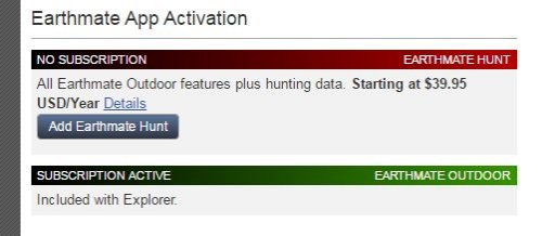
Goto the iTunes app store and download Earthmate. This is the app for the inReach. As long as you have the inReach Explorer, you will have full map downloads and planning capability with the inReach. I have been an avid user of the inReach since it was launched. It is my goto navigation and "in the bush" communication tool. Additionally, the app has a capability to purchase ($29 ish) plan to just use the app as an inReach device.

inReach Plans.JPG
 
  • Like
Reactions: k9sar and 1Louder

nickburt

Rank VII
Launch Member

Creator III

5,613
Wallasey, Wirral. UK
First Name
Nick
Last Name
Burt
Member #

2714

I hadn't delved deep into Earthmate because I always thought it only worked with inReach, but ..... everyday is a school day, now looking at the Ios App and what World base maps is going to cost .... This could be the solution I've been looking for. Thanks for the help.
 

nickburt

Rank VII
Launch Member

Creator III

5,613
Wallasey, Wirral. UK
First Name
Nick
Last Name
Burt
Member #

2714

Doh, penny has just dropped, once you get the app and subscription, all maps are included, with the exception of the Hunt version.
This is getting better ...
 

nickburt

Rank VII
Launch Member

Creator III

5,613
Wallasey, Wirral. UK
First Name
Nick
Last Name
Burt
Member #

2714

Been playing with it a bit today. Works well and doesn't seem to use much data. I have the Ipad connected via my Iphone hotspot, mainly because the phone data package is much bigger (20GB/month).
Only issue so far with the app on the Ipad is that I have auto lock set up on the phone (a function of one of my email accounts forces auto lock to be on all the time), once this times out, if the screen hasn't been touched the pad goes to sleep and eventually drops the hot spot and therefore tracking doesn't update until the connection is re-established. Not really and issue though, just needs the screen to be tapped now and again, or let it go off for a while anyway. As soon as the data connection is re-established, the tracking is updated within minutes.

The Europe map could do with a more detailed level, but I guess for the price, it's OK.
 

nickburt

Rank VII
Launch Member

Creator III

5,613
Wallasey, Wirral. UK
First Name
Nick
Last Name
Burt
Member #

2714

This app is so easy to use, and from my experience when following some friend on their trip in Africa, it's a doddle to use as a follower and, more inportantly, if you needed to rescue someone, thier location is easy to monitor.
One other consideration is that the app doesn't sync unless it's the active app (due to apple restrictions), but it does continue to record tracking data if running in the background.
From the Delorme website:
"The iOS Earthmate can collect log information while running in the background on an iOS device but due to Apple restrictions it cannot Sync data unless it is the active app on the mobile device. To ensure that the information is Synced open the app on the iOS device and leave it on the screen as the active app"

So far, impressed with it as a mobile app.
 
  • Like
Reactions: k9sar

nickburt

Rank VII
Launch Member

Creator III

5,613
Wallasey, Wirral. UK
First Name
Nick
Last Name
Burt
Member #

2714

Just a follow up on this.
Been using it on both the Ipad and Iphone. Dead easy to use and good for others to track you. Money well spent.
 

SpikeMD

Rank V
Member

Enthusiast III

1,751
Granite Bay, CA
First Name
Ted
Last Name
Speicher
Member #

3127

Ham/GMRS Callsign
WJ6SPK
I'm a big fan of the DeLorme (now Garmin) InReach devices synced to my android tablet. Tracks me and lets other follow. Used it last month far from cell service for text messaging and in a dire emergency, has search and rescue button.

I also use the Earthmate software but find it hard to import gpx tracks and routes. I have found Gaia GPS to be superior plus many people upload their own tracks which you can download go the tablet. Going through other user routes also gives you a better idea of travel times and terrain. InReach for GPS signal and GaiaGPS for mapping works well for me.

For backup, I download Google map areas for roads when our of cell service.
 
  • Like
Reactions: DaveD and k9sar

Texassailor

Rank III
Launch Member

Contributor III

684
Austin, TX
Member #

8476

I needed something for remote areas without cell service (like Big Bend Natl Park). So I paired my iPad Air2 with a Bad Elf Pro using the LeadNav iOS software. I was able to download maps/satellite hi-res images within LeadNav that worked great!

In the desert, the hi-res images were better than comparable GoogleMaps images (which would have required cell service to access).

It was great to pre-plan my trip at home using LeadNav using Google Maps. I was able to check out backcountry primitive campsites and set waypoints for each one I was interested in. I also was able to plan routes. Once we entered the park and headed off on the backcountry roads/trails, we relied on the download hi-res satellite images and the previously recorded waypoints and routes. Awesome solution. I believe the hi-res maps were part of a subscription service . . . cost of which I considered "insurance" just like the Iridium sat phone we rented for the trip. Never used the sat phone. Better have it and not need it, than need it and not have it.


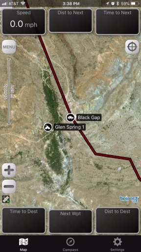
Here is a screen-shot of LeadNav running on my iPhone 6S Plus; here I am viewing the Black Gap waypoint from my office . . . so no speed, direction, etc.. The screen is a bit more elaborate on the iPad with a Heads Up Display. I can share waypoints and the like between all my iOS devices (phone, tablet, etc) using AirDrop.

LeadNav.jpg
 
  • Like
Reactions: k9sar

Texassailor

Rank III
Launch Member

Contributor III

684
Austin, TX
Member #

8476

BTW, LeadNav is designed more for offroad racing like the Baja 1000. They also have hardware/software combos and the ability through sat phones to allow others to track you.
 

AG Sheep

Rank IV

Traveler I

1,250
Maryland
Whats the skinny on utilizing a tablet as a GPS? Does it need some sort of mobile data or can it utilize the GPS features with just the application?
 

nickburt

Rank VII
Launch Member

Creator III

5,613
Wallasey, Wirral. UK
First Name
Nick
Last Name
Burt
Member #

2714

Whats the skinny on utilizing a tablet as a GPS? Does it need some sort of mobile data or can it utilize the GPS features with just the application?
My Ipad works well with just it's GPS. Mobile data not needed, as long as you're using downloaded map data etc... If you want to use the likes of Google Maps/Earth or other app that has it's data on line, then you will use up data on mobile network.
 

AG Sheep

Rank IV

Traveler I

1,250
Maryland
My Ipad works well with just it's GPS. Mobile data not needed, as long as you're using downloaded map data etc... If you want to use the likes of Google Maps/Earth or other app that has it's data on line, then you will use up data on mobile network.
I am running an Android so I will have to tinker with this a bit. Thanks for the info!
 

TnWalrus

Rank IV
Launch Member

Advocate III

1,346
Memphis, TN
Member #

8440

My iPad is WiFi only so no GPS, but you can get a Bluetooth GPS and connect it to your iPad then use this if you have WiFi only. Gaia is an extremely popular app, and with a yearly subscription, you get access to a number of upgraded maps. The web site also has routes or you can get routes from friends and import them to the app.
Gaia also allows you to download maps for off line use.
 

Joe Mayernik

Rank I
Launch Member

Member I

271
Park City
First Name
Joe
Last Name
Mayernik
Member #

18697

I take a cheap laptop with me. Prior to any trip I use the program HTTrack https://www.httrack.com to download and store websites for offline use with info on the area I'm traveling to to along with any maps. I also have MapSource installed. On the laptop I have also downloaded PDF's of First Aid and Back Country Medical Aid for quick reference and searches. Basically any reference guides I think I would need I install
 
  • Like
Reactions: nickburt

nickburt

Rank VII
Launch Member

Creator III

5,613
Wallasey, Wirral. UK
First Name
Nick
Last Name
Burt
Member #

2714

I take a cheap laptop with me. Prior to any trip I use the program HTTrack https://www.httrack.com to download and store websites for offline use with info on the area I'm traveling to to along with any maps. I also have MapSource installed. On the laptop I have also downloaded PDF's of First Aid and Back Country Medical Aid for quick reference and searches. Basically any reference guides I think I would need I install
Haven't used MapSource for a long time, not since the release of Basecamp - might resurrect it.