SW Arkansas (Texarkana) new member
- Thread starter texarkanacard
- Start date


Influencer II

Member III
Hello Tony (@texarkanacard ), welcome from Oklahoma. You have some good trails to choose from up in the Ouachita and Ozark National Forest.
You are in the Southwest Region. Check out the Southwest Region sub-forum for local information and involvement opportunities.
Here is the link to the forum calendar and Meet-Up event page: Overland Bound Meetups
Or to check out what other members are planning go here: Overland Trip Planning
I am the SW Region Member Rep so if you have any questions let me know.
Thanks Prerunner!Hello Tony (@texarkanacard ), welcome from Oklahoma. You have some good trails to choose from up in the Ouachita and Ozark National Forest.
You are in the Southwest Region. Check out the Southwest Region sub-forum for local information and involvement opportunities.
Here is the link to the forum calendar and Meet-Up event page: Overland Bound Meetups
Or to check out what other members are planning go here: Overland Trip Planning
I am the SW Region Member Rep so if you have any questions let me know.
Member III
I really need to make it over that way soon. Arkansas seems to do a nice job of preserving the old homesteads, schools, churches, and such in the National Forest for the public to enjoy.

Enthusiast III
Welcome to OB! I’m not too far south of you in east Texas, but we head up to Ouchita at least twice a year. We’ve got our own forests here in ET, but they’re nothing like what you guys have up there
I've been in the to the Ozarks and Ouachitas on a couple of occasions. I'm still green when it comes to off-roading/overlanding. I bought my first 4wd about a year ago (2013 Nissan Xterra) and have done some beginner type trails with it. I think it's a lot more capable than I've done so far.
Boostpowered
Rank VI
Member III
Im up there all the time in clayton, cloudy, kiamichi, broken bow areas enjoying the forest rds and trails.
What's your secret to finding the forest roads and trails in that area. Is there somewhere to get maps? Or a good website to visit?Im up there all the time in clayton, cloudy, kiamichi, broken bow areas enjoying the forest rds and trails.
Boostpowered
Rank VI
Member III
I just look at google maps and save whatever places i find that seem good then go see if they are.
Boostpowered
Rank VI
Member III
Here is a easy aka dirt rd in arkansas if you look on the maps there is a spiderweb of dirt roads all over from this point
Dropped pin
Near Unnamed Road, Dierks, AR 71833
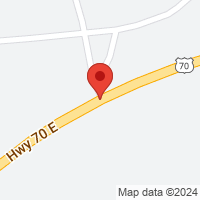
 goo.gl
Dropped pin
Near Unnamed Road, Dierks, AR 71833
34°06'41.4"N 94°02'49.1"W
Member III
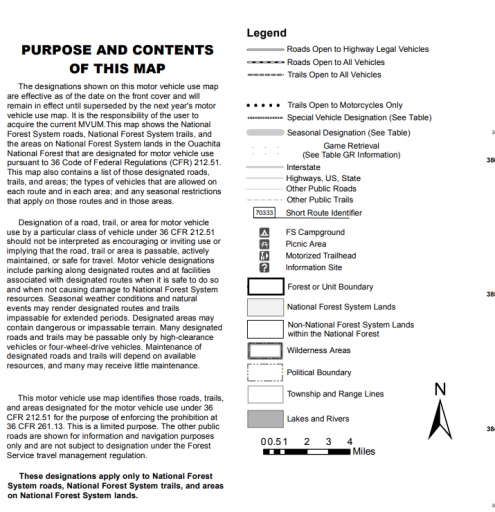
The MVUM (Motor Vehicle Use Map) is where you must go to find the open routes.
Clink on the district links towards the bottom for each map.

Clink on the district links towards the bottom for each map.
Boostpowered
Rank VI
Member III
If thats the case wolf pen gap is the only "trail" open to ohvs everything else is walking, mountain bike and horse. Until they put signs on the trails marking them off limits or not they are going to continue to have people run anywhere.The MVUM (Motor Vehicle Use Map) is where you must go to find the open routes.
Clink on the district links towards the bottom for each map.
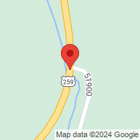
So this would be considered off limits since it in national forest but its not on any of the mmuv i can find?
Dropped pin
Near Nf 6025, Arkansas
34°35'35.8"N 94°27'17.1"W
Last edited:
Boostpowered
Rank VI
Member III
If you go to street view and look around you see the sign that says to stay on designated rds and trail. But where do i find the mvum its not listed in nfs website?
Dropped pin
Near McCurtain County, OK
 goo.gl
Dropped pin
Near McCurtain County, OK
34°14'04.8"N 94°46'26.6"W
Boostpowered
Rank VI
Member III
Straight copy of the bottom of that nfs link
FAQ
What is an Off-Highway Vehicle (OHV)?
For purposes of travel management, the Ouachita National Forest has defined an OHV as one of the following:
1. An all-terrain vehicle that travels on three or more low-pressure tires; has handle bar steering; is less than or equal to 50 inches in width; and has a seat to be straddled by the operator;
2. A vehicle with a seat or saddle and designed to travel with two wheels in contact with the ground; or
3. A vehicle 64 inches or less in width, designed to travel on four or more low-pressure tires that has a bed for cargo.
Clearly were arent talking about trucks and suvs when the the mvum is mentioned. These are going to be trails you will clearly be able to tell its not for you just by general track width on the trail or foot or horse path.
Member III
There are a couple of special use only trails, some are also open to highway vehicles but I see many routes that are open. 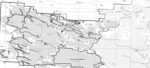
Member III
At the bottom of the link I posted previously, Oklahoma Ranger District.If you go to street view and look around you see the sign that says to stay on designated rds and trail. But where do i find the mvum its not listed in nfs website?
Dropped pin
Near McCurtain County, OK
34°14'04.8"N 94°46'26.6"W
Member III
Another good website is: Forest Service Visitor Map
It has much better image quality and you can click on the trail and get the pertinent info.
Example:
It has much better image quality and you can click on the trail and get the pertinent info.
Example:
Member III
They also mark the trails for Highway Legal Vehicles and ALL Vehicles.Straight copy of the bottom of that nfs link
FAQ
What is an Off-Highway Vehicle (OHV)?
For purposes of travel management, the Ouachita National Forest has defined an OHV as one of the following:
1. An all-terrain vehicle that travels on three or more low-pressure tires; has handle bar steering; is less than or equal to 50 inches in width; and has a seat to be straddled by the operator;
2. A vehicle with a seat or saddle and designed to travel with two wheels in contact with the ground; or
3. A vehicle 64 inches or less in width, designed to travel on four or more low-pressure tires that has a bed for cargo.
Clearly were arent talking about trucks and suvs when the the mvum is mentioned. These are going to be trails you will clearly be able to tell its not for you just by general track width on the trail or foot or horse path.