Signal Peak Information (Nor Cal)

  • HTML tutorial

Curt_JK

Rank IV
Launch Member

Enthusiast III

1,146
666 Florin Road, Sacramento 95831
Member #

7059

Ham/GMRS Callsign
KM6QMH
Howdy
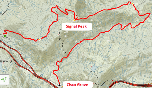
New to off roading/overlanding. I was hoping to get some information on the Signal Peak trail off the 80. From what I've read, most drive it from west to east, and the west side is difficult. I haven't found much info on the east side, and was hoping someone could confirm that side would be possible by a beginner. My plan is to drive from Cisco Grove to the peak, and then retrace my route back to Cisco Grove. Thanks for any feedback.


Attachments

rochmpr

Rank V
Launch Member

Enthusiast III

1,798
Walnut Grove, CA 95690, USA
First Name
Krister
Last Name
Favareille
Member #

2560

Accessing Signal Peak from the Cisco Grove exit it very easy. It's mostly a fire road, with some slightly challenging spots, but completely passable in a stock vehicle without any spotting. Coming in from the other side it quite difficult. There are some large rock sections, off camber, steep climbs and one spot that incorporates all three in one spot.

The pictures below are at the tricky spot coming in from Eagle Lakes.

10.jpg

11.jpg

A view from the top

VZM.IMG_20160730_135010.jpg
 
  • Like
Reactions: kg6zjl and Curt_JK

Curt_JK

Rank IV
Launch Member

Enthusiast III

1,146
666 Florin Road, Sacramento 95831
Member #

7059

Ham/GMRS Callsign
KM6QMH
Accessing Signal Peak from the Cisco Grove exit it very easy. It's mostly a fire road, with some slightly challenging spots, but completely passable in a stock vehicle without any spotting. Coming in from the other side it quite difficult. There are some large rock sections, off camber, steep climbs and one spot that incorporates all three in one spot.

Thank you for confirming this! Like the pics too, I hope to be able to do that someday.
 
Last edited:

slomatt

Rank V

Influencer I

1,723
Bay Area, CA
The west side has some nasty spots, one of which was a water pipe a sitting a foot off the trail that we had to get over. From what I remember the east side was an easy dirt road.

If you are looking for other trails in the area you could check out the following:
  • Bowman Lake / Sawmill Lake
  • Eagle Lakes
  • Mt Watson trail from Truckee to Tahoe City

 
  • Like
Reactions: kg6zjl and Curt_JK

Curt_JK

Rank IV
Launch Member

Enthusiast III

1,146
666 Florin Road, Sacramento 95831
Member #

7059

Ham/GMRS Callsign
KM6QMH
The west side has some nasty spots, one of which was a water pipe a sitting a foot off the trail that we had to get over. From what I remember the east side was an easy dirt road.

If you are looking for other trails in the area you could check out the following:
  • Bowman Lake / Sawmill Lake
  • Eagle Lakes
  • Mt Watson trail from Truckee to Tahoe City
Thanks for the info on additional trails, I'll add them to my list.
 

slomatt

Rank V

Influencer I

1,723
Bay Area, CA
Off topic, but would you have any suggestions for a nice solo run around Sac/Tahoe with good views and possible water crossing? Moving to Sac soon.. haha
The "solo" part makes it tricky since it depends on your level of experience and the capability of your rig (or how good your self-recovery gear is). :wink:

Here are some ideas.

- The eastern side of Signal Peak like we've been discussing. There are a lot of easy dirt trails in that area that lead out to lakes.
- The Bowman Lake area.
- Mt Watson trail, though watch out for snow and the last part heading into Tahoe City can be a bit rough.
- There are miles of dirt roads on the north side of highway 4, Google Calaveras Dome for some ideas.

There are many others. You might want to get a copy of "Backcountry Adventures: Northern California", it has good reviews of a lot of trails and ranks their difficulty.
 
  • Like
Reactions: billyballer

v_man

Rank IV

Advocate I

1,250
Redwood City
How was the road to deer lake? Stock height worthy?

Sent from my SM-G955U using Tapatalk
The trail goes past Deer Lake, it is moderate and a stock 4x4 could make it fine. There is a short side road that goes down to Deer Lake and that road has one very difficult section. Not recommended for unmodified vehicles...
 

mtn_man

Rank 0

Traveler I

60
Auburn
The trail goes past Deer Lake, it is moderate and a stock 4x4 could make it fine. There is a short side road that goes down to Deer Lake and that road has one very difficult section. Not recommended for unmodified vehicles...
Thanks for the response!

Sent from my SM-G955U using Tapatalk
 

Garlic Overlander

Rank V
Launch Member

Pathfinder II

2,390
Gilroy, CA
First Name
Jarad
Last Name
Derosa
Member #

6811

Jolly on Snake.jpg Keep in mind that you can still get down to Snake Lake without taking the "insanely" steep route Snake Lake trail. If you go down the Deer Lake trail you can bypass the black diamond for something most any stock rig can do so long as you take it easy. I have gone both up and down "Snake Lake Hill", and it gets your heart pumping.

http://4x4trailmaps.com/4x4Trails.php?Trail_ID=47
 
  • Like
Reactions: v_man and Randy P

Garlic Overlander

Rank V
Launch Member

Pathfinder II

2,390
Gilroy, CA
First Name
Jarad
Last Name
Derosa
Member #

6811

My best suggestion for this area from personal experience, is the Gold Valley Trail. Longer at about 19 miles, it is easy to slightly moderate perhaps in a couple spots, the scenery is tough to beat and the trail will not wear your out. Great camping, hiking and other opportunity awaits.

http://4x4trailmaps.com/4x4Trails.php?Trail_ID=81
 

mtn_man

Rank 0

Traveler I

60
Auburn
My best suggestion for this area from personal experience, is the Gold Valley Trail. Longer at about 19 miles, it is easy to slightly moderate perhaps in a couple spots, the scenery is tough to beat and the trail will not wear your out. Great camping, hiking and other opportunity awaits.

http://4x4trailmaps.com/4x4Trails.php?Trail_ID=81
Is there some pretty epic camping along this route?


Sent from my SM-G955U using Tapatalk
 

billyballer

Rank I

Enthusiast I

The west side has some nasty spots, one of which was a water pipe a sitting a foot off the trail that we had to get over. From what I remember the east side was an easy dirt road.

If you are looking for other trails in the area you could check out the following:
  • Bowman Lake / Sawmill Lake
  • Eagle Lakes
  • Mt Watson trail from Truckee to Tahoe City
Mt Watson is a great trail for a stock rig, and gets you to a fantastic Vista of Lake Tahoe. I've always run it from the Tahoe City side and have done it in both my CJ (trutrac and locker assisted), and bone stock Tacoma 4x4, the latter took a little more throttle for the initial climb out of Tahoe City. Took me about 2 hours from Tahoe City and back with a stop for a beer at the top.
Bill

Mt Watson.JPG IMG_2603.JPG
 

mtn_man

Rank 0

Traveler I

60
Auburn
Ended up below the buttes lookout tower on the last trip. There's a right hander with a great camp sight we missed on the way up because it was dark. I've used it before this trip and still missed it. So we camped at the top and caught sunset. Went toward gold lakes 4x4 but the entry had just that one sketchy spot for what I've got. Could've likely skirted it but decided to move in the plan b. Which since we've camped at sawmill a bunch this summer already was the little truckee river. Caught a nasty thunder storm that was off and on but got to do some shooting, play with the dog and get my butt kicked by the wife at cards. It was a good short one.


Sent from my SM-G955U using Tapatalk