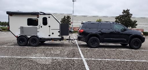
Run planned for this summer. Saint Stephan to Hopewell Rocks.

  • HTML tutorial

RJ Howell

Rank V
Launch Member

Influencer II

1,958
Auburn, NH USA
First Name
RJ
Last Name
Howell
Member #

22834

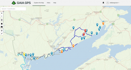
This will be byways (paved), dirt and occasional 2 track, or so is the plan. The entire run could very well be 400-500 miles of roadway/trail. I'm still working on the Route planning and hoping to gain some assistance on parts of the route and suggested changes.

I'll be running my F150 4x4 up there, if indeed I have the camper back done. My rig is a overlander, not a off-roader. Minor lift, suspension upgrades and 34's for tires.

Here's the basic run plotted out.

Screen Shot 2020-02-10 at 8.34.09 AM.png
 

RJ Howell

Rank V
Launch Member

Influencer II

1,958
Auburn, NH USA
First Name
RJ
Last Name
Howell
Member #

22834

South of Saint George and east of Black Harbor is Foleys Cove. There seems to be two roads named Foleys Cove Road and a possible connector (through the woods). Anyone familiar with this road/area?
 
  • Like
Reactions: Road

GreyMudder

Rank III
Launch Member

Enthusiast III

646
Saint-Louis de Kent, NB, Canada
First Name
Rino
Last Name
Granito
Member #

22050

Well we are moving from Montreal to NB Saint-louis de Kent in early summer. Would love to join .. I have a Toyota landcruiser 1997. What time frame are you looking at ?
 

RJ Howell

Rank V
Launch Member

Influencer II

1,958
Auburn, NH USA
First Name
RJ
Last Name
Howell
Member #

22834

Well we are moving from Montreal to NB Saint-louis de Kent in early summer. Would love to join .. I have a Toyota landcruiser 1997. What time frame are you looking at ?
I'll post up as we get closer to it. My hope is to have the truck camper built for the run (even if just shell and weather tight). End of May we're with family in SD, so earliest would probably be late June/early July.

I've been up in the Saint-Louis de Kent area when we did our Nor'east Maritime run. Interesting area, yet sorry to say... I liked the northern stretch better. Arcadian Isles and over Gaspe. Once settled in there, you'll have to tell us all about that area and places to ride!

The route is constantly being updated as more folks pass info back to me. St Stephan to St John is pretty much byways, yet paved. Not much has changed on that one (many a few more possible over-nights). The Upper run St John to Hopewell is still a work in progress. This route does get on dirt & 2 track roads. Some of which are open, yet finding a few are in&outs...

I'll post up the latest .gpx soon.
 

GreyMudder

Rank III
Launch Member

Enthusiast III

646
Saint-Louis de Kent, NB, Canada
First Name
Rino
Last Name
Granito
Member #

22050

Sounds like an interesting trip. For Saint Louis de Kent this is our retirement home. But we love wheeling. If I can get enough info would love to plan some eastern rides. I also enjoy Nova Scotia and wheeled there in the 90s . Now to see if I can gfind my old topo maps. nothing like ol Skool ;-)
 

RJ Howell

Rank V
Launch Member

Influencer II

1,958
Auburn, NH USA
First Name
RJ
Last Name
Howell
Member #

22834

Sounds like an interesting trip. For Saint Louis de Kent this is our retirement home. But we love wheeling. If I can get enough info would love to plan some eastern rides. I also enjoy Nova Scotia and wheeled there in the 90s . Now to see if I can gfind my old topo maps. nothing like ol Skool ;-)
I've truly embraced technology! I learning Gaia GPS and with this Backroads Canada it just shows so much info. I think I still have some maps around here... LOL

Our first retirement run was the Maritime Run and very much enjoyed it ! I felt we ran through lower NB to quick and this run is to fix that!

I haven't done much inland NS. I've run most of the coastline and did find some rather interesting spots. One short run through the interior showed me that there was much more to be explored there!

With Gaspe north of you and cross the St Lawrence and run up to Kegashka along the coast.. Oh My! You have some very interesting places to explore! We Crossed Matane to Godbout and went south. To this day I'm sorry I didn't turn right and went up that coastline!
 

GreyMudder

Rank III
Launch Member

Enthusiast III

646
Saint-Louis de Kent, NB, Canada
First Name
Rino
Last Name
Granito
Member #

22050

I've truly embraced technology! I learning Gaia GPS and with this Backroads Canada it just shows so much info. I think I still have some maps around here... LOL

Our first retirement run was the Maritime Run and very much enjoyed it ! I felt we ran through lower NB to quick and this run is to fix that!

I haven't done much inland NS. I've run most of the coastline and did find some rather interesting spots. One short run through the interior showed me that there was much more to be explored there!

With Gaspe north of you and cross the St Lawrence and run up to Kegashka along the coast.. Oh My! You have some very interesting places to explore! We Crossed Matane to Godbout and went south. To this day I'm sorry I didn't turn right and went up that coastline!
Yes we are very excited to go explore. Also looking for good people to go wheelin. I have looked at Gaia, but not sure how to get the right topos and document my runs. Usually we explore and trace . I have a free version but with the online map I really do not see anything. And how why I import a gpx into the online without first having a local map..

Sorry bout the rant.. :-( But really looking forward, plus we are starting a small vblog (GreyMudder) to help retired folks join the folds of overlanding, I feel that our gen has been excluded from this activity.
 

RJ Howell

Rank V
Launch Member

Influencer II

1,958
Auburn, NH USA
First Name
RJ
Last Name
Howell
Member #

22834

Yes we are very excited to go explore. Also looking for good people to go wheelin. I have looked at Gaia, but not sure how to get the right topos and document my runs. Usually we explore and trace . I have a free version but with the online map I really do not see anything. And how why I import a gpx into the online without first having a local map..

Sorry bout the rant.. :-( But really looking forward, plus we are starting a small vblog (GreyMudder) to help retired folks join the folds of overlanding, I feel that our gen has been excluded from this activity.
You can load the .gpx file into Google Maps as well. That way you can still view and look around a bit. I went Gaia Pro ($$) mainly to get Canada Backroads Mapbooks. Several other features come along with Pro (mainly USA based) that I really like.

New Brunswick has it's own site as well. This site gives you land ownership which really helps in finding Queen's Land or something you could freely wheel on.
GeoNB - information about all things "geographic" in New Brunswick
 
  • Like
Reactions: SPRINTERAE86

SPRINTERAE86

Rank I
Launch Member

Contributor I

233
Angus Drive, Charlottetown, Prince Edward Island C1C 1H7, Canada
First Name
Ian
Last Name
Aguila
Member #

22155

I have grand hopes of going up next year... If we're allowed by then..
Where would you suggest a good place to camp in PEI? I'm planning on doing nights of camping after my 14 day quarantine.

I'm not sure what the protocol for leaving and returning to the island yet. I will just have to stay in the island until I get my permanent residence status updated.
 

RJ Howell

Rank V
Launch Member

Influencer II

1,958
Auburn, NH USA
First Name
RJ
Last Name
Howell
Member #

22834

Where would you suggest a good place to camp in PEI? I'm planning on doing nights of camping after my 14 day quarantine.

I'm not sure what the protocol for leaving and returning to the island yet. I will just have to stay in the island until I get my permanent residence status updated.
I stayed at two commercial CG's on the east coast & north shore, then boondocks a bit west side and south shore. Seal Cove on the east side, just up from the ferry terminal, was a great start. Also Bayside CG on the Northshore. iOverlander does a pretty good job on showing commercial and free locations.

Only 12% of PEI is public lands. And of that maybe half is free to camp on. I really didn't bother much with it. PEI Public Lands Map will show you where they are, but you'll have to dig deeper if you can camp there.

I loved PEI!! Awesome people up there (locals that is). Most places we stayed for free, we just asked and most said "Yes".
 

Enthusiast III

1,212
Grand Falls-Windsor, NL, Canada
First Name
Steve
Last Name
Adams
Where would you suggest a good place to camp in PEI? I'm planning on doing nights of camping after my 14 day quarantine.

I'm not sure what the protocol for leaving and returning to the island yet. I will just have to stay in the island until I get my permanent residence status updated.
We have whats called the atlantic bubble right now, after your 14 days, and you are virus free you are free to roam PEI, NS NB and NF. Enjoy GODS COUNTRY!

EDIT: Don't forget your masks, they are madatory in all public indoor places in atlantic canada. Hence the reason we are keeping control of the virus on this side of the coin.
 

SPRINTERAE86

Rank I
Launch Member

Contributor I

233
Angus Drive, Charlottetown, Prince Edward Island C1C 1H7, Canada
First Name
Ian
Last Name
Aguila
Member #

22155

Thank you.

I'm in my day 7 of my 14 day. I was tested Wednesday and was negative. I'll have another test Friday.

Yes, mask in all public indoor places. A lot of people where I came from do not follow that protocol. Hence one of the reason we decided to move to PEI. And also to be closer to the in-laws who's in their late 80's.
 

Enthusiast III

1,212
Grand Falls-Windsor, NL, Canada
First Name
Steve
Last Name
Adams
Thank you.

I'm in my day 7 of my 14 day. I was tested Wednesday and was negative. I'll have another test Friday.

Yes, mask in all public indoor places. A lot of people where I came from do not follow that protocol. Hence one of the reason we decided to move to PEI. And also to be closer to the in-laws who's in their late 80's.
Yeah it's a shit show down there. Welcome to Canada.
 
  • Like
Reactions: SPRINTERAE86