Plumas NF BDT (Back Then...)

  • HTML tutorial

Ashton

Rank IV

Pathfinder I

1,212
Near the Rubicon
First Name
Hari
Last Name
See Above
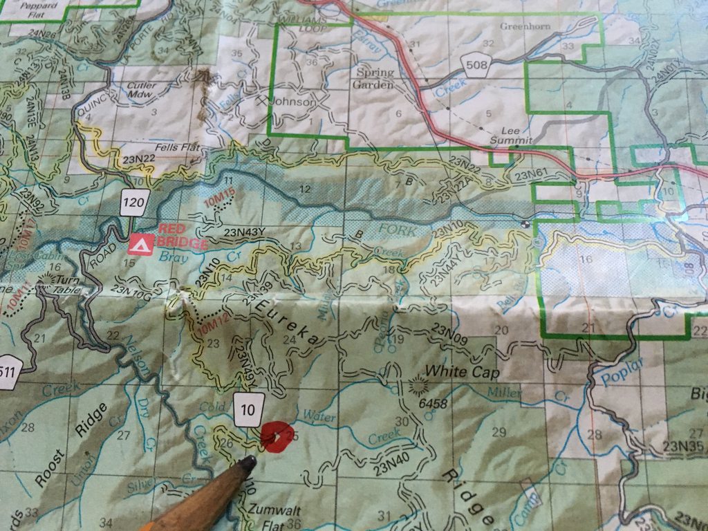
The directions on our PDF in post 1 were pretty spot on in terms of where to steer the vessel port and starboard. There was a few times when a 'bear left' was incorrect, in that there was no bear on the left AND the road that went left was closed. I will say that the path forward is pretty clear, the road more traveled is the road to follow in times of question. Also, the markers for the route are present at most (if not all) major questionable intersections and we were able to locate them on all but a few spots of mention.

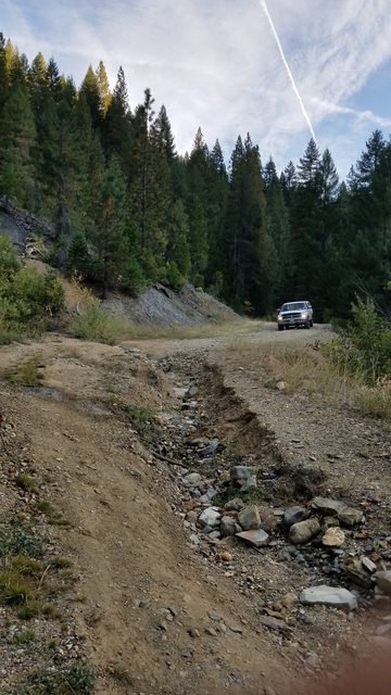
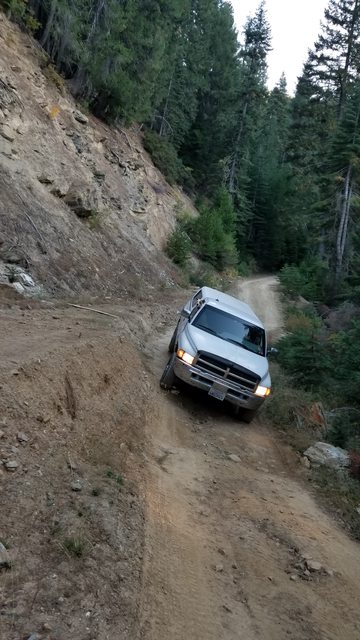
Fallen trees were a theme on this trip. Most had met the chain saw and the road was clear, but several were leaning low across the road. Serenity is a wide rig and stands fairly tall on her 29" wheels and several of the trees came in proximity of our CB antennae. A couple of times I had the co pilot guide us through the highest point, so as to not pull it off its magmount.


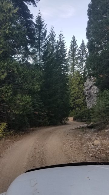
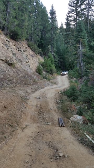
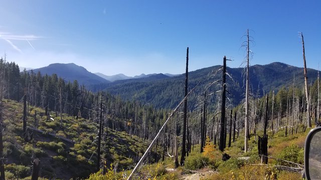
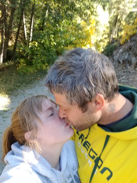
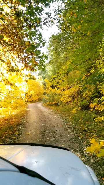
The trail is relatively easy and there are only a couple of sections requiring of real focus and attention. We moved the rig along at a stately pace with the intention of camping overnight at Harrison Flat, about 8 miles from the PCT junction. The sun was headed for the western horizon and long shadows were beginning to occupy portions of the road that I needed to see to steer the vessel correctly. The scenery was a distraction too, so i'll quiet down now and let you enjoy vicariously. These are in no particular order.


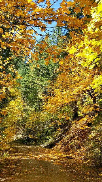
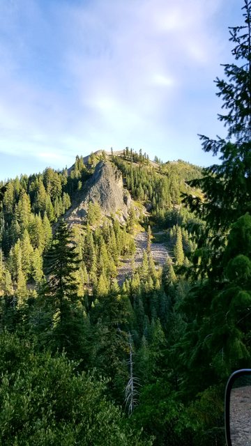
For a bit there, we seemed to round a corner and hit a view of a new peak. I've traveled the road through Banff National Park in Alberta and I won't begin to compare the two drives, but I did get a similar tingle in me loins when I made the emotional connection to the majesty of nature.


As you near the 12 mile mark (11.8 on our odometer) you will come upon a dead tree on your left. That is not uncommon in a forest, in and of itself, but it is not mentioned on PDF in post 1, and I think it should be. A tree this large is clearly old and a landmark in its own right. It also frames a great view -not the best on the trip, but one worth mentioning. I will mention it, and include it in my report for the sake of future expeditions of the region.


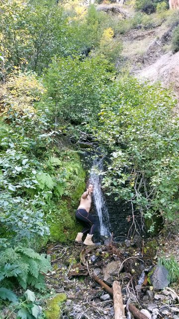
On down the road towards Harrison Flat and you will cross creeks named after the range (Bunker Hill) and Sherman and Hopkins. You will pass a Turkeytown Diggings, which looks like most of the other diggings on this trail, a white slab against a green backdrop draped in a blue sky. While we made tracks to Harrison Flat and we jammed the comedy stylings of Mitch Hedburg on the Kenwood and I found myself lost in the clean crisp scent of evening in the wild. The cool air tickled the hairs on my arm, casually laid out the downed porthole on my vessel. I could spend my life like this, I know this to be a fact. I would just get lost...


Getting lost is nice and well, but we had the most difficult section of this adventure coming up and we were in for a real test of our skills developed in the years and months before our undertaking of this adventure. Stay tuned my friends, day 2 of the Plumas Backcountry Discovery Trail Part 1 and 2 continues!
 
Last edited:

Ashton

Rank IV

Pathfinder I

1,212
Near the Rubicon
First Name
Hari
Last Name
See Above
The ∩OV Serenity was cruising comfortably, with the sub-infinity drive set to 4 high and engaged in second gear. Our ears were comfortable and being entertained with comedy routines that had us laughing out loud. Our eyes took in the new sights, processing the information into electrical signals and sending those to the back of our brains. Our noses prickled at the clean fresh scents of nature and the cool breezes that were kicking in the lower canyons on this evening. We were content and knew we were in the right place, and we didn't need maps or a GPS to tell us so.

We are on the black and white checkered, following terrain contours at a fairly even altitude. We crossed a few creeks, ate some snacks and had a beer, and kept the jovial spirits flowing.


There is a mention of a waterfall on your left in the PDF from post 1. We thought this might be it, but we came across another more spectacular waterfall later down the road, closer to the coordinates (though beyond the indicated mileage, not an uncommon occurrence on this expedition).


I'm a playful tiger.


There was evidence of the other main industry that this area has supported for centuries. Piles of felled timber, most of it looking weathered beyond normal drying times, dotted the sides of the road and clearings in the woods along the route.


As we rounded a bend and apporached mile thirteen, we saw a marker on the PDF - "As you round the corner, look for a twisted pine growing out of the rocks.". I personally thought they meant the large pine I showed pictures of and claimed isn't on the PDF earlier. We assumed they must have meant this one, as it is on the right and we have learned to trust the PDF. There was also examples of columnar jointing, the process of basalt cracking when hot magma cools unevenly. This is a cool phenomenon and I personally get excited driving by the carved hillsides on interstates. Seeing the deeper layers of rock, presumably older layers of rock, stimulates that same sense of wonder and curiosity about the history that I've been struck with often on this journey. The process that creates this seems an active and forceful one and I can imagine it in my mind as if I was staring at the flames of a camp fire.
 
Last edited:

Ashton

Rank IV

Pathfinder I

1,212
Near the Rubicon
First Name
Hari
Last Name
See Above
All along the route the downed trees and small landslides showed us that the previous winter had left its mark on the area and when approaching Harrison Flat the road showed signs of the ravages of the winter of 2016/17. Down in Grass Valley and Nevada City we got lots of wet rain and snow, something we hadn't seen in years. It washed away roads and created an alteration in the landscape in the forest. This area was no different, and we had to traverse some of the remnants of that destruction.


Our navigational instruments showed us that we were approaching the sixteen mile mark of todays journey, and the PDF guide in post 1 told us we would see a giant boulder. With little else to identify our target and with no lack of large rocks to take pictures of, we determined one of these landmarks to be the one indicated on the document.


We saw continued signs of the alterations natures forces had made on the route, with landslides both large and small abundant in this portion of the trail. We came across one such slide that was on a epic scale, probably several hundred yards of earth slid downhill here and the road was remade to cross the section. While not technical, it was a test of our communication and our line identification as my co pilot navigated me by radio comms through the tight channel. Our vessel emerged unscathed and we celebrated our accomplishment. This was our first real road challenge in the Serenity in a unsupported and unfamiliar area. Those of you who have traveled and traversed know the thrill and sense of adventure we both felt at the time. I do wish I had in cab video to show you of the traverse, as it was way off camber, narrow and had some precarious dips (one bringing my arm and head within a foot of a very large rock.. or what seemed to be that distance anyhow).


It weren't long before we coasted down into Harrison Flat and the dispersed camping we sought as refuge for the night. It would not be had there, as someone had set up a semi-permanent encampment at the site and had a vocal dog. Not wanting to be a bother and not wanting to agitate our own furry companion and head of security, we ventured on, consulting maps and Topo Maps+ to find a suitable location for the evening. We pressed on in search of rest and recovery.


  • Like
Reactions: CTO1Mike

Ashton

Rank IV

Pathfinder I

1,212
Near the Rubicon
First Name
Hari
Last Name
See Above
I have neglected the history of this leg of the journey because it is much of the same repetitive stories of miners finding claims and others coming to partake. These gatherings created hamlets all over the landscape and all but a small handful remain as outposts of humanity. I also leave it to you, oh curious adventurer, to find and learn the knowledge that sparks your curiosity. I only hope to provide the flint and steel.

We left the scene at Harrison Flat and checked the shotgun to ensure its accessibility. We had felt somewhat uncomfortable with some of the other local folk we had come across - their eyes darting around what view of the bridge they had and their expressions mostly slack-jawed when we told them our intentions for this journey. I am rarely uncomfortable out in the back country by myself, though I have many years of training and testing of my skills in weapons and self defense. The dis-ease that my co pilot felt meant a thing to me and I sought to calm it with my reassuring manhood.

The road continues on to Nelson Creek. We were onto the official portion of stage two of the map of the Plumas BDT, and it was approaching dark. We wanted to find a suitable berth for the ∩OV Serenity tonight and were anxious to get there before all darkness settled in. The sense of exploration and abundance of stops for photo ops changed into a need based search of all cubbies, pull outs and turn offs that we approached.


See the marker and know you are on the right path traveler. You shall not be led astray.


There was scenic views all around us as the landscape opened up and we steadily climbed in altitude. We passed a bit more geological examples of columnar jointing and entered into a burned out area of regrowth. In 2008, the Cold Fire raged here and along Cold Water Creek and burned more than 5500 acres in 15 days (a small fire by some comparisons). The change was drastic, as we had spent the entire day in the evergreen forests, with sky above but not around us. We came upon a landscape open and soaking in the last rays of daylight, which lit up the maples and aspens that had begun to take over the hillsides in amazing displays of color.


A handful of miles past Harrison Flat, we came down a hill and rounded a bend to climb another. At this point our maps indicated we were on Cold Water Creek. Here the road hugs a hillside and the squeezes through brush, all the time presenting open hillsides with more color than we were used to seeing on this trip. Eventually, the road crosses a large drainage with a stream on either side. Our maps indicated this was Cold Water Creek and our PDF mentions that the road doubles back along that creek, so we judged our location to be accurate. There is two dispersed camping sites at this location and we chose the one just off the road. We were close to the rushing water all night and thankfully we had no traffic on the road that night, save the two young hunters in a jeep that ambled by just as we were scouting the location for a camp site. They also gave us an uneasy feeling and we were glad for the security of a warm dinner in the back of the rig.


Darkness settled in and we took to our funny shows and a game of gin (or rummy, we weren't sure at the time and found out later it was neither!). A couple of doses of hooch and a puff or two of the ol' wacky leaf and we were headed quickly for the bliss of slumber in the wild. One last picture of the incredible star display on Shauna's Samsung S8. This ended our second day on the Plumas Backcountry Discovery Trail and we rested on a deep sense of accomplishment and relief. We saw the finish line of this expedition and we knew our crew had what it took to achieve it.

Tomorrow starts day 3 of the journey, stay tuned!
 
  • Like
Reactions: CTO1Mike

Ashton

Rank IV

Pathfinder I

1,212
Near the Rubicon
First Name
Hari
Last Name
See Above
I'll post day 3 in a couple hours. Just finishing up work. Already planning the finale of this route for this summer/fall.
 

Ashton

Rank IV

Pathfinder I

1,212
Near the Rubicon
First Name
Hari
Last Name
See Above
Day 3. Finally!! upload_2018-5-13_23-20-15.gif

The first two stages of the Plumas Backcountry Discovery Trail are intended to be ran together, on the same day. Due to our reduced pace of travel and the general jovial nature of this expedition, we had turned the first two stages and the alternative 4x4 route from La Porte to Poker Flat into a 3 day expedition. We had learned much about the history of the area - rife with those who would scour the land for it's riches, and those who sought it's bounties for kingdoms all in an area that had been occupied by a Native culture who lived close to the land and with a deep respect for it. The scenery had been amazing, the history had been colorful and tangible and the excitement we had for nearing the completion of this trip was energizing.

We stayed the night at this spot on Cold Water Creek. It was cold and windy but we slept more soundly and comfortably than we had at the RV parking lot the night before. We had arrived just around dark, and had a good idea of the landscape. We enjoyed the scene when we climbed off the tailgate in the morning too, and were thankful we didn't have any bear or cat visitors that night (or rattlesnake - evidently there was one living under the solar powered light which illuminated the claim tag for this portion of the creek. A friendly warning to mind the snake is written into the post.).


The morning constitutionals were done with spectacular views and cool breezes on the backsides.


We continued climbing on up the Eureka Ridge heading north and east towards the end of our adventure. We spent this day enjoying the scenery and the beauty of the day. We had spent the last two days focused on absorbing and learning and today we chose to experience. We saw some magnificent views, including a plume off of the Eureka Fire (we assumed), which is a controlled burn that has been going on since September. This was the only indication that we had of the catastrophe that took place last night and this morning in parts of Sonoma and Napa County. God bless those who lost their lives and I pray that the ones who didn't are keenly aware of the preparations they need to be safe and secure in times of immediate danger.

The scenery around us for a bit..


  • Like
Reactions: CTO1Mike

Ashton

Rank IV

Pathfinder I

1,212
Near the Rubicon
First Name
Hari
Last Name
See Above
The road on this side of Harrison Flat is a bit smoother and a few less opportunities for pin-striping exist along the route. There were still small washouts, which Serenity skirted over with ease. I was proud of my vessel on this journey. She felt strong and capable and did all that I asked of her. She complained very little and operated at peak performance. Her crew is capable and dependable, and darn beautiful.

My lovely co pilot/navigator and our furry head of security.


Parts of the road are still in disrepair. They were not extreme, but I wouldn't want to be a passenger vehicle going over these, so stick to the high clearance vehicles and you won't have any problems either. Overall the road was open, easily passable and comfortable to drive.


We passed in and out of pine and fir forests, and spent some time driving through maples and aspens that hugged the road and gave it a flavor that was unique to this expedition thus far. I think this was my favorite driving day, and made for a fine finale.


We stopped at a creek, whose name I didn't bother to look up. We had attempted to make hot pockets, wrapped in tin foil, on the exhaust manifold. Perhaps the only fault of ∩OV Serenity is that her engine does not run real hot, unless I'm pushing her hard. We had been traveling for about an hour and we only had warm pockets. We stopped to try or attempt at overland baking and turned it into an impromptu photo shoot.


Enough of the cute crap.


Dutch Bros, we expect royalties for this product placement.
 
  • Like
Reactions: CTO1Mike

Ashton

Rank IV

Pathfinder I

1,212
Near the Rubicon
First Name
Hari
Last Name
See Above
Several of todays miles were spent in a oddly colorful landscape. The season was right, but the longitude felt wrong. I've not seen such a dominance of deciduous trees in this part of Northern California and I was taken back to my childhood in Massachusetts. Memories of riding my yellow and blue huffy down wandering country lanes on the way to the bowling alley, to play video games and buy candy out of the vending machine. This was the weekly ritual of allowance day and I was pleased to relive these happy feelings for the first time in a long time.


We crossed a few creeks and several brooks along the last few miles of the journey. Eventually we would cross the middle fork of the Feather River (Rio de las Plumas, as the Spanish explorer Arguello dubbed it). I was enjoying the journey my mind was taking while we maintained cruising speed in Serenity. In 1850, James Beckwourth discovered the lowest altitude pass through the Sierras and that helped fuel the boom of settlers and gold seekers. I was imagining myself as one of those early prospectors, hopeful for riches and excited by the new land around me.


We saw this interesting placard on a tree on the way out. There was several parcels of land that were designated private property of various hunting and sportsman clubs, this was the most unique I saw.


As you near county road 509, and the end of this portion of the Plumas BDT, you will enter a valley and cross the middle fork of the Feather River. The terrain has opened up at this point and you are in an area appropriately called Long Valley. There is a sign board for information on the Eureka fire and some mileage signs for various destinations in the National Forest.


Trust the markers traveler, they will guide you true. When stormy waters send you astray, discover the path with these indicators and thou shalt be saved. 23N10 is the longest traversed road on this, the first two portions of the Plumas BDT.


Shauna has a collection of these and sometimes surprises me at how well she stays behind the scenes. I rarely notice her noticing me noticing things.
 
  • Like
Reactions: AprilC and CTO1Mike

Ashton

Rank IV

Pathfinder I

1,212
Near the Rubicon
First Name
Hari
Last Name
See Above
Continuing the theme of the Plumas Backcountry Discovery Trail there was a small community located at the intersection of 23n10 and road 509. The town is named Sloat and was named in 1910, after Commodore John Drake Sloat, Commander-in-chief of the Pacific Fleet in the Mexican-American war. He is credited with claiming California for the United States, though there is (as there usually is) disagreement about these things.

Comm. Sloat's declaration to the people of California - DMWV.ORG - A proclamation

A document about the history of the Mexican-American war which mentions the challenge by those involved in the "bear flag revolt" of 1846. I personally think these two events are likely linked, with the government using these separatists (Mexican authority ruled the day) and their struggle as pretext. - The Acquisition of California


After crossing the train tracks, we turned left on to 509 and headed towards highway 70, and the relaxing solace of a hot springs soak before pointing our vessel towards her home port. Once arriving at highway 70 a couple of miles later, we turned right and were shortly greeted by the sight of a BBQ place on the left hand side of the road. Neighbors BBQ looked inviting and we found that we were instantly hungry. We had arrived minutes after their official opening time and the wonderful lady was happy to seat us and serve us. The food was delicious, likely enhanced by the ecstasy and high we were on from completing our intended mission. We had entered an unknown environment and came out on the other side in far better shape than we expected. We soaked in the warm sunshine and dog friendly atmosphere and enjoyed a beverage and a meal. EXCEPTIONALLY well priced for the quality of food and service we got. I HIGHLY recommend them, and my google review stands testament. There is cell signal here and, more importantly, free wireless. They also have a parking spot area and dumpster that looked boondocking friendly. I did not ask about it, but I wouldn't be afraid too.


The placement of this award was... interesting. Amateur Right Hand Champions trophy for the 177-198 weight class. I had a chance to read the plaque as I was talking to a man about a horse.
 
  • Like
Reactions: CTO1Mike

Ashton

Rank IV

Pathfinder I

1,212
Near the Rubicon
First Name
Hari
Last Name
See Above
Your ever ready and faithful Captain, swooning over the memories of the past days spent with my wonderful companion and our fur baby. I really did have an exceptional time at this and my crew and vessel made me incredibly proud. I fear my confidence to complete any mission assigned to us may test our abilities, but what else is a Captain for if not to motivate crew and overcome challenges?


My lovely co-pilot. We had not used our electronics to communicate with the outside world, in what felt like months, so we did spend several minutes catching up to all the dings and whistles of our Googleometer alerts.


Our beautiful Indica is an amazing road dog, even though she hates being cooped up and would rather run a lot and see whats to be seen. She is the least experienced of the crew and will need time to develop the understanding of nature and her limitations.


After a gluttonous meal which we enjoyed with ravish enthusiasm, we headed to Sierraville Hot Springs and a well deserved soak in the (clothing optional!) natural sulfur hot springs that feed their pools. I did not opt for the massage and spa treatment, which I should have. The directions available in multiple locations to this place are accurate and so I won't provide a long description, other than to say it is in Sierraville, CA. No cameras or phones are allowed, because this is a clothing optional members retreat (they offer public access, camping and RV spots and a dorm style main house as well as a historical hotel in town).


We spent a few hours washing the road grime from our skin and relaxed our tired muscles. With the soft skin and subtle stank of sulfur, we headed back down slope towards our home port. Indica sensed this change in direction and as we neared more familiar territory, she seemed pleased with the overall success of the adventure.


It wasn't until we exited I80 on to hwy 20 that we got any indication of the disaster which occurred that morning. We came down on an incredible scene of a landscape covered in smoke and a muddy red sunlight that looked like an alien planet. We are familiar with smoke from forest fires and we knew immediately what we saw. This was a extremely stark contrast to the environment we woke up in and had enjoyed just miles before. The sun disappeared behind the haze and the blue sky turned soot grey. After docking safely with all souls on board, we learned the extent of the damage across the state and were saddened slightly. Large swaths of California were on fire, some were incredibly local and affected people we personally knew. God bless all those who were affected.


We had completed the goal we set for ourselves and had several unintended adventures along the way. This is one of the beautiful things about overlanding, four wheeling or just generally getting out into the world. Whether urban or remote, you find adventures and see things you otherwise wouldn't and confront situations and experiences which provide growth as a human being. The benefits of these expeditions last long after we return to our obligations to society and take up our places in the economic wheel. Our spirits are lightened of their stress and burdens, we have increased confidence in our abilities and our selves and we have recharged those energy packs that deplete when one doesn't reconnect with nature for a time. We were thankful and felt blessed, and look forward to the next portion of the Plumas Backcountry Discovery Route that we tackle. Till then, thanks for tuning in and giving this book a read and as always, remember to stay ∩northdox.
 

Ashton

Rank IV

Pathfinder I

1,212
Near the Rubicon
First Name
Hari
Last Name
See Above
Thanks for reading everyone! Hope you have enjoyed reading my book of the journey along the start of the Plumas National Forest Back-country Discovery Route. Tune in to future adventures, as we finish up this passage and explore some of the other historical trails and byways in Northern California, and beyond! :cheers:
 
Last edited:
  • Like
Reactions: JCWages

JCWages

Rank V
Launch Member

Pathfinder I

2,271
Grass Valley, CA, USA
First Name
Justin
Last Name
Wages
Member #

18693

Thanks for posting or reposting. Well worth the read. I appreciate the level of detail and history with included links.
 
  • Like
Reactions: Ashton

Ashton

Rank IV

Pathfinder I

1,212
Near the Rubicon
First Name
Hari
Last Name
See Above
Thanks for posting or reposting. Well worth the read. I appreciate the level of detail and history with included links.
Thanks for the read!! I know that I write a bit long sometimes and I love including pictures for the thousands of words they tell, so i'm thankful when people go through it and enjoy.

I have another trip report to post, been a bit lazy since I got home from vacation.
 

AprilC

Rank V
Launch Member

Enthusiast III

2,239
Rocklin, CA
Member #

10754

Did you go in May or post later on? I’m just wondering because I’d love to go when the leaves are the same color. Man it reminds me of where I was born.
 

JCWages

Rank V
Launch Member

Pathfinder I

2,271
Grass Valley, CA, USA
First Name
Justin
Last Name
Wages
Member #

18693

Did you go in May or post later on? I’m just wondering because I’d love to go when the leaves are the same color. Man it reminds me of where I was born.
Those are big leaf maples. Their leaves change sometime in September/October usually depending on location. He referrenced the Tubbs fire in Sonoma so that puts his trip in early October.
 
  • Like
Reactions: Ashton

Ashton

Rank IV

Pathfinder I

1,212
Near the Rubicon
First Name
Hari
Last Name
See Above
I need this in my life today! This is so pretty! This reminds me of MA too, my home state.
I actually grew up for a time in Millis, MA and parts of this drive reminded me of the woods I played in as a kid. And yea, this was early October. Great time for it, though I think the spring would be nicer in terms of flowers.
 
  • Like
Reactions: JCWages