Out of Yuma AZ going east

  • HTML tutorial

RJ Howell

Rank V
Launch Member

Influencer II

1,958
Auburn, NH USA
First Name
RJ
Last Name
Howell
Member #

22834

I learned I can drive through the Yuma Proving Grounds at least along the AZPT. Now I'm hoping to learn if I can do the same on the Barry Goldwater Range. Hoping to dirt road Yuma to Organ Pipe.

Screen Shot 2020-10-27 at 10.39.57 AM.png
 
  • Like
Reactions: Offroadnutz

RJ Howell

Rank V
Launch Member

Influencer II

1,958
Auburn, NH USA
First Name
RJ
Last Name
Howell
Member #

22834

Looking a lot like running Rt85 to Organ Pipe. The area looks like something not to be passed up.. so be it. I may still try while down there and work a route, but I have a feeling Rt85 may be it.

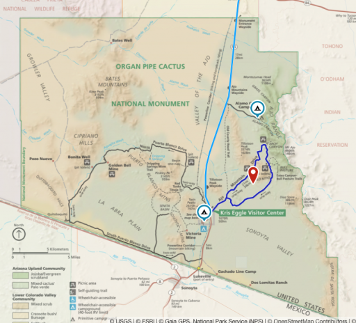
What can you tell me of Organ Pipe Catus NM ? I see two scenic routes down there and two CG's. I like that Alamo CG. I figure it's camping only in those CG's, so How crowded does it get Jan/Feb?

Screen Shot 2020-10-28 at 8.34.25 AM.png
 

USStrongman

Rank V

Influencer II

1,596
Lubbock, TX, USA
First Name
Bryan
Last Name
Hildebrand
Member #

20099

It gets chilly down there considering it reaches 4,800' elevation. Have never done that route. I've done a lot of stuff east of there in Tombstone/Bisbee out to the the NM border. No one out there but a few illegals and border patrol in Jan/Feb, but again, it gets pretty chilly due to elevation. Bisbee alone is 5,600'. I lvoe southern Az in the winter. Quiet, great all day sun, cold mornings. So many trails all around the state.
 
  • Like
Reactions: RJ Howell

RJ Howell

Rank V
Launch Member

Influencer II

1,958
Auburn, NH USA
First Name
RJ
Last Name
Howell
Member #

22834

Well, I have jumped to the other side of Tucson and getting a bit overwhelmed... Have a look at this proposed route and let me know any thoughts on it. Seems I'm gaining some elevation in areas through here and not really much for dirt routes, that I can find...

Screen Shot 2020-10-29 at 3.18.25 PM.png
 

USStrongman

Rank V

Influencer II

1,596
Lubbock, TX, USA
First Name
Bryan
Last Name
Hildebrand
Member #

20099

Very little becomes impassable in the winter unless it rains. Silt based mud is the enemy. While there are not a lot of direct off-road routes, there are a ton of trails in and around Tombstone and Bisbee. In the summer some of them can have some sketchy characters (camping; ie - Breaking Bad) out in the middle of no where. In the winter, not so much. Too cold.

Around Sierra Vista is Fort Huachuca. Busy winter Army base and some interesting topography around.

If heading west on I-10, Between Lordsburg and the AZ border (stop and get fuel), Hwy 80 parallels the NM/AZ border. I love this road. Hardly anyone around on the couple dozen times I have run it except BP trucks. It eventually crosses over from NM to AZ though there is no sign telling you. Cool abandoned mines and houses from the 1800's dot the area. Follow it all the way south and it takes you to the Douglas border crossing. Fuel, Walmart, food are there. About 3 miles from the border, Hwy 80 climbs west through the mountains and tailings from the copper mines that proliferated the area. Gorgeous scenery. Stop in Bisbee for a night. Locals can direct you to the trails N/NW of town. From there head out to Tombstone area for more trails. not a lot is available on maps, but they are out there. I've done them, but it was about 10 years ago.
 
Last edited:

RJ Howell

Rank V
Launch Member

Influencer II

1,958
Auburn, NH USA
First Name
RJ
Last Name
Howell
Member #

22834

Great info coming back! Thank you!

Well, let me push it a bit further because I've figured the Mogollon Rim was out during winter.. I figure that's 7800ft.. Piney Canyon in the Chiricahua Mts. is 6-7K ft.. thought much further south
 

USStrongman

Rank V

Influencer II

1,596
Lubbock, TX, USA
First Name
Bryan
Last Name
Hildebrand
Member #

20099

Northern AZ is far different than southern. Mogollan, Flagstaff, San Francisco's can have closures and most trails can be challenging, depending on that seasons snow.
 
  • Like
Reactions: RJ Howell

RJ Howell

Rank V
Launch Member

Influencer II

1,958
Auburn, NH USA
First Name
RJ
Last Name
Howell
Member #

22834

Northern AZ is far different than southern. Mogollan, Flagstaff, San Francisco's can have closures and most trails can be challenging, depending on that seasons snow.
I can work with elevation, confusing when added to latitude.. When I traveled through there before, it was dealing with altitude. Adding latitude into the mix is weird to me, yet on a level I seem to understand (?).
I've skied Tahoe as Looked down on desert.. ya confused me, smiled and cut a turn. How can I do this and see this at the same time?
Altitude makes sense. Now you're going to add latitude to the equation?

I am loving this! Even with my rant.. loving the info coming back. I'm still putting Mogollon Rim of out the range of this trip... I may take a drive that way, but not expecting it.