Oroville evacuation

  • HTML tutorial

T_Polo

Rank V
Launch Member

Enthusiast III

1,721
Applewood, Lakewood, CO, USA
First Name
Tim
Last Name
Markham
Member #

3755

Service Branch
US Navy (veteran)
I just saw the news about the failure of the Oroville Lake Dam. If any of you OB'ers live in that area, please be safe, help others if you can do safely. My prayers go out to all those effected.
 

BCBrian

Rank V
Launch Member

Advocate III

1,836
Boulder Creek, CA
Member #

3344

OK folks..... let me be perfectly clear about this - IT IS NOT THE DAM FAILING, IT IS THE AUXILIARY SPILLWAY!

This is still a very serious emergency and they are letting water out of the lake using the regular spillway that has a large hole in it (you may have seen this on the news). The auxiliary spillway is on the other side of the main spillway from the dam. They are evacuating 160,000 people from Oroville, Yuba City, Marysville and other towns along the Feather river drainage. If the actual dam were to fail Sacramento would be under water. At 770 ft tall this dam is the tallest in the US and holds back the 2nd largest reservoir in CA.... only Lake Shasta holds more water.

Here is a link to an article and the live updates - http://www.mercurynews.com/2017/02/12/oroville-dam-live-update-spillway-is-in-danger-of-failing/
 

BCBrian

Rank V
Launch Member

Advocate III

1,836
Boulder Creek, CA
Member #

3344

There are large helicopters dropping bags of rocks into a large hole that formed on the auxiliary spillway. This spillway has NEVER had water flow over it before. It is not concrete but just raw earth and a road that crossed it has been washed out. With the huge release of water down the damaged regular spillway, they have reduced the runoff down the auxiliary spillway way down and expect the lake level to drop below the edge of the auxiliary spillway soon.

What a mess! 5 years of drought and then we get slammed repeatedly this year. Santa Cruz County has suffered 100's of MILLIONS of road damage. We had a worker backed over by a dump truck on Hwy 17. Many roads are closed indefinitely and more rain is forecast starting thu.
 

T_Polo

Rank V
Launch Member

Enthusiast III

1,721
Applewood, Lakewood, CO, USA
First Name
Tim
Last Name
Markham
Member #

3755

Service Branch
US Navy (veteran)
I apologise. My Mom turned on Accuweather, and we caught their report of the incident. Their report made it seem like the auxiliary spillway was being used because the main dam had failed, then evacuations had been ordered because the aux spillway was damaged as well. Though, they did report that the aux spillway had never been used. So, they got one thing right.

Regardless, I experienced part of the "Hundred Year Flood" in Colorado in 2013; therefore my prayers will continue to be with all those affected.
 

luchaDor

Rank VI
Launch Member
Member

Pioneer II

3,774
Urbandale, IA 50323, USA
First Name
Doran
Last Name
Else
Member #

2879

I don't feel you have anything to apologize for...there was certainly no need for all caps & underlining, ie. yelling at you. Especially considering your post was simply calling attention to any OB'ers (and regular folks) that might be scrambling to get out of there.
 

T_Polo

Rank V
Launch Member

Enthusiast III

1,721
Applewood, Lakewood, CO, USA
First Name
Tim
Last Name
Markham
Member #

3755

Service Branch
US Navy (veteran)
I don't feel you have anything to apologize for...there was certainly no need for all caps & underlining, ie. yelling at you. Especially considering your post was simply calling attention to any OB'ers (and regular folks) that might be scrambling to get out of there.
Thank you for that. I did forget to mention the regular folks (oops) but I'm not sure how many of them would be on the forum anyhow. However, all persons affected are in my thoughts and prayers.
 

T_Polo

Rank V
Launch Member

Enthusiast III

1,721
Applewood, Lakewood, CO, USA
First Name
Tim
Last Name
Markham
Member #

3755

Service Branch
US Navy (veteran)
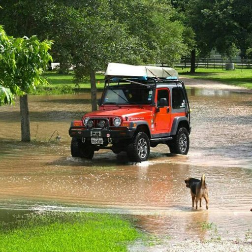
As someone who was part of the Hundred Year Flood of the Brazos River last summer as Texas got flooded, my prayers go out.

Here's the Brazos River in my yard
Sent from my SM-G935V using OB Talk mobile app
I don't have any pic from the Colorado flood. Regardless, it was pretty insane. The areas affected were utilizing snow plows to push mud and other debris of the roads.
 

Cottonwoody

US West Region Member Rep
Launch Member

Influencer II

2,808
Redding CA
First Name
Scott
Last Name
Johnson
Member #

3457

I live in Cottonwood which is about an hour's north of Oroville. The local news up here is inundated with news and updates about the goings-on. The thing that got my attention was that after the spillway breached, a hole opened up below it and was Hydro in back in the direction of the damn according to one of the engineers. Apparently that had stopped but it was a concern at the time. The Sacramento River up here is very high and we are scheduled to have more rain coming up the middle of this week through all of next week.

Sent from my XT1254 using OB Talk mobile app
 

luchaDor

Rank VI
Launch Member
Member

Pioneer II

3,774
Urbandale, IA 50323, USA
First Name
Doran
Last Name
Else
Member #

2879

The funny thing is that I lived in Pleasanton, San Ramon, and finally out in Tracy for a couple of years. I had no idea until I left CA all the waterways around me when I lived out there. Or how accessible the Mtn's were until I started snowboarding up in Bear Valley my last winter out there. I'm sure there is a lot of water stored up in the mountains to feed all the canals...got it hold it back somehow. Too bad it takes a disaster (or hopefully just a close call) to decide to fix something. I was in the TC's when the I-35 bridge collapsed...that was a ticking time bomb...always thought the old bridge looked shoddy. Hopefully they can draw down the water enough to prevent it going over the top again later on.

I bet traffic is a mess for you right now as folks just try to land somewhere!
 

RaggedViking

Rank V
Launch Member

Advocate II

2,528
Readsboro, VT
Member #

2183

I don't feel you have anything to apologize for...there was certainly no need for all caps & underlining, ie. yelling at you. Especially considering your post was simply calling attention to any OB'ers (and regular folks) that might be scrambling to get out of there.
I agree. People have been getting a little snappy on here lately. We're a community of like-minded individuals, no need to posture.
 
  • Like
Reactions: T_Polo

Anders0nic

Rank V
Founder 500
Launch Member
Supporter

Pathfinder I

2,528
Benicia, CA
First Name
Anderson
Last Name
Carlisle
Member #

0468

I think the all caps was in response to the overwhelming mass of misinformation flooding(see what I did there...?) the inter webs about the situation. I feel it was warranted. The dam itself isn't failing. The spillways are. When the sinkhole first appeared on the main spillway, there was discussion amongst the engineers about the concerns of the hydro energy headed in the direction of the dam itself. However, that was quickly abated as the sinkhole opened up more and helped direct the energy away from the dam itself and just down the edges of the spillway. If you look at the media outlets and view the footage/live coverage, it is plain to see what is causing all the problems. Please, just post the facts, not the speculation. I am genuinely concerned for all those that are affected. i have several friends in the area affected and I hope they themselves and property come out of all of this just fine.
 
  • Like
Reactions: BCBrian

BCBrian

Rank V
Launch Member

Advocate III

1,836
Boulder Creek, CA
Member #

3344

I was just making a point.... I was not yelling at anyone or posturing. There was so much misinformation being spread around the country that I just wanted to clarify the situation. I also apologize if I hurt anyone's feeelings....

If you look at this article http://www.sfgate.com/news/article/Oroville-Dam-Here-s-what-you-need-to-know-10928962.php#photo-12367389 it will explain in detail what is going on. Make sure you go through the photo's below the graphic images and check out 21, 28, 34 and 50 and you can see the severe erosion on the auxiliary spillway.
 

Longshot270

Rank V
Launch Member

Experimenter I

1,453
DFW, TX
First Name
Colby
Last Name
M
Member #

5160

It was a mess when the canyon lake spillway eroded during a flood. Hope it doesn't happen to y'all.
 
  • Like
Reactions: T_Polo

T_Polo

Rank V
Launch Member

Enthusiast III

1,721
Applewood, Lakewood, CO, USA
First Name
Tim
Last Name
Markham
Member #

3755

Service Branch
US Navy (veteran)
I was just making a point.... I was not yelling at anyone or posturing. There was so much misinformation being spread around the country that I just wanted to clarify the situation. I also apologize if I hurt anyone's feeelings....

If you look at this article http://www.sfgate.com/news/article/Oroville-Dam-Here-s-what-you-need-to-know-10928962.php#photo-12367389 it will explain in detail what is going on. Make sure you go through the photo's below the graphic images and check out 21, 28, 34 and 50 and you can see the severe erosion on the auxiliary spillway.
No feelings hurt here... I'd have to have feelings first. Haahaa. I was basing my statement on a single media report; from a source that, usually, only reports in weather.

Regardless of misinformation, or not, about the dam, the main purpose of my post is that there are people in a bad situation, and they will need all the help they can get.
 
Last edited:
  • Like
Reactions: BCBrian

[DO]Ron

Rank V
Launch Member

Member III

2,741
Geertruidenberg, the Netherlands
First Name
Ron
Last Name
vAch
Member #

5907

I was reading this on the news yesterday or the day before that..

The chance of something simular happening here is not that great.. But I think overlanders or people who are prepaired at least a bit to go out and stay out have bigger chances of succes and not forgetting anything..

Hope everybody is safe and the situation gets fixed soon.
 

Chromedragon

Rank III
Founder 500
Launch Member

Enthusiast II

766
Stockton, CA
Member #

21

I live on Stockton way south of the affected areas and I had to drive to Redding over the weekend. For those that know the area the yolo by pass bridge was I sweare less that 6-10 feet above the watter and the train tracsk off to the north were even closer. The delta and farm lands north of Stockton are also mostly under water its a bit nuts how much water this represents. The new storms will be interesting that and this warming trend will start melting the packs....for all in the area be careful keeps us informed and yell if you need help you never know who can do what till you ask ;)
 
  • Like
Reactions: BCBrian

luchaDor

Rank VI
Launch Member
Member

Pioneer II

3,774
Urbandale, IA 50323, USA
First Name
Doran
Last Name
Else
Member #

2879

I live on Stockton way south of the affected areas and I had to drive to Redding over the weekend. For those that know the area the yolo by pass bridge was I sweare less that 6-10 feet above the watter and the train tracsk off to the north were even closer.
Yay Stockton! I lived in Tracy for a couple years riding the ACE Rail to Pleasanton daily. Miss all the fun things CA has to offer!

So all the canals are filling up then? I suppose there's a place in Sacramento where it can get into the bay...but can that handle all the water?
 

Chromedragon

Rank III
Founder 500
Launch Member

Enthusiast II

766
Stockton, CA
Member #

21

The Sac area is more farm land than water way surprisingly but yes the water can head for the bay but the path via sac is a bit messy if you ask our friends at Budweiser. I ride the Ace Train daily from Stockton to Santa Clara its been and interesting experience over the last 5.5 years. all the sloughs and delta channels are with in sub 10 feet of cresting there banks its weird to see even the delta ports I live next to are experiencing higher than usual water levels.