Maps

  • HTML tutorial

theick

Rank IV
Launch Member

Advocate II

1,080
Las Vegas
Member #

2506

The USGS creates most of the topo maps available. You can get them on their website but you would be better to get them as part of a mapping software like GAIA or Hemamaps. Most REI's can print good topo maps as well.

Otherwise you will probably have to piece it together from different website the specialize in offroad trails like trailsoffroad.com etc.
 

VCeXpedition

Rank V
Launch Member

Off-Road Ranger I

2,932
Torrance, L.A., Cal., Earth
First Name
Dan
Last Name
Rich
Member #

0582

Ham/GMRS Callsign
K6DHR
If you like paper maps, either Delorme or National Geographic Gazetteers are a good start.
- California
- Nevada
- Utah
- Arizona
...are all available.

Specific maps for Moab and others are available but they are very area specific and more detailed.

If you are tied to either a Android Tablet or Apple product, different apps give you a great tool for planning and tracking.
I have a Samsung tablet paired with a Garmin In-Reach that uses their "Earthmate" software, iPad users seem to be pretty happy with Gaia software.

All great for desk-wheeling too!

...and welcome btw.

Dan.
 

The other Sean

Rank V
Launch Member

Pathfinder I

2,271
Minneapolis
Member #

2292

If you like paper maps, either Delorme or National Geographic Gazetteers are a good start.
- California
- Nevada
- Utah
- Arizona
...are all available.

Specific maps for Moab and others are available but they are very area specific and more detailed.

If you are tied to either a Android Tablet or Apple product, different apps give you a great tool for planning and tracking.
I have a Samsung tablet paired with a Garmin In-Reach that uses their "Earthmate" software, iPad users seem to be pretty happy with Gaia software.

All great for desk-wheeling too!

...and welcome btw.

Dan.
To piggy back that, I also carry a Rand McNally U.S. road atlas. Each map/atlas has info and markings the other one doesn't.

Also, not sure if there is something like this for the west coast, but in this section of the U.S. these exist. https://scmaps.com/all-outdoors-atlases/
 
  • Like
Reactions: canadianoverlanders

Bry211

Rank III
Launch Member

Advocate III

740
Idaho Falls
First Name
Bryan
Last Name
Horkley
Member #

6555

Check out Avenza Maps app for smartphones, it's satellite driven so you don't need service and there are a fair amount of free maps. I used it in a no cell service area and it worked great. I was using a free NF map that showed which roads were open to vehicles and also showed my location.


Sent from my iPhone using OB Talk
 

Jeff Graham

Rank VI
Launch Member

Benefactor

4,551
Splendora, TX, USA
First Name
Jeff
Last Name
Graham
Member #

5888

Service Branch
Army Vet
As a side note, know how to navigate without technology. Having paper maps is a great backup to electronic. If you know how to get a fix with grid reference, make sure you have UTM maps. If you know how to get a fix via longitude and latitude, make sure this is the map reference. If you don't already know how, I suggest you learn how to tell others your location, with one of the two widely excepted methods. I personally prefer longitude and latitude. It allows me to give my location in the format easiest for pilots. If you need to call for a medical extraction, this is the fix the pilot would prefer. It's always good to be able to take an electronic fix, and find it on your map, to confirm your location.
 

The other Sean

Rank V
Launch Member

Pathfinder I

2,271
Minneapolis
Member #

2292

As a side note, know how to navigate without technology. Having paper maps is a great backup to electronic. If you know how to get a fix with grid reference, make sure you have UTM maps. If you know how to get a fix via longitude and latitude, make sure this is the map reference. If you don't already know how, I suggest you learn how to tell others your location, with one of the two widely excepted methods. I personally prefer longitude and latitude. It allows me to give my location in the format easiest for pilots. If you need to call for a medical extraction, this is the fix the pilot would prefer. It's always good to be able to take an electronic fix, and find it on your map, to confirm your location.
To piggy back on this, make sure others in your group also know how to do this. I regularly make my wife pull out the maps and show me where we are. I make her think its because I need to see it so I can visualize it (half truth) but, it is also so if for some reason I am unable, she can figure out where we are. I've also shown her a few times where on the Navigation screen the longitude and latitude numbers are.
 

Jeff Graham

Rank VI
Launch Member

Benefactor

4,551
Splendora, TX, USA
First Name
Jeff
Last Name
Graham
Member #

5888

Service Branch
Army Vet
To piggy back on this, make sure others in your group also know how to do this. I regularly make my wife pull out the maps and show me where we are. I make her think its because I need to see it so I can visualize it (half truth) but, it is also so if for some reason I am unable, she can figure out where we are. I've also shown her a few times where on the Navigation screen the longitude and latitude numbers are.
I'm not sure my wife would be cool with this. She mostly just puts up with my Overlanding obsession. I might try this angle, to see if I can get her interested. I have put together training sessions, with friends, before a trip. Their is always interest during the Recovery classes, but not nearly as much for navigation.
 

canadianoverlanders

Rank V
Launch Member

Advocate III

1,531
Whitehorse, YT, Canada
First Name
Marcus
Last Name
and Laurie
Member #

6196

Hi all, first post. I am trying to find a resource for off highway maps that are detailed. I am planning an overland trip from San Diego to Moab and I would like to go as much off-road as I can.

Sent from my SM-G925T using OB Talk mobile app
Do you have "Back Road Map Books" BMRB hard cover books or the App BRMB Navigator. Awesome resource.
I also use the App "iOverland" as an additional resource.
Hope these help!


Sent from my iPad using OB Talk
 

The other Sean

Rank V
Launch Member

Pathfinder I

2,271
Minneapolis
Member #

2292

I'm not sure my wife would be cool with this. She mostly just puts up with my Overlanding obsession. I might try this angle, to see if I can get her interested. I have put together training sessions, with friends, before a trip. Their is always interest during the Recovery classes, but not nearly as much for navigation.
I also let her pick the campsite most times. I'll have a couple of sites picked out and leave the final decision to her. I've noticed her enthusiasm level is different when she has some ownership of the trip. Giving her a nice description of each site seems to get her to want to look on the map a little more.
 
  • Like
Reactions: Jeff Graham

Rexplorer

Rank VI
Launch Member

Educator I

4,360
Lake Country, BC, Canada
Member #

6856

In canada backroad map books (and the various digital versions) are pretty much the go to. You guys got an american version of domething like that? Curious for when i plan a trip south of 49.
 

MLSWK2

Rank II
Launch Member

Enthusiast I

404
Cameron Park
Member #

4535

For planning purposes Hillmap is useful. http://www.hillmap.com/

I've attached some info about it below. Here's what I like about it:

  • It's free
  • You have a variety of map choices. For example Google maps on one side to get you close and Caltopo or satellite imagery on the other side for detail and comparison.
  • The maps can be viewed side by side and are synchronized (select split screen in settings)
  • You can do route planning
  • You can save and share maps
  • Maps are printable
  • .Gpx routes are importable. Even drag and drop.
  • There is a search function

It's a great tool but it's a website and not useful out in the field unless you have a good data connection.


Like us on Facebook Follow us on Twitter

Hillmap.com is the best backcountry mapping app on the web. It combines a selection of the highest quality topographic maps available with data and analysis useful for people who travel far from the beaten path. Read about some of its features below.

Hillmap is a work in progress made by Ryan Bressler and Jen Gregory; email us with questions, comments or bug reports and subscribe to our blog.

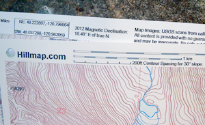
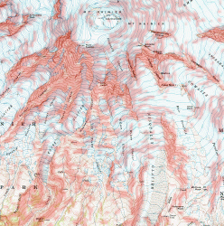
View, Print and Share Free High Quality Topographic Maps

Use the print tool to print high quality maps.

Use the split screen toggle in the upper left to compare map layers.

Use the link button to share your maps.

Use the search tool to find a named place.

Click the
Hillmap logo to collapse the topbar and focus on the maps.

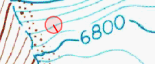
Analyze Terrain Point by Point

Activate the Points tab and click the map to measure the elevation, location and slope at a point anywhere in the world. Links to a weather.gov forecast for the point and a peakfinder.org panoramic display of visible named peaks will also appear.

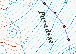
Profile and Plan Trips

Use the Paths tab to construct and measure a route or trail.

Paths can be imported from and exported to GPX files for use with a GPS via drag and drop or the Tools menu.

Highlight Avalanche Prone Slopes

Avalanches are most common on slopes steeper then 28 °. Hillmap provides four ways to analyze slope angles.

  • Use the Points tab to check the slope at a point anywhere in the world.
  • In the Paths tab the overall slope of the last line added to the path is displayed to assist in measuring longer paths.
  • Use the Slope Analysis layer on the Overlays tab under Data Layers to do custom slope analysis for anywhere in the US.
  • Caltopo slope layers for the US are also on the Overlays tab.
Examples and Tutorials
 
  • Like
Reactions: Steve

MLSWK2

Rank II
Launch Member

Enthusiast I

404
Cameron Park
Member #

4535

Out in the field I use Backcountry Navigator Pro on my Android Phone and tablet. Maps are downloadable to the device. No internet connection needed. Make sure your device has a GPS chip.

BN has the US Forest Service Motor Vehicle Use Maps available for purchase as a layer. This layer displays on top of the map layer you are using. Very useful for navigating Forest Service roads and trails.

I always carry printed maps also.