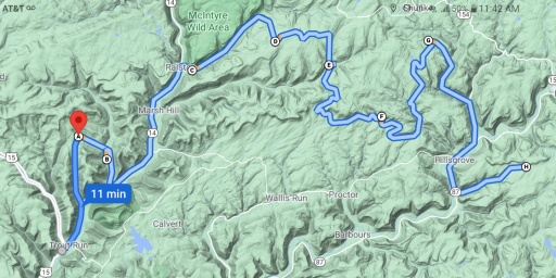
Worked out a route today.
So the first thing I do is go to the Legend and see what is up. And right off I notice no 4x4 High Clearance roads. So no need to seek them out. Next I look for motorized campsites. Seems the area has quite a few. Then I scope out the purple lizards. If I remember correctly...this place has lots of water falls. Then I check out how it connects to other lizard maps/state forests...looks like Pine creek and bald eagle border it. So now to decide the set in point.
So...looking at this...a 2 hr drive is ahead of me. And looking for campsites and lizards... I decided the area just North and East of Trout run will be my primary region to explore out across the northern section of map.
So the set in point for the area will be Steam Valley Travel Plaza in Trout Run. This will allow for a restroom break, and fuel for both the truck and family.
So setting in just north of Trout Run. Time to plot a route.
Looks a lot like Sproul...with many dead end roads. Found the waterfalls and sites 1 and 2. Probably gonna skip the dead end roads for a scouting trip...save them for a camping weekend. It does look like there is a good amount of forest roads to be wandered though.
route plotted from Steam Valley TP to Worlds End SP. There is a lot to see here. And some of it is out those dead end roads.
Located many of the lizards and camp sites.
Heading out from SVTP to Hagerman Run Rd taking it to Dry Run road and motorized sites 1 and 2. Then going back to Rt 14. Note: Bodine Mt Rd looks interesting, but it goes out to nowhere and dead ends.
Now head up to Ralston to Rock Run Road and the start of miles of forest roads. Note: McIntyre Ghost town is right here...but another dead end road.
Rock Run Rd has alot of waterfalls and leads to site 36 off Yellow Dog road at the intersection with Ellenton Ridge Rd. Then head on Masten Rd down to the Masten Camping area. Then Hillsgrove road to Cascade Rd and site 50 and 49 on Big Hollow Road. This has taken me through the western side of the map.
Then hit Mill Creek Rd to Camels Rd to sites 42 43 41 and 40. Note: sites 44 45 46 47 can be seen by taking Walker Rd...but again...it dead ends(unless anyone knows if that is a seasonal gate at site 47)
Then take Dry Run Rd to Hoagland Branch Rd and down to Route 87 to Dry Run rd(lots of roads named this here) to head past site 74 73 then onto High Knob Rd and then the Worlds End SP area.
Loyalsock west to east route.
2 hr 24 min (60 mi)
Google Maps
