

Member I
(Feel free to connect to existing threads if they exist)
KAT was Developed by Jeff Stoess and friends.
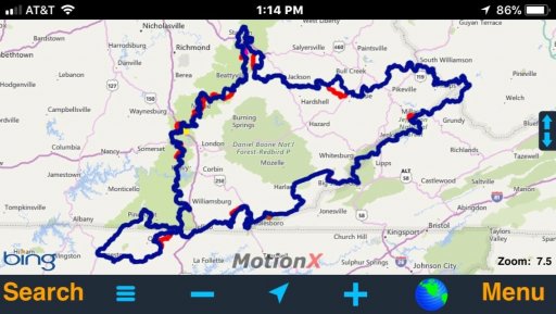
This is a 1000 mile loop (not counting the hard sections) around the hills and mountains of south eastern KY,TN,VA and WV. It is about 40% rural narrow twisty paved roads with the rest being gravel, dirt roads and trails for street legal Bikes and 4x4s.
http://annessky.net/kat/
FB group: https://m.facebook.com/groups/121845738390272
From FB:
“It will take 5 full summer days of riding to complete the main loop. It will take 5-6 days if you take the hard sections. Some of these areas are very remote so do not go alone! The average distance between gas stops is around 60 miles. I have marked as waypoints the gas stations, food and hotels (there are others on the loop that I don't have marked).
This loop does go through some active coal mining areas but the roads are still open to the public. You may run into a situation where the road is shut down due to work or blasting. There will be a security guard and or signs, the guards that I have spoken with are very friendly and more than happy to tell you a way around.
...
As far as trucks go, the main loop can be done in fairly stock 4x4's but keep in mind there are sections with rocks, some mud, creek crossings and hills so I highly recommend that you have experience in these conditions and run an aggressive tire of at least 31". A rear locker would be very useful.
For the 4x4 hard sections, you will want aggressive tires, 31's will be ok if you have at least a rear locker. Recovery gear like a winch is highly recommended. There is a chance that you could receive body damage on these hard sections.
You may run into downed trees and creeks that may be too big or deep to cross. Any of these can be bypassed if you just scroll around on your GPS screen. A small saw or machete comes in handy for the small downed trees.
There are two versions of the KAT, one for motorcycles and one for 4x4s. See the files section to download the most current GPX tracks.
Be sure you get the appropriate file for the vehicle that you will be using. "KAT" for the bikes and "KAT 4x4" for the trucks Trying to get a truck through motorcycle only sections could cause serious damage to the trail and risk having it closed for good.
thanks,
Jeff Stoess”
Needless to say that with this and the #DBBB there is a lot to get out and explore!
I downloaded it and from Gaiai App seemed well put together.
Research I have so far, anybody out there done any part of this massive map.
KAT was Developed by Jeff Stoess and friends.
This is a 1000 mile loop (not counting the hard sections) around the hills and mountains of south eastern KY,TN,VA and WV. It is about 40% rural narrow twisty paved roads with the rest being gravel, dirt roads and trails for street legal Bikes and 4x4s.
http://annessky.net/kat/
FB group: https://m.facebook.com/groups/121845738390272
From FB:
“It will take 5 full summer days of riding to complete the main loop. It will take 5-6 days if you take the hard sections. Some of these areas are very remote so do not go alone! The average distance between gas stops is around 60 miles. I have marked as waypoints the gas stations, food and hotels (there are others on the loop that I don't have marked).
This loop does go through some active coal mining areas but the roads are still open to the public. You may run into a situation where the road is shut down due to work or blasting. There will be a security guard and or signs, the guards that I have spoken with are very friendly and more than happy to tell you a way around.
...
As far as trucks go, the main loop can be done in fairly stock 4x4's but keep in mind there are sections with rocks, some mud, creek crossings and hills so I highly recommend that you have experience in these conditions and run an aggressive tire of at least 31". A rear locker would be very useful.
For the 4x4 hard sections, you will want aggressive tires, 31's will be ok if you have at least a rear locker. Recovery gear like a winch is highly recommended. There is a chance that you could receive body damage on these hard sections.
You may run into downed trees and creeks that may be too big or deep to cross. Any of these can be bypassed if you just scroll around on your GPS screen. A small saw or machete comes in handy for the small downed trees.
There are two versions of the KAT, one for motorcycles and one for 4x4s. See the files section to download the most current GPX tracks.
Be sure you get the appropriate file for the vehicle that you will be using. "KAT" for the bikes and "KAT 4x4" for the trucks Trying to get a truck through motorcycle only sections could cause serious damage to the trail and risk having it closed for good.
thanks,
Jeff Stoess”
Needless to say that with this and the #DBBB there is a lot to get out and explore!
I downloaded it and from Gaiai App seemed well put together.
Research I have so far, anybody out there done any part of this massive map.


