How did you get started?

  • HTML tutorial

Contributor II

98
Mount Holly, NC
First Name
Jeff
Last Name
Giszczak
To all of the seasoned vets on here, how did you find your trails and campsites when you first started out? We are finishing up the rig with our RTT and Rack and want start with some simple weekend trips, but I have no idea where to start with finding trail heads and dispersed camping areas. I thought about starting at campgrounds to break in the gear and introduce my toddler to camping, but it seems like most established campgrounds don't have a spot for RTT camping.

Anyways, thoughts and advise is always welcome, just trying to learn what to look for or what resources would be helpful. Thanks in advance!
 

Mike harpe

Rank V
Launch Member

Enthusiast III

2,030
Georgia
First Name
Mike
Last Name
Harpe
Member #

20679

There are several apps that have trailhead info on it. Alltrails, I-overlander, rei state park maps, us topo maps. Check them out.
 
  • Like
Reactions: BamSilverado15

Flipper

Rank V
Launch Member

Member III

2,865
Florida
First Name
John
Last Name
F
Member #

5021

USFS & BLM campgrounds,State Gazetteers, Pocket Ranger, Oh Ranger park Finder, The Dyrt, Roadtrippers, RV Parky are a couple more.
 

KonzaLander

Rank VI
Member

Traveler II

3,402
Junction City, Kansas, USA
Member #

15814

Ham/GMRS Callsign
KE0EBF
USFS campgrounds are pretty amenable to RTT's.

When I am starting to plan out a trip, rather it be a day trip or multi-week trip, I start out by identify the following on a digital map:
  • Scenic points/places to see
  • Roads that might be fun to drive
  • Historical sites
  • Areas to avoid (known criminal activity, closed roads, closed areas due to environmental factors)
  • Water features (falls, crossings, lakes, etc)
Sometimes, the above is all I load on a navigation device and mark on a paper map before heading out.

If I am guiding folks around an area, trying to meet a deadline or need to plan a specific route, I'll add additional points to the map:
  • Campgrounds
  • Fuel stations in the area
  • Supply locations (grocery, snacks, gear, etc)
  • Trail side camping options visible from aerial maps
  • Connecting trails and alternative routes to alternative sites
By the time you get to the end of this and can determine how many miles you should be able to travel in a day, you get a pretty good route planned with whole lot of information to help you make decisions when out in the woods.
 
  • Like
Reactions: duncanshannon

oldmopars

Rank V
Launch Member

Member III

2,865
Selah Wa
First Name
Scott
Last Name
Solomon
Member #

20486

In addition to all the Apps and sites listed, don't forget Google Maps. I use Google Maps as a starting point. I can see Government land (BLM, FS, State,etc) and see what is out there. Then I can also use Google Earth to see if it is someplace I want to go. You can look at roads, possible camp spots, routes, etc. Never rely solely on Google, but use it as a tool to get ides. Paper maps, Gaia, Garmin, and all the other Apps listed will help navigate you there and you can use them for way points, etc.
YouTube is also a great place to look. Type in the area you think you want to explore and see what comes up. Chances are that someone else has been there and shot a video of it. They will point out things to see, warnings, trails, hotel, food, gas stops, etc.
When you combine all of the resources out there you can get a pretty good plan. Then be flexible and don't over plan, allow adventure to happen. If you see something interesting along the way, stop and explore it. I know some people need rigid plans, but try to allow for surprises that can come. Serendipity, sometimes the coolest things are seen or happen when not planned.
 
  • Like
Reactions: BamSilverado15

M Rose

Local Expert
Mod Team
Member

Advocate III

5,584
Northeast Oregon, United States
First Name
Michael
Last Name
Rose
Member #

20990

Ham/GMRS Callsign
W7FSB
Service Branch
US ARMY Retired
I guess I might be one of the few that was lucky enough to be raised in Overlanding, but back then we just called it camping. My dad would load all the gear, us kids and my mom into his old 1969 International Scout 800 and hit the dirt roads. we would pass by the state camp grounds as we headed deeper into the mountains, find a wide spot in the road and set up camp.
When I got to be in my late teens I bought a 1960 Willys wagon that served as my dedicated overland rig. it had plenty of room for all my gear, friends and thier supplies, and I could through the canoes on top for the lakes and rivers if we were so inclined.

Now 20 years later and after many different rigs and gear setups I have gone to a 1988 Ford Bronco and several backpacking tents. looking at getting a canoe and a couple of kayaks to through on top to ditch my inflatable rafts I currently use.

Back on topic though, just drive down a FS road, find a dead end and set up camp. after going out several times you will find out what works formyou, and what doesnt.
 
  • Like
Reactions: BamSilverado15

Boostpowered

Rank VI

Member III

4,879
Hunt county, TX, USA
First Name
Justin
Last Name
Davis
Member #

14684

Ive always been a dirt/mud magnet, i played in dirt, mud and liked to splash in puddles as a kid and still do. I did alot of camping when i was younger and alot of offroading. I used to just go explore blindly then i started to plan where to go based on where i had been. I stopped camping and offroading for 14 years to pursue a different hobby, that hobby wore me out so i went back to offroading then i started wanting to camp every now and then. Now i look at mvum, nfs visitor map and google earth to find places to do both. Sometimes i just go out and try my hardest to get lost, my internal compass doesn't allow me to though
 
  • Like
Reactions: BamSilverado15

Contributor II

98
Mount Holly, NC
First Name
Jeff
Last Name
Giszczak
Thank you for all of the stories and tips. I didn't get to do much camping when I was younger but I want to raise my son outdoors and my wife loves travelling so we figured this is a great way to kill two birds with one stone. I'll look into all of these resources and try to "get lost." Thanks again everyone! If anyone else has any other ideas and tips, keep them coming. Maybe this will be able to help others as well!
 

Contributor II

98
Mount Holly, NC
First Name
Jeff
Last Name
Giszczak
newbie here and i can safely say GAIA GPS is probably the most useful tool for finding locations!
I've downloaded Gaia, but I currently have the free membership and I feel like I would need to get the premium so I can use the offline maps as well as check out the overland map options. Which version do you have? Have you had any issues while utilizing the maps?
 
  • Like
Reactions: RJCanyon

Boostpowered

Rank VI

Member III

4,879
Hunt county, TX, USA
First Name
Justin
Last Name
Davis
Member #

14684

Tr
I've downloaded Gaia, but I currently have the free membership and I feel like I would need to get the premium so I can use the offline maps as well as check out the overland map options. Which version do you have? Have you had any issues while utilizing the maps?
Try using an app called offline maps its free and has nfs mvum layers and other layers you dont have to purchace
 

RJCanyon

Rank V
Member

Member III

2,766
California, USA
First Name
Bobby
Last Name
Horne
Member #

19131

I've downloaded Gaia, but I currently have the free membership and I feel like I would need to get the premium so I can use the offline maps as well as check out the overland map options. Which version do you have? Have you had any issues while utilizing the maps?
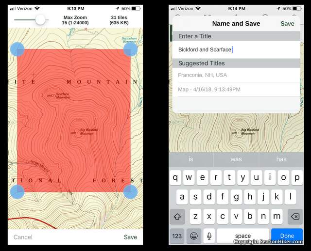
I am using it on iOS and i am on the free membership, however you can download maps for offline use for free. I have multiple saved on my phone and it works fine. below is step by step on how to download a map for iOS!