High Water Mark Trail - April 2017
- Thread starter The GrooGrux King
- Start date


MaceBewley
Rank II

Enthusiast II

Best of luck. Should be in great shape in the fall, with water crossings at their lowest. I would recommend a chainsaw though!Got a group planning on doing this trail in the fall!


Enthusiast III
Got room for any more?Got a group planning on doing this trail in the fall!
Would a Suburban fit this trail? How would a Suburban handle the water crossings? I'm slightly worried about the weight of the truck.

Ran this trail this past weekend. Water was very low (in some places non-existent). Several down trees in one section so we turned around and bypassed it (we cleared what we could in other areas but there were too many in this one spot). Other sections had recently been bulldozed which made the trail almost too easy in those sections.
As for running a Suburban on it....good luck. There are several sections that are very tight and the 4 door Jeeps had issues navigating between the trees.
As for running a Suburban on it....good luck. There are several sections that are very tight and the 4 door Jeeps had issues navigating between the trees.
Enthusiast III

Contributor III
Hey guys! Planning on hitting this trail later this month on out way back from New Mexico to Georgia. Anyone have recent info on it or updated Gaia maps? Downloaded a set from 2017, but want to make sure we stay where we’re allowed
I would plan on walking any water crossings you come to... we have had tons of rain over the last 6 months and I’m willing to bet the river levels are higher than they have been in years. Plus, it’s spring...Hey guys! Planning on hitting this trail later this month on out way back from New Mexico to Georgia. Anyone have recent info on it or updated Gaia maps? Downloaded a set from 2017, but want to make sure we stay where we’re allowed
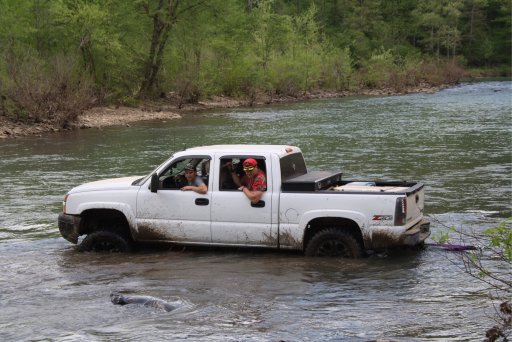
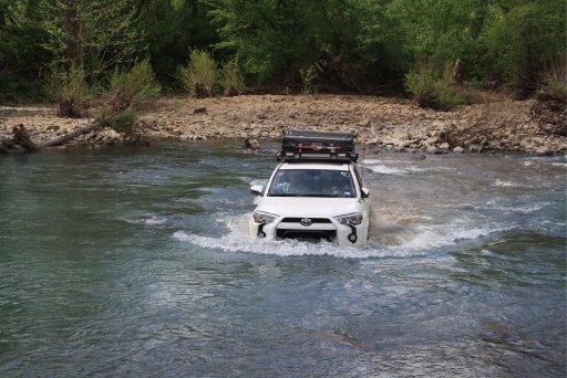
Those two pics are from two summers ago and that Silverado was on 9” of lift and 37s.
Be careful out there!

I'm planning on running a part of this as a weekend trip with a small group in early February, weather permitting. Thanks for the info here!
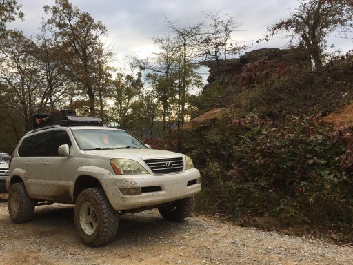
We actually went on parts of it this weekend. Water wasnt high. Maybe on one crossing it came to the bottom of our GX on 35s and about 3" lift. Ill try and post some video later. But they did get some rain up there. Im not sure how quickly the levels change, but I couldnt imagine itll get to high.I'm planning on running a part of this as a weekend trip with a small group in early February, weather permitting. Thanks for the info here!
Attachments
-
 348.3 KB Views: 13
with the recent changes on the 2019 MVUM maps there are currently no legal HWM routes. Every one takes you on closed trails. Be sure to compare any routes to the current MVU Maps to avoid getting a ticket for being on a closed trail.I'm planning on running a part of this as a weekend trip with a small group in early February, weather permitting. Thanks for the info here!
I'm fairly familiar with the area. The water can rise quickly but usually drops quickly as well. I would love to see more videos of the trail!We actually went on parts of it this weekend. Water wasnt high. Maybe on one crossing it came to the bottom of our GX on 35s and about 3" lift. Ill try and post some video later. But they did get some rain up there. Im not sure how quickly the levels change, but I couldnt imagine itll get to high.
We are keeping the MVUM maps up as our baseline mapping tool. We'll just be putting together whatever we can on the HWMT that is still open. I did notice there were many more closed roads than there used to be.with the recent changes on the 2019 MVUM maps there are currently no legal HWM routes. Every one takes you on closed trails. Be sure to compare any routes to the current MVU Maps to avoid getting a ticket for being on a closed trail.
the Gaia MVUM Overlay has not been updatedto match the new maps yet.We are keeping the MVUM maps up as our baseline mapping tool. We'll just be putting together whatever we can on the HWMT that is still open. I did notice there were many more closed roads than there used to be.
I'm using the National Forest Service interactive map, not the Gaia overlay. Forest Service Visitor Mapthe Gaia MVUM Overlay has not been updatedto match the new maps yet.
excellent!I'm using the National Forest Service interactive map, not the Gaia overlay. Forest Service Visitor Map
The trip was great. Ended up having 3 rigs and 3 (really 2.5) days on the trail. Had to re-route due to the first river crossing, but hooked back up on the trail fairly quickly.
I’ll definitely be going back!
I’ll definitely be going back!

