
This is a topic driving me crazy ad I haveZERO experience with GPS for trails. If it's on Waze I'm good. Im taking a trip on the Trans America Trail in July. I am buying GPS tracks to supplement my hard maps. What is a decent unit to upload tracks to? Any input is much appreciated. Was looking at an etrex 30. I'm pretty good at a few things, but smart enough to look for help on this topic.I have a Garmin 76CX handheld, I have the chips for US waterways, topo for SE U.S. and Rocky Mountains and inland lakes and waterways, its waterproof and floats, had it for years, never had a issue, mega versatile, used to work at a West Marine, sold hundreds of Garmins, one thing about Garmins they are very user friendly, I could usually teach someone to operate one in about 15 min.
Sent from my iPad using OB Talk
GPS - Wearables/Handhelds
- Thread starter SeguineJ
- Start date
You are using an out of date browser. It may not display this or other websites correctly.
You should upgrade or use an alternative browser.
You should upgrade or use an alternative browser.
I have heard that lots of people have success with Garmin units. You need to make sure that they can take a .gpx file, and it'll work.
Here's some YouTube videos I've found that you might find helpful...
-How to upload GPX files to Garmin units.
As for making a custom GPX files, there's a really awesome tool I love called CalTopo... www.caltopo.com
Here's a bunch of videos of people using that site for making custom navigation routes/points/tracks, etc. It's pretty neat. There's even a layer that can map historic forest fires and such so you can see the date and area burned. Really handy in the mountains. If you choose the MapBuilder topo layer as your base, you also get loads of trails and fire roads up.
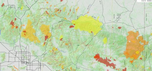
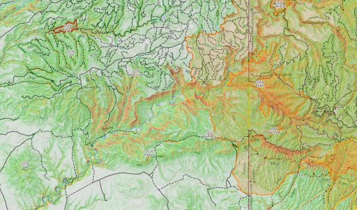
Here's some images from maps I've made...The fires North of Tucson, mapped and color coded in three year categories...reddest are most recent. And then a detail photo of that same map. I just picked an interesting area. I've shaded the terrain by gradient...green is flattest, purple is steepest. Really handy.
Here's some YouTube videos I've found that you might find helpful...
-How to upload GPX files to Garmin units.
As for making a custom GPX files, there's a really awesome tool I love called CalTopo... www.caltopo.com
Here's a bunch of videos of people using that site for making custom navigation routes/points/tracks, etc. It's pretty neat. There's even a layer that can map historic forest fires and such so you can see the date and area burned. Really handy in the mountains. If you choose the MapBuilder topo layer as your base, you also get loads of trails and fire roads up.
Here's some images from maps I've made...The fires North of Tucson, mapped and color coded in three year categories...reddest are most recent. And then a detail photo of that same map. I just picked an interesting area. I've shaded the terrain by gradient...green is flattest, purple is steepest. Really handy.
Attachments

This is a topic driving me crazy ad I haveZERO experience with GPS for trails. If it's on Waze I'm good. Im taking a trip on the Trans America Trail in July. I am buying GPS tracks to supplement my hard maps. What is a decent unit to upload tracks to? Any input is much appreciated. Was looking at an etrex 30. I'm pretty good at a few things, but smart enough to look for help on this topic.
For iOS GAIA GPS!
For Android: Gaia GPS, Back Country Navigator, there are a few smaller players as well.
For a dedicated device I can't help you. I gave up on them once smartphones and tablets came out. Post above looks very useful for Garmin devices.

I'm a big believer in people "owning" their data...so knowing where the data comes from, how current it is, and how reliable it is....are all very important.
Which is why I like a mapping program that allows flexibility to import and export as much as possible. I've NEVER found a handheld device that had great data, and very few devices that had a software package that gave me all the tools I needed.
I will certainly be trying GAIA here very soon. I've only heard about it once I joined this community.

I tried Backcountry Navigator today, along with CalTopo. Didn't really work out the way I wanted, but it was a last minute discovery and I didn't have time to get very familiar with them. I'll have to spend a bit more time on them to see how they work. Regardless, I'm not thrilled with the ads in Backcountry Navigator being in the way when I'm trying to use the app.
I tried Backcountry Navigator today, along with CalTopo. Didn't really work out the way I wanted, but it was a last minute discovery and I didn't have time to get very familiar with them. I'll have to spend a bit more time on them to see how they work. Regardless, I'm not thrilled with the ads in Backcountry Navigator being in the way when I'm trying to use the app.
Free version? My guess is paid version has no ads.
Sent from my iPhone expect typos, grammatical errors, and any other invalid excuse.
Probably. Didn't even know there was a paid version. Does it have any other features that the free one doesn't, besides not having ads? I haven't played with it enough to decide if I want the paid version.

Traveler III
Remember, this thread is a handheld and wearable GPS discussion. We already have umpteen threads about iOS and Android GPS software where those topics can be discussed.
Remember, this thread is a handheld and wearable GPS discussion. We already have umpteen threads about iOS and Android GPS software where those topics can be discussed.
My phone is a handheld but yeah sorry for the thread drift. As Steve mention look for other posts within this section of the forums.
Sent from my iPhone expect typos, grammatical errors, and any other invalid excuse.

Explorer I
Anyone have recommendations that they actually use? Looking to get for both overland and my LEO side of the house. Prefer to get something that someone has a real recommendation or has used. Especially spending this much money on average haha.
Unconditionally recommend the Garmin Rino line - a capable GPS coupled with FRS/GMRS radio. I have had two GPSs that I felt were truly capable - the Rino and an expensive Garmin flight GPS. You can pay to put better maps on it (I never have as I mostly use a different setup for nav) and if your buddy has one you can see each other on your screen. The battery lasts about 37.45 years and it is a great waypoint/track gatherer and quick comm device. Mine has overlanded thousands of miles on motorcycles and cars and never missed a beat. In fact I am pleased as punch that the "dash board hole-der" in my new JKU seems to be made to hold a Rino. :)
In reality most anything rugged from any well-known mfgr will do the trick. I just love my Rino 530 and Garmin products in general.
Thank you for your service (LEO)!
Explorer I
I would personally recommend staying away from SPOT. In fact I have a gen 1 that the first responder can have - it needs to be reactivated.I've heard good things about Spot Messenger... but I have no first-hand knowledge of it.
https://www.findmespot.ca/en/
In my experience the SPOT system goes down enough making the little puck less useful than an ashtray at Bible camp. Yes - I lost coverage for DAYS on a motorcycle trip up the AlCan because of technical difficulties on their side - the very thing I bought the SPOT for to help ease my wife's nerves about the trip. When I contacted SPOT I was promised a year of free service which never materialized (I was promised a year free on at least two occasions). In general dealing with SPOT on the phone is a no-win situation.
Carry one for novelty and a possible emergency? Why not it could not hurt (other than your wallet). Trust your life to that company? My experience says no.
Off of my soapbox ;) Hahaha
