
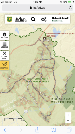
I was wondering how accurate the trail maps are on the FS website. My wife and I went on a trip and not knowing the area of the quachita NF we stayed mainly to main roads that were well traveled. Now I am looking back at the roads we traveled and a lot of them are showing to be closed to vehicles over 50”. These were nice, maintained roads that we met quite a few other vehicles on including duallys and small cars. The map legend shows they are trails suitable for passenger cars but also have the pink/peach colored highlight on them? Most were big enough u could pass a semi on. I am new to all of this and just trying to figure stuff out for our next trip. Thanks in advance
Forest service website accuracy?
- Thread starter Weston
- Start date
You are using an out of date browser. It may not display this or other websites correctly.
You should upgrade or use an alternative browser.
You should upgrade or use an alternative browser.

I was wondering how accurate the trail maps are on the FS website. My wife and I went on a trip and not knowing the area of the quachita NF we stayed mainly to main roads that were well traveled. Now I am looking back at the roads we traveled and a lot of them are showing to be closed to vehicles over 50”. These were nice, maintained roads that we met quite a few other vehicles on including duallys and small cars. The map legend shows they are trails suitable for passenger cars but also have the pink/peach colored highlight on them? Most were big enough u could pass a semi on. I am new to all of this and just trying to figure stuff out for our next trip. Thanks in advance
Here is another example. I know these roads and have traveled them for years. They show the same thing. Am I missing something?
Attachments


Off-Road Ranger I
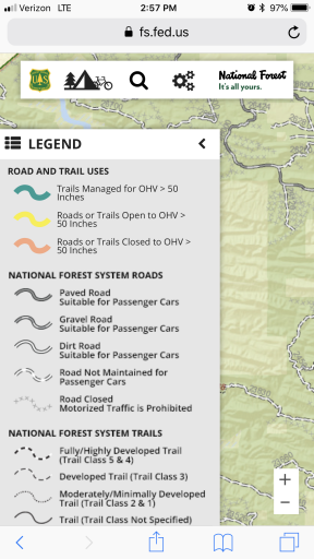
You are fine on those roads. the 50" is for width, not length in case that wasn't already clear. Here's the MVUM road/trail legend which will help make sense of all the lines, dots, dashes, and grey highlights found on the maps.

source: https://www.fs.fed.us/r3/gis/Images/newMVUMLegend.pdf
source: https://www.fs.fed.us/r3/gis/Images/newMVUMLegend.pdf
Off-Road Ranger I

Boostpowered
Rank VI

Member III


I was wondering how accurate the trail maps are on the FS website. My wife and I went on a trip and not knowing the area of the quachita NF we stayed mainly to main roads that were well traveled. Now I am looking back at the roads we traveled and a lot of them are showing to be closed to vehicles over 50”. These were nice, maintained roads that we met quite a few other vehicles on including duallys and small cars. The map legend shows they are trails suitable for passenger cars but also have the pink/peach colored highlight on them? Most were big enough u could pass a semi on. I am new to all of this and just trying to figure stuff out for our next trip. Thanks in advance
If you want to run the trails up in ouachita start with the rattan trail or cloudy trail. Just stay to the trails that dont have a gate closed. Your welcome to join my wife and myself next time we go to the ouachita.
Edit: Sorry i forgot that the ouachita nf isnt bigger, the area i go to is black jack mnt. I still would highly recommend the rattan, nashoba, cloudy oklahoma area there are alot of open trails with varying degrees of difficulty and the mountains are really pretty. Offer still stands to join us
Last edited:


View attachment 75672 View attachment 75673
If you want to run the trails up in ouachita start with the rattan trail or cloudy trail. Just stay to the trails that dont have a gate closed. Your welcome to join my wife and myself next time we go to the ouachita.
Edit: Sorry i forgot that the ouachita nf isnt bigger, the area i go to is black jack mnt. I still would highly recommend the rattan, nashoba, cloudy oklahoma area there are alot of open trails with varying degrees of difficulty and the mountains are really pretty. Offer still stands to join us
Looking forward to joining y'all next spring!
We ran roads all the way around broken bow lake. Had a great time. Just trying to figure out why their map is shaded with those colors on roads that apparently are open? Guess I should have stopped by the ranger station and got one of their maps to compare. I will keep u n mind if we head back that way. Our next run will probably be the ozarks or around Silverton CO
